![](/images/other/stat-length.png)
![Trail Walking Arrens-Marsous - Le refuge du Larribet - Photo](https://media.geolcdn.com/t/1900/400/ext.pjpeg?maxdim=2&url=https%3A%2F%2Fservices.sitytrail.com%2FGeolivesWS%2FDownloadMedia.ashx%3FTrailID%3D109616%26Media%3D4248_5.jpg)
Le refuge du Larribet
tracegps
User
![Length](/images/other/stat-length.png)
![Max alt](https://static1.geolcdn.com/siteimages/upload/files/1508320355ic_sort_altitude_max_24dp.png)
![Uphill gradient](https://static1.geolcdn.com/siteimages/upload/files/1508320355ic_sort_den_pos_24dp.png)
![Km-Effort](/images/other/stat-length.png)
![Min alt](https://static1.geolcdn.com/siteimages/upload/files/1508320355ic_sort_altitude_min_24dp.png)
![Downhill gradient](https://static1.geolcdn.com/siteimages/upload/files/1508320355ic_sort_den_neg_24dp.png)
![Boucle](https://static1.geolcdn.com/siteimages/upload/files/16400158638029165_repeat_loop_refresh_sync_direction_icon.png)
![Walking](https://static1.geolcdn.com/sitytour/trail-icons/101.png)
5h55
Difficulty : Difficult
![Scan this QR Code to open this trail in the SityTrail application](https://capi.geolives.com/qq0zvz2zws4bq2lad0pu/sitytour/trails/109616/qr.png?size=200)
FREE GPS app for hiking
About
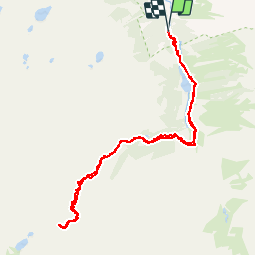
Trail Walking of 10.3 km to be discovered at Occitania, Hautespyrenees, Arrens-Marsous. This trail is proposed by tracegps.
Description
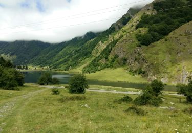
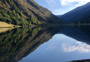
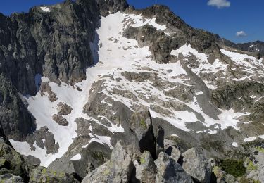
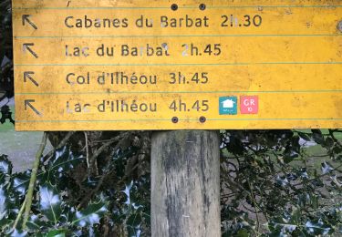
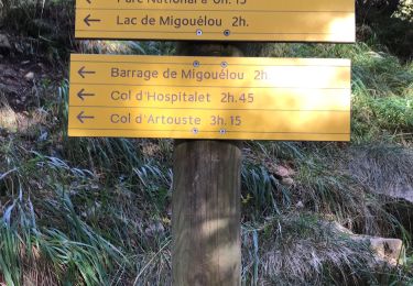
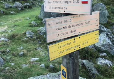
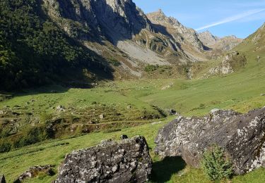
Passer devant la Maison du Parc National de Pyrénées et remonter le sentier forestier rive gauche du Gave d'Arrens. Passer la passerelle et rejoindre le large chemin en bordure du Lac de Suyen (0:20). Laisser à gauche le sentier menant au Port de la Peyre St Martin et rejoindre la Cabane de Doublas rive gauche du gave (0:40). Passer devant la Toue de Doublas et remonter à l'Est le vallon du ruisseau de Larribet. La pente se redresse pour accéder à La Claou (1:20) puis se radoucit et la vallée s'élargit. Une passerelle permet de passer rive droite du ruisseau (1:55). On aperçoit à droite la Toue de Larribet. Progresser jusqu'au fond du cirque (2:20) et remonter la rude pente permettant de rejoindre le Refuge du Larribet (3:00). Magnifique vue sur le cirque du Pabat surmonté par le Balaïtous agrémentée d'une bonne bière, que demander de plus ! La descente se fait par le même chemin pour retrouver la Porte du Parc National des Pyrénées (5:55).
Positioning
Comments
Trails nearby
![Trail Walking Estaing - ESTAING RS le der de 2022 - Photo](https://media.geolcdn.com/t/375/260/0404f897-2945-4225-b4b6-dbaf65ce5d84.jpg&format=jpg&maxdim=2)
![Walking Walking](https://static1.geolcdn.com/sitytour/trail-icons/101.png)
Walking
![](/images/other/stat-length.png)
![](https://static1.geolcdn.com/siteimages/upload/files/16400158638029165_repeat_loop_refresh_sync_direction_icon.png)
![Trail Walking Estaing - Ruines et lac de Liantran - Photo](https://media.geolcdn.com/t/375/260/1b91bce4-1111-454c-9093-1e2ab24d6024.jpg&format=jpg&maxdim=2)
![Walking Walking](https://static1.geolcdn.com/sitytour/trail-icons/101.png)
Walking
![](/images/other/stat-length.png)
![](https://static1.geolcdn.com/siteimages/upload/files/16400158638029165_repeat_loop_refresh_sync_direction_icon.png)
![Trail Walking Arrens-Marsous - pic de cristayet - Photo](https://media.geolcdn.com/t/375/260/4c1e26d5-197f-441e-9709-6adb4628c945.jpg&format=jpg&maxdim=2)
![Walking Walking](https://static1.geolcdn.com/sitytour/trail-icons/101.png)
Walking
![](/images/other/stat-length.png)
![](https://static1.geolcdn.com/siteimages/upload/files/16400158638029165_repeat_loop_refresh_sync_direction_icon.png)
![Trail Walking Estaing - Pyrénées jour 4 - Photo](https://media.geolcdn.com/t/375/260/5c6b756a-151d-456f-a813-d2eed350fb7d.jpg&format=jpg&maxdim=2)
![Walking Walking](https://static1.geolcdn.com/sitytour/trail-icons/101.png)
Walking
![](/images/other/stat-length.png)
![](https://static1.geolcdn.com/siteimages/upload/files/16400158638029165_repeat_loop_refresh_sync_direction_icon.png)
![Trail Walking Arrens-Marsous - Pyrénées jour 3 - Photo](https://media.geolcdn.com/t/375/260/f0337aed-7c8f-4a4e-8cd6-fd5a1a5be425.jpg&format=jpg&maxdim=2)
![Walking Walking](https://static1.geolcdn.com/sitytour/trail-icons/101.png)
Walking
![](/images/other/stat-length.png)
![](https://static1.geolcdn.com/siteimages/upload/files/16400158638029165_repeat_loop_refresh_sync_direction_icon.png)
![Trail Walking Arrens-Marsous - Pyrénées jour 2 - Photo](https://media.geolcdn.com/t/375/260/47560504-9532-4271-bcaa-9f510a9d197b.jpg&format=jpg&maxdim=2)
![Walking Walking](https://static1.geolcdn.com/sitytour/trail-icons/101.png)
Walking
![](/images/other/stat-length.png)
![](https://static1.geolcdn.com/siteimages/upload/files/16400158638029165_repeat_loop_refresh_sync_direction_icon.png)
![Trail Walking Arrens-Marsous - Tech - Ausseila. - Photo](https://media.geolcdn.com/t/375/260/12428191-124f-4fd1-ab66-0d522905b93b.jpg&format=jpg&maxdim=2)
![Walking Walking](https://static1.geolcdn.com/sitytour/trail-icons/101.png)
Walking
![](/images/other/stat-length.png)
![](https://static1.geolcdn.com/siteimages/upload/files/16400158638029165_repeat_loop_refresh_sync_direction_icon.png)
![Trail Walking Arrens-Marsous - Refuge de LARRIBET - Photo](https://media.geolcdn.com/t/375/260/a45753d2-1ce8-41ec-9fa9-20d3b65809a7.jpg&format=jpg&maxdim=2)
![Walking Walking](https://static1.geolcdn.com/sitytour/trail-icons/101.png)
Walking
![](/images/other/stat-length.png)
![](https://static1.geolcdn.com/siteimages/upload/files/16400158638029165_repeat_loop_refresh_sync_direction_icon.png)
![Trail Walking Estaing - Circulaire lac Estaing par brèche de Hourat - Photo](https://media.geolcdn.com/t/375/260/26209189-3d34-4e85-887a-a4af7697d195.jpg&format=jpg&maxdim=2)
![Walking Walking](https://static1.geolcdn.com/sitytour/trail-icons/101.png)
Walking
![](/images/other/stat-length.png)
![](https://static1.geolcdn.com/siteimages/upload/files/16400158638029165_repeat_loop_refresh_sync_direction_icon.png)