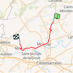
![](/images/other/stat-length.png)
![Trail Walking Durfort-Lacapelette - St Martin - Bouillan - Chemin de Compostelle - Photo](https://media.geolcdn.com/t/1900/400/ext.pjpeg?maxdim=2&url=https%3A%2F%2Fservices.sitytrail.com%2FGeolivesWS%2FDownloadMedia.ashx%3FTrailID%3D109582%26Media%3D4205_5.jpg)
St Martin - Bouillan - Chemin de Compostelle
tracegps
User
![Length](/images/other/stat-length.png)
![Max alt](https://static1.geolcdn.com/siteimages/upload/files/1508320355ic_sort_altitude_max_24dp.png)
![Uphill gradient](https://static1.geolcdn.com/siteimages/upload/files/1508320355ic_sort_den_pos_24dp.png)
![Km-Effort](/images/other/stat-length.png)
![Min alt](https://static1.geolcdn.com/siteimages/upload/files/1508320355ic_sort_altitude_min_24dp.png)
![Downhill gradient](https://static1.geolcdn.com/siteimages/upload/files/1508320355ic_sort_den_neg_24dp.png)
![Boucle](https://static1.geolcdn.com/siteimages/upload/files/16400158638029165_repeat_loop_refresh_sync_direction_icon.png)
![Walking](https://static1.geolcdn.com/sitytour/trail-icons/101.png)
10h00
Difficulty : Very difficult
![Scan this QR Code to open this trail in the SityTrail application](https://capi.geolives.com/qq0zvz2zws4bq2lad0pu/sitytour/trails/109582/qr.png?size=200)
FREE GPS app for hiking
About
Trail Walking of 26 km to be discovered at Occitania, Tarn-et-Garonne, Durfort-Lacapelette. This trail is proposed by tracegps.
Description
Lever 6H15 et très bon petit déjeuner au gîte de St Martin près de la Chapelle (Mr et Mme Sykes, St Martin, Durfort Lacapelette, 05 63 04 41 58). Départ 7H40. Passer devant la chapelle St Martin et tourner à droite sur la route qui mène à la D16 (0:25). Traverser et suivre le sentier aménagé en contre bas de la route sur 1.5km environ. En face de Goujou, tourner à gauche pour prendre le chemin montant à Fournaise (1:00). Après avoir traversé le ruisseau de Laujol, un panneau sympathique indique que si on poursuit le chemin on le fait à ses risques et périls ! Prendre à droite le chemin qui suit le Laujol, ce n'est pas la peine de s'aventurer chez les sauvages ! Après 300m environ, le sentier remonte à gauche sur le plateau et rejoint une route goudronnée (1:30). Prendre à droite et passer Carbonnière, Le Tuc, Epis, Aujoy puis Le Casse où on amorce la descente vers la vallée du Laujol. Au croisement, prendre un sentier en face, traverser le Laujol et rejoindre la D957 (3:10). Prendre à gauche, puis 50m avant de rejoindre la D927, prendre une parallèle à droite (On peut éviter la monotonie de l'arrivée sur Moissac en prenant un chemin à droite vers Malengane, Landerose et Cassan pour rejoindre l'Abbatiale St Pierre, mais c'est un peu plus long et plus vallonné). Rejoindre la D927, passer la voie ferrée et aller au centre de Moissac devant l'Abbatiale St Pierre(4:00). Rejoindre à l'Ouest la D7 puis dans le prolongement, la N113 jusqu'à la gare. En face, quitter la N113 pour passer le pont sur le Canal Latéral à la Garonne (4:30). Tourner à droite suite au pont et longer le Canal. Le chemin vient d'être refait mais goudronné, idéal pour les vélo mais pas génial pour les marcheurs. L'endroit est paisible et propice à la pose repas ! (5:00). (6:10) Passer l'écluse de l'Espagnette, (à cet endroit, le GR65 traverse le Canal et remonte vers Boudou, nous avons choisi de suivre le Canal à cause de la chaleur et pour éviter les dénivelés), le Pont de Coudol (6:40), l'écluse de Petit Bezy (7:15), le pont sur la D26bis (8:10), le pont de St Jean (8:20) et enfin le pont de Malause (8 :30), une petite halte goûter s'impose à l'ombre des platanes ! C'est à cet endroit que l'on rejoint le GR65 (voie normale). Si comme nous votre gîte est au Bouillan, traverser le pont et se diriger vers l'église de Malause (9:10) puis prendre à droite la D4 sur environ 100m. Rejoindre à gauche La Garenne (9:20) puis au croisement à gauche Les Bordes (9:35) et Bretounel (9:45). Au croisement, prendre en face puis traverser le ruisseau de la Saudèze. Au croisement poursuivre la route sur 100m pour gagner le Bouillan (10:00). Nous avions réservé nos nuités et nos repas au gîte Le Grenier du Levant (Annie et Raymond Granier, Lieu-dit "Bouillan", 82400 Saint-Vincent Lespinasse, 05 63 29 07 14). Très bon accueil et ambiance familiale.
Positioning
Comments
Trails nearby
![Trail Walking Durfort-Lacapelette - Mon Compostelle neuvième étape - Photo](https://media.geolcdn.com/t/375/260/ext.jpg?maxdim=2&url=https%3A%2F%2Fservices.sitytrail.com%2FGeolivesWS%2FDownloadMedia.ashx%3FTrailID%3D684076%26Media%3Dcf9f196a-5b71-43f7-b867-ea4ea4fb3350.JPG)
![Walking Walking](https://static1.geolcdn.com/sitytour/trail-icons/101.png)
Walking
![](/images/other/stat-length.png)
![](https://static1.geolcdn.com/siteimages/upload/files/16400158638029165_repeat_loop_refresh_sync_direction_icon.png)
![Trail Walking Durfort-Lacapelette - Compostelle Durfort a Espalais - Photo](https://media.geolcdn.com/t/375/260/ext.jpg?maxdim=2&url=https%3A%2F%2Fstatic1.geolcdn.com%2Fsiteimages%2Fupload%2Ffiles%2F1553511878bg_sport_marche.png)
![Walking Walking](https://static1.geolcdn.com/sitytour/trail-icons/101.png)
Walking
![](/images/other/stat-length.png)
![](https://static1.geolcdn.com/siteimages/upload/files/16400158638029165_repeat_loop_refresh_sync_direction_icon.png)
![Trail Walking Durfort-Lacapelette - SityTrail - CC_Velay_EA_17_Lauzerte_Moissac_20080817 - Photo](https://media.geolcdn.com/t/375/260/ext.jpg?maxdim=2&url=https%3A%2F%2Fstatic1.geolcdn.com%2Fsiteimages%2Fupload%2Ffiles%2F1553511878bg_sport_marche.png)
![Walking Walking](https://static1.geolcdn.com/sitytour/trail-icons/101.png)
Walking
![](/images/other/stat-length.png)
![](https://static1.geolcdn.com/siteimages/upload/files/16400158638029165_repeat_loop_refresh_sync_direction_icon.png)
![Trail Walking Durfort-Lacapelette - Etape Durfort-Lacapelette à Moissac - Photo](https://media.geolcdn.com/t/375/260/ext.jpg?maxdim=2&url=https%3A%2F%2Fstatic1.geolcdn.com%2Fsiteimages%2Fupload%2Ffiles%2F1553511878bg_sport_marche.png)
![Walking Walking](https://static1.geolcdn.com/sitytour/trail-icons/101.png)
Walking
![](/images/other/stat-length.png)
![](https://static1.geolcdn.com/siteimages/upload/files/16400158638029165_repeat_loop_refresh_sync_direction_icon.png)
![Trail Walking Durfort-Lacapelette - Compostelle 19 - Durfort-Lacapelette -> Moissac - Photo](https://media.geolcdn.com/t/375/260/ext.jpg?maxdim=2&url=https%3A%2F%2Fstatic1.geolcdn.com%2Fsiteimages%2Fupload%2Ffiles%2F1553511878bg_sport_marche.png)
![Walking Walking](https://static1.geolcdn.com/sitytour/trail-icons/101.png)
Walking
![](/images/other/stat-length.png)
![](https://static1.geolcdn.com/siteimages/upload/files/16400158638029165_repeat_loop_refresh_sync_direction_icon.png)
![Trail Walking Durfort-Lacapelette - St Jacques Étape 21 - Photo](https://media.geolcdn.com/t/375/260/ext.jpg?maxdim=2&url=https%3A%2F%2Fstatic1.geolcdn.com%2Fsiteimages%2Fupload%2Ffiles%2F1553511878bg_sport_marche.png)
![Walking Walking](https://static1.geolcdn.com/sitytour/trail-icons/101.png)
Walking
![](/images/other/stat-length.png)
![](https://static1.geolcdn.com/siteimages/upload/files/16400158638029165_repeat_loop_refresh_sync_direction_icon.png)
![Trail Nordic walking Durfort-Lacapelette - De St Martin à Moissac - Photo](https://media.geolcdn.com/t/375/260/ext.jpg?maxdim=2&url=https%3A%2F%2Fstatic1.geolcdn.com%2Fsiteimages%2Fupload%2Ffiles%2F1545311037marcheuse_200dpi.jpg)
![Nordic walking Nordic walking](https://static1.geolcdn.com/sitytour/trail-icons/102.png)
Nordic walking
![](/images/other/stat-length.png)
![](https://static1.geolcdn.com/siteimages/upload/files/16400158638029165_repeat_loop_refresh_sync_direction_icon.png)
![Trail Walking Lauzerte - La garde Haute- Landou par GR65 puisD57 à drte vers le Moulinal D81 crt D16 puis peyrounels - Photo](https://media.geolcdn.com/t/375/260/ext.jpg?maxdim=2&url=https%3A%2F%2Fstatic1.geolcdn.com%2Fsiteimages%2Fupload%2Ffiles%2F1553511878bg_sport_marche.png)
![Walking Walking](https://static1.geolcdn.com/sitytour/trail-icons/101.png)
Walking
![](/images/other/stat-length.png)
![](https://static1.geolcdn.com/siteimages/upload/files/16400158638029165_repeat_loop_refresh_sync_direction_icon.png)
![Trail Walking Durfort-Lacapelette - fabuleux haut -moissac - Photo](https://media.geolcdn.com/t/375/260/ext.jpg?maxdim=2&url=https%3A%2F%2Fstatic1.geolcdn.com%2Fsiteimages%2Fupload%2Ffiles%2F1553511878bg_sport_marche.png)
![Walking Walking](https://static1.geolcdn.com/sitytour/trail-icons/101.png)
Walking
![](/images/other/stat-length.png)
![](https://static1.geolcdn.com/siteimages/upload/files/16400158638029165_repeat_loop_refresh_sync_direction_icon.png)