![](/images/other/stat-length.png)
![Trail Walking Vier-Bordes - Argeles Hautacam le tour du bois de Bordes-fait - Photo](https://media.geolcdn.com/t/1900/400/ext.pjpeg?maxdim=2&url=https%3A%2F%2Fstatic1.geolcdn.com%2Fsiteimages%2Fupload%2Ffiles%2F1553511878bg_sport_marche.png)
Argeles Hautacam le tour du bois de Bordes-fait
Lous Passa camins
convivialite, sport et fiesta
![Length](/images/other/stat-length.png)
Length
11.5 km
![Max alt](https://static1.geolcdn.com/siteimages/upload/files/1508320355ic_sort_altitude_max_24dp.png)
Max alt
1601 m
![Uphill gradient](https://static1.geolcdn.com/siteimages/upload/files/1508320355ic_sort_den_pos_24dp.png)
Uphill gradient
572 m
![Km-Effort](/images/other/stat-length.png)
Km-Effort
19.1 km
![Min alt](https://static1.geolcdn.com/siteimages/upload/files/1508320355ic_sort_altitude_min_24dp.png)
Min alt
1099 m
![Downhill gradient](https://static1.geolcdn.com/siteimages/upload/files/1508320355ic_sort_den_neg_24dp.png)
Downhill gradient
572 m
![Boucle](https://static1.geolcdn.com/siteimages/upload/files/16400158638029165_repeat_loop_refresh_sync_direction_icon.png)
Boucle
Yes
Creation date :
2019-04-29 08:25:17.452
Updated on :
2019-04-29 08:25:17.535
![Walking](https://static1.geolcdn.com/sitytour/trail-icons/101.png)
3h54
Difficulty : Unknown
![Scan this QR Code to open this trail in the SityTrail application](https://capi.geolives.com/qq0zvz2zws4bq2lad0pu/sitytour/trails/1095737/qr.png?size=200)
FREE GPS app for hiking
About
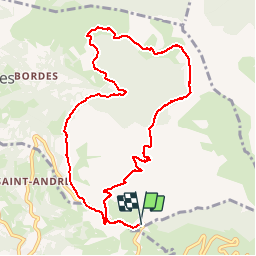
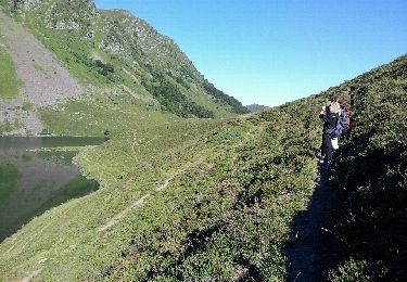
Trail Walking of 11.5 km to be discovered at Occitania, Hautespyrenees, Vier-Bordes. This trail is proposed by Lous Passa camins.
Description
Prevoir de se garer au Parking arinque en direction de l'aire de départ des parapentes
Positioning
Country:
France
Region :
Occitania
Department/Province :
Hautespyrenees
Municipality :
Vier-Bordes
Location:
Unknown
Start:(Dec)
Start:(UTM)
742571 ; 4762769 (30T) N.
Comments
Trails nearby
![Trail Walking Beaucens - Lac d'Ourrec depuis Hautacam - Photo](https://media.geolcdn.com/t/375/260/9579242b-e736-4d3c-b90a-ab67e4e2e4a3.jpg&format=jpg&maxdim=2)
![Walking Walking](https://static1.geolcdn.com/sitytour/trail-icons/101.png)
Lac d'Ourrec depuis Hautacam
Walking
Easy
(1)
Beaucens,
Occitania,
Hautespyrenees,
France
![](/images/other/stat-length.png)
13 km | 20 km-effort
4h 15min
![](https://static1.geolcdn.com/siteimages/upload/files/16400158638029165_repeat_loop_refresh_sync_direction_icon.png)
Yes
![Trail Walking Gazost - Pic de Montaigu par le Col de Moulata - Photo](https://media.geolcdn.com/t/375/260/ext.jpg?maxdim=2&url=https%3A%2F%2Fservices.sitytrail.com%2FGeolivesWS%2FDownloadMedia.ashx%3FTrailID%3D101300%26Media%3D795_1.jpg)
![Walking Walking](https://static1.geolcdn.com/sitytour/trail-icons/101.png)
Pic de Montaigu par le Col de Moulata
Walking
Very difficult
(1)
Gazost,
Occitania,
Hautespyrenees,
France
![](/images/other/stat-length.png)
7 km | 14.8 km-effort
3h 0min
![](https://static1.geolcdn.com/siteimages/upload/files/16400158638029165_repeat_loop_refresh_sync_direction_icon.png)
No
![Trail Walking Beaucens - HAUTACAM lac dets plagnous](https://media.geolcdn.com/t/375/260/055be12c-65c3-4338-a853-a56ec08a55ad.jpg&format=jpg&maxdim=2)
![Walking Walking](https://static1.geolcdn.com/sitytour/trail-icons/101.png)
HAUTACAM lac dets plagnous "3750368"
Walking
Medium
Beaucens,
Occitania,
Hautespyrenees,
France
![](/images/other/stat-length.png)
7.8 km | 10.9 km-effort
2h 28min
![](https://static1.geolcdn.com/siteimages/upload/files/16400158638029165_repeat_loop_refresh_sync_direction_icon.png)
Yes
![Trail Walking Adast - PIERREFITTE le lac des gaves - Photo](https://media.geolcdn.com/t/375/260/a0379007-9073-4faa-9884-292529d4cd9e.jpg&format=jpg&maxdim=2)
![Walking Walking](https://static1.geolcdn.com/sitytour/trail-icons/101.png)
PIERREFITTE le lac des gaves
Walking
Very easy
Adast,
Occitania,
Hautespyrenees,
France
![](/images/other/stat-length.png)
6.2 km | 6.7 km-effort
1h 51min
![](https://static1.geolcdn.com/siteimages/upload/files/16400158638029165_repeat_loop_refresh_sync_direction_icon.png)
Yes
![Trail Walking Beaucens - 2019-07-31_15h54m36_20190731065058-08125-data - Photo](https://media.geolcdn.com/t/375/260/00c94413-6b1e-4202-b61c-baed3646c0bf.jpg&format=jpg&maxdim=2)
![Walking Walking](https://static1.geolcdn.com/sitytour/trail-icons/101.png)
2019-07-31_15h54m36_20190731065058-08125-data
Walking
Difficult
Beaucens,
Occitania,
Hautespyrenees,
France
![](/images/other/stat-length.png)
10.1 km | 16.9 km-effort
3h 27min
![](https://static1.geolcdn.com/siteimages/upload/files/16400158638029165_repeat_loop_refresh_sync_direction_icon.png)
Yes
![Trail Walking Beaucens - soum de lascours aléas bis - Photo](https://media.geolcdn.com/t/375/260/ext.jpg?maxdim=2&url=https%3A%2F%2Fservices.sitytrail.com%2FGeolivesWS%2FDownloadMedia.ashx%3FTrailID%3D140906%26Media%3D20120717091500.jpeg)
![Walking Walking](https://static1.geolcdn.com/sitytour/trail-icons/101.png)
soum de lascours aléas bis
Walking
Medium
Beaucens,
Occitania,
Hautespyrenees,
France
![](/images/other/stat-length.png)
18 km | 33 km-effort
5h 55min
![](https://static1.geolcdn.com/siteimages/upload/files/16400158638029165_repeat_loop_refresh_sync_direction_icon.png)
Yes
![Trail On foot Pierrefitte-Nestalas - Voie Verte des Gaves - Photo](https://media.geolcdn.com/t/375/260/cf6c7cf0-7e9f-4a72-a351-4f56031e1403.jpeg&format=jpg&maxdim=2)
![On foot On foot](https://static1.geolcdn.com/sitytour/trail-icons/100.png)
Voie Verte des Gaves
On foot
Medium
Pierrefitte-Nestalas,
Occitania,
Hautespyrenees,
France
![](/images/other/stat-length.png)
18.9 km | 21 km-effort
4h 44min
![](https://static1.geolcdn.com/siteimages/upload/files/16400158638029165_repeat_loop_refresh_sync_direction_icon.png)
No
![Trail Snowshoes Beaucens - Le Pic du Mont - Hautacam - Photo](https://media.geolcdn.com/t/375/260/ext.jpg?maxdim=2&url=https%3A%2F%2Fservices.sitytrail.com%2FGeolivesWS%2FDownloadMedia.ashx%3FTrailID%3D317292%26Media%3D16484_6.jpg)
![Snowshoes Snowshoes](https://static1.geolcdn.com/sitytour/trail-icons/504.png)
Le Pic du Mont - Hautacam
Snowshoes
Medium
Beaucens,
Occitania,
Hautespyrenees,
France
![](/images/other/stat-length.png)
8.7 km | 15.6 km-effort
5h 10min
![](https://static1.geolcdn.com/siteimages/upload/files/16400158638029165_repeat_loop_refresh_sync_direction_icon.png)
Yes
![Trail Walking Beaucens - Le Pic de Montaigu par les crêtes - Beaucens - Photo](https://media.geolcdn.com/t/375/260/ext.jpg?maxdim=2&url=https%3A%2F%2Fservices.sitytrail.com%2FGeolivesWS%2FDownloadMedia.ashx%3FTrailID%3D316945%26Media%3D16057_6.jpg)
![Walking Walking](https://static1.geolcdn.com/sitytour/trail-icons/101.png)
Le Pic de Montaigu par les crêtes - Beaucens
Walking
Difficult
Beaucens,
Occitania,
Hautespyrenees,
France
![](/images/other/stat-length.png)
14.4 km | 24 km-effort
6h 30min
![](https://static1.geolcdn.com/siteimages/upload/files/16400158638029165_repeat_loop_refresh_sync_direction_icon.png)
Yes