Trail Walking La Chaussée-sur-Marne - Chemin de Compostelle, Voie de Vézelay GR654® De La Chaussée sur Marne à Vitry le François - Photo

Chemin de Compostelle, Voie de Vézelay GR654® De La Chaussée sur Marne à Vitry le François

 tracegps
tracegps

User

© OpenStreetMap contributors
Length
Length
22 km
Max alt
Max alt
200 m
Uphill gradient
Uphill gradient
216 m
Km-Effort
Km-Effort  
25 km
Min alt
Min alt
89 m
Downhill gradient
Downhill gradient
214 m
Boucle
Boucle
No
Creation date :
2014-12-10 00:00:00.0
Updated on :
2014-12-10 00:00:00.0

(0 Reviews)

Walking
Walking
4h30
Difficulty : Difficult

Scan this QR Code to open this trail in the SityTrail application

FREE GPS app for hiking

Logo SityTrail SityTrail

IGN / Geographical institutes

Download SityTrail from the App Store Download SityTrail from Google Play

Logo SityTrail SityTrail World

The world is yours!

Download SityTrail from the App Store Download SityTrail from Google Play Download SityTrail on Huawei AppGallery

About

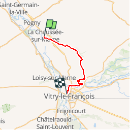
Trail Walking of 22 km to be discovered at Grand Est, Marne, La Chaussée-sur-Marne. This trail is proposed by tracegps.

Description

Le Chemin de Compostelle, voie de Vézelay GR654® présenté par le Comité Régional du Tourisme de Champagne-Ardenne. Chemin de Compostelle, Voie de Vézelay GR654® De La Chaussée sur Marne à Vitry le François. Onzième étape. Vous quittez temporairement la vallée de la Marne pour remonter la vallée du Fion en passant notamment par le beau village de Saint-Amant-sur-Fion. Vous rejoignez ensuite la ville de Vitry-le-François. Vous trouverez le descriptif détaillé de cette randonnée dans le Topo-guide® de la Fédération Française de la Randonnée Pédestre.

Elevation profile

Photos

Positioning

Country:
France
Region :
Grand Est
Department/Province :
Marne
Municipality :
La Chaussée-sur-Marne
Location:
Unknown
Start:(UTM)
611442 ; 5410141 (31U) N.

Trails nearby

Trail Walking Saint-Amand-sur-Fion - Ciruit de Coulvagny -Saint-Amand-sur-Fion - Photo
Walking
tracegps

Walking

Difficult
Saint-Amand-sur-Fion, Grand Est, Marne, France
13.5 km | 15.5 km-effort
3h 25min
Yes
Trail Walking Aulnay-l'Aître - Circuit de Aulnay l'Aître - Photo
Walking
tracegps

Walking

Very difficult
Aulnay-l'Aître, Grand Est, Marne, France
21 km | 25 km-effort
5h 15min
Yes
Trail Walking La Chaussée-sur-Marne - Via Columbani 11-06-2-24 du 16.06.2024 - Photo
Walking
bene_dictus77

Walking

Easy
La Chaussée-sur-Marne, Grand Est, Marne, France
22 km | 25 km-effort
6h 39min
No
Trail Mountain bike Pogny - rando 20km pogny - Photo
Mountain bike
lefebvre jonathan

Mountain bike

Easy
Pogny, Grand Est, Marne, France
18.5 km | 19.5 km-effort
1h 30min
Yes
Trail Hybrid bike Soulanges - vdf essai lac du der - Photo
Hybrid bike
jackber

Hybrid bike

Very easy
Soulanges, Grand Est, Marne, France
32 km | 35 km-effort
Unknown
Yes
Trail Mountain bike Pogny - 2014-06-22 09h58m19 - Photo
Mountain bike
Bernard-Leone

Mountain bike

Easy
Pogny, Grand Est, Marne, France
16.8 km | 18 km-effort
1h 14min
Yes


Close
My subscriptions