Trail Walking Condé-sur-Marne - Chemin de Compostelle, Voie de Vézelay GR654® De Condé sur Marne à Châlons en Champagne - Photo

Chemin de Compostelle, Voie de Vézelay GR654® De Condé sur Marne à Châlons en Champagne

 tracegps
tracegps

User

© OpenStreetMap contributors
Length
Length
20 km
Max alt
Max alt
84 m
Uphill gradient
Uphill gradient
100 m
Km-Effort
Km-Effort  
22 km
Min alt
Min alt
71 m
Downhill gradient
Downhill gradient
95 m
Boucle
Boucle
No
Creation date :
2014-12-10 00:00:00.0
Updated on :
2014-12-10 00:00:00.0

(0 Reviews)

Walking
Walking
4h00
Difficulty : Difficult

Scan this QR Code to open this trail in the SityTrail application

FREE GPS app for hiking

Logo SityTrail SityTrail

IGN / Geographical institutes

Download SityTrail from the App Store Download SityTrail from Google Play

Logo SityTrail SityTrail World

The world is yours!

Download SityTrail from the App Store Download SityTrail from Google Play Download SityTrail on Huawei AppGallery

About

Trail Walking of 20 km to be discovered at Grand Est, Marne, Condé-sur-Marne. This trail is proposed by tracegps.

Description

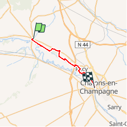
Le Chemin de Compostelle, voie de Vézelay GR654® présenté par le Comité Régional du Tourisme de Champagne-Ardenne. Chemin de Compostelle, Voie de Vézelay GR654® De Condé sur Marne à Châlons en Champagne. Neuvième étape. Cette étape permet de rejoindre Châlons-en-Champagne en suivant la vallée de la Marne. Dans sa grande majorité, le circuit longe le chemin de halage du canal latéral à la Marne. Vous trouverez le descriptif détaillé de cette randonnée dans le Topo-guide® de la Fédération Française de la Randonnée Pédestre.

Elevation profile

Photos

Positioning

Country:
France
Region :
Grand Est
Department/Province :
Marne
Municipality :
Condé-sur-Marne
Location:
Unknown
Start:(UTM)
586373 ; 5433006 (31U) N.

Trails nearby

Trail sport Condé-sur-Marne - Étape 2 Conde/Marne jusqu’à Chatelraould ST.  Lou  - Photo
sport
Roydger

sport

Very easy
(1)
Condé-sur-Marne, Grand Est, Marne, France
74 km | 81 km-effort
Unknown
No
Trail Bicycle tourism Condé-sur-Marne - Condé-Reims 36 km - Photo
Bicycle tourism
GUIDE
jeanmarcMasson

Bicycle tourism

Difficult
Condé-sur-Marne, Grand Est, Marne, France
36 km | 39 km-effort
3h 9min
No
Trail Mountain bike Bouzy - Florent Sabine JP Thierry Arnaud Alain Pascal  - Photo
Mountain bike
pepebru

Mountain bike

Very easy
Bouzy, Grand Est, Marne, France
25 km | 32 km-effort
2h 59min
Yes
Trail Mountain bike Bouzy - 29112020 à 9vtt - Photo
Mountain bike
pepebru

Mountain bike

Easy
Bouzy, Grand Est, Marne, France
27 km | 35 km-effort
2h 9min
Yes
Trail Walking Bouzy - bouzy rando pnr - Photo
Walking
MarieDeBacker

Walking

Medium
Bouzy, Grand Est, Marne, France
8.8 km | 11.7 km-effort
1h 58min
Yes
Trail On foot Bouzy - Champagne_J3_Bouzy_Grauves - Photo
On foot
Magali Phavorin

On foot

Medium
Bouzy, Grand Est, Marne, France
26 km | 30 km-effort
6h 54min
No
Trail On foot Bouzy - Champagne_J3_Bouzy_Cramant - Photo
On foot
Magali Phavorin

On foot

Medium
Bouzy, Grand Est, Marne, France
25 km | 29 km-effort
6h 41min
No
Trail Walking Ambonnay - rando 1 - Photo
Walking
vinovinz

Walking

Easy
Ambonnay, Grand Est, Marne, France
7.1 km | 8.4 km-effort
1h 24min
Yes
Trail Mountain bike Bouzy - JP Virginie Florent Sabine Michel Pascal  - Photo
Mountain bike
pepebru

Mountain bike

Medium
Bouzy, Grand Est, Marne, France
27 km | 34 km-effort
2h 58min
No


Close
My subscriptions