Trail Walking Vienne-le-Château - La Bataille d'Argonne - Photo

La Bataille d'Argonne

 tracegps
tracegps

User

© OpenStreetMap contributors
Length
Length
15.3 km
Max alt
Max alt
223 m
Uphill gradient
Uphill gradient
217 m
Km-Effort
Km-Effort  
18.2 km
Min alt
Min alt
128 m
Downhill gradient
Downhill gradient
218 m
Boucle
Boucle
Yes
Creation date :
2014-12-10 00:00:00.0
Updated on :
2014-12-10 00:00:00.0

(1 Reviews)

Walking
Walking
3h10
Difficulty : Medium

Scan this QR Code to open this trail in the SityTrail application

FREE GPS app for hiking

Logo SityTrail SityTrail

IGN / Geographical institutes

Download SityTrail from the App Store Download SityTrail from Google Play

Logo SityTrail SityTrail World

The world is yours!

Download SityTrail from the App Store Download SityTrail from Google Play Download SityTrail on Huawei AppGallery

About

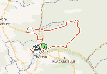
Trail Walking of 15.3 km to be discovered at Grand Est, Marne, Vienne-le-Château. This trail is proposed by tracegps.

Description

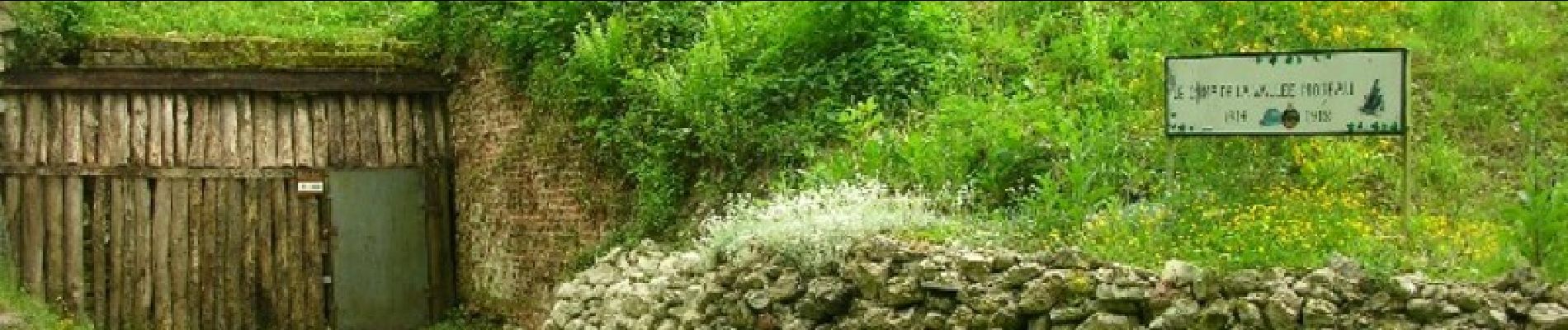
Les Randonnées Thématiques du Comité Régional du Tourisme de Champagne-Ardenne La Bataille d’Argonne Situé au cœur de la grande forêt d’Argonne, cette randonnée vous emmènera dans le théâtre d’une des batailles de la première guerre mondiale. Tout au long du parcours, des monuments, cimetières, vestiges rappellent cette histoire douloureuse. Le paysage forestier est marqué de trous d’obus et jalonnée de tranchées.

Elevation profile

Photos

Positioning

Country:
France
Region :
Grand Est
Department/Province :
Marne
Municipality :
Vienne-le-Château
Location:
Unknown
Start:(UTM)
637465 ; 5450437 (31U) N.

Comments

Please log in to post a review or rate the element


Trails nearby

Trail Walking Vienne-le-Château - SNS VIENNE LE CHÂTEAU 2019 - Photo
Walking
Patrick Martinus

Walking

Difficult
Vienne-le-Château, Grand Est, Marne, France
15.2 km | 18.2 km-effort
3h 57min
Yes
Trail Walking Vienne-le-Château - balade en argone - Photo
Walking
olivier77580

Walking

Very easy
Vienne-le-Château, Grand Est, Marne, France
12.7 km | 15.3 km-effort
4h 18min
Yes
Trail Walking Servon-Melzicourt - servon - Photo
Walking
bt51

Walking

Very easy
Servon-Melzicourt, Grand Est, Marne, France
73 km | 81 km-effort
3h 50min
No
Trail Walking Servon-Melzicourt - hauzy - Photo
Walking
bt51

Walking

Very easy
Servon-Melzicourt, Grand Est, Marne, France
4.6 km | 5 km-effort
1h 32min
Yes
Trail Nordic walking Vienne-le-Château - 30-01 - Photo
Nordic walking
DaVinci

Nordic walking

Easy
Vienne-le-Château, Grand Est, Marne, France
16.9 km | 20 km-effort
2h 29min
No
Trail Nordic walking Servon-Melzicourt - Camp Moreau - Photo
Nordic walking
Divio

Nordic walking

Medium
Servon-Melzicourt, Grand Est, Marne, France
15.1 km | 17.7 km-effort
3h 0min
Yes


Close
My subscriptions