![](/images/other/stat-length.png)
![Trail Walking Guerlesquin - De Guerlesquin à la forêt de Beffou - Photo](https://media.geolcdn.com/t/1900/400/ext.pjpeg?maxdim=2&url=https%3A%2F%2Fstatic1.geolcdn.com%2Fsiteimages%2Fupload%2Ffiles%2F1553511878bg_sport_marche.png)
De Guerlesquin à la forêt de Beffou
tracegps
User
![Length](/images/other/stat-length.png)
![Max alt](https://static1.geolcdn.com/siteimages/upload/files/1508320355ic_sort_altitude_max_24dp.png)
![Uphill gradient](https://static1.geolcdn.com/siteimages/upload/files/1508320355ic_sort_den_pos_24dp.png)
![Km-Effort](/images/other/stat-length.png)
![Min alt](https://static1.geolcdn.com/siteimages/upload/files/1508320355ic_sort_altitude_min_24dp.png)
![Downhill gradient](https://static1.geolcdn.com/siteimages/upload/files/1508320355ic_sort_den_neg_24dp.png)
![Boucle](https://static1.geolcdn.com/siteimages/upload/files/16400158638029165_repeat_loop_refresh_sync_direction_icon.png)
![Walking](https://static1.geolcdn.com/sitytour/trail-icons/101.png)
8h00
Difficulty : Very difficult
![Scan this QR Code to open this trail in the SityTrail application](https://capi.geolives.com/qq0zvz2zws4bq2lad0pu/sitytour/trails/109361/qr.png?size=200)
FREE GPS app for hiking
About
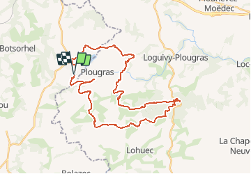
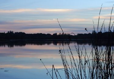
Trail Walking of 36 km to be discovered at Brittany, Finistère, Guerlesquin. This trail is proposed by tracegps.
Description
Sur les Sentiers du Finistère - De Guerlesquin à la forêt de Beffou. Sur Sentier Côtier, retrouvez les sentiers du Finistère à travers des parcours que Thierry et Françoise ont effectués. Numérisation des circuits réalisée sur le terrain. Au sud du village de Loguivy-Plougras s’étend, sur 620 hectares, la forêt de Beffou. Ce massif boisé est une véritable mosaïque de sentiers et d’essences, principalement de feuillus. L’essence la plus présente est le hêtre, puis viennent le chêne, le frêne, le merisier ou le bouleau. Divisée en 45 parcelles, la forêt offre de multiples chemins de promenades. Deux routes traversent le massif : la route reliant Loguivy-Plougras à Callac et une ancienne voie romaine. En bordure de celle-ci se trouve le Pavé (322m d’altitude) qui est le point culminant du Trégor. Le randonneur pourra aussi découvrir l’étang des Comprejou qui abrite un hôte difficile à observer : la loutre. En bordure de la forêt, non loin de la route reliant Plougras à Callac, se trouve l’allée couverte du Brohet, un monument mégalithique datant du 3ème millénaire avant J.C..( Source Tregor.fr ) Mise en garde de l’auteur : parfois des propriétés se construisent, des terrains deviennent inaccessibles ou des sentiers disparaissent faute d'être entretenus. Il faut donc quelquefois, même avec un GPS, improviser et modifier sa route pour ne pas fâcher un nouveau propriétaire récalcitrant. Ceux qui parcourent les chemins sont responsables de leur parcours et le tracé reste indicatif.
Positioning
Comments
Trails nearby
![Trail Walking Plougras - Autour de Plougras, abord de Guerlesquin - Photo](https://media.geolcdn.com/t/375/260/a8b09fd5-9992-462e-8ed5-e1e4f5c9f890.jpg&format=jpg&maxdim=2)
![Walking Walking](https://static1.geolcdn.com/sitytour/trail-icons/101.png)
Walking
![](/images/other/stat-length.png)
![](https://static1.geolcdn.com/siteimages/upload/files/16400158638029165_repeat_loop_refresh_sync_direction_icon.png)
![Trail On foot Guerlesquin - L'Étang du Guic - Photo](https://media.geolcdn.com/t/375/260/e37d09e2-5e71-44c7-8599-762e549e8bd0.jpeg&format=jpg&maxdim=2)
![On foot On foot](https://static1.geolcdn.com/sitytour/trail-icons/100.png)
On foot
![](/images/other/stat-length.png)
![](https://static1.geolcdn.com/siteimages/upload/files/16400158638029165_repeat_loop_refresh_sync_direction_icon.png)
![Trail Walking Botsorhel - Sentiers buissonniers à Botsorhel - Photo](https://media.geolcdn.com/t/375/260/ext.jpg?maxdim=2&url=https%3A%2F%2Fservices.sitytrail.com%2FGeolivesWS%2FDownloadMedia.ashx%3FTrailID%3D191648%26Media%3D15299_6.jpg)
![Walking Walking](https://static1.geolcdn.com/sitytour/trail-icons/101.png)
Walking
![](/images/other/stat-length.png)
![](https://static1.geolcdn.com/siteimages/upload/files/16400158638029165_repeat_loop_refresh_sync_direction_icon.png)
![Trail Walking Plougras - Eoliennes et étang de Beffou - Plougras - Photo](https://media.geolcdn.com/t/375/260/ext.jpg?maxdim=2&url=https%3A%2F%2Fservices.sitytrail.com%2FGeolivesWS%2FDownloadMedia.ashx%3FTrailID%3D105822%26Media%3D9760_4.jpg)
![Walking Walking](https://static1.geolcdn.com/sitytour/trail-icons/101.png)
Walking
![](/images/other/stat-length.png)
![](https://static1.geolcdn.com/siteimages/upload/files/16400158638029165_repeat_loop_refresh_sync_direction_icon.png)
![Trail On foot Botsorhel - Botshorel Morlaix - Photo](https://media.geolcdn.com/t/375/260/ext.jpg?maxdim=2&url=https%3A%2F%2Fstatic1.geolcdn.com%2Fsiteimages%2Fupload%2Ffiles%2F1545311037marcheuse_200dpi.jpg)
![On foot On foot](https://static1.geolcdn.com/sitytour/trail-icons/100.png)
On foot
![](/images/other/stat-length.png)
![](https://static1.geolcdn.com/siteimages/upload/files/16400158638029165_repeat_loop_refresh_sync_direction_icon.png)
![Trail On foot Botsorhel - 2022-04-02_21h02m45_SityTrail - 3150665 - et5xbotsorhelxmorlaix - Photo](https://media.geolcdn.com/t/375/260/ext.jpg?maxdim=2&url=https%3A%2F%2Fstatic1.geolcdn.com%2Fsiteimages%2Fupload%2Ffiles%2F1545311037marcheuse_200dpi.jpg)
![On foot On foot](https://static1.geolcdn.com/sitytour/trail-icons/100.png)
On foot
![](/images/other/stat-length.png)
![](https://static1.geolcdn.com/siteimages/upload/files/16400158638029165_repeat_loop_refresh_sync_direction_icon.png)
![Trail Walking Plougras - Tro ar Guic - Plougras - Photo](https://media.geolcdn.com/t/375/260/ext.jpg?maxdim=2&url=https%3A%2F%2Fservices.sitytrail.com%2FGeolivesWS%2FDownloadMedia.ashx%3FTrailID%3D105909%26Media%3D9927_2.jpg)
![Walking Walking](https://static1.geolcdn.com/sitytour/trail-icons/101.png)
Walking
![](/images/other/stat-length.png)
![](https://static1.geolcdn.com/siteimages/upload/files/16400158638029165_repeat_loop_refresh_sync_direction_icon.png)
![Trail Walking Botsorhel - 29_Botsorhel - Photo](https://media.geolcdn.com/t/375/260/ext.jpg?maxdim=2&url=https%3A%2F%2Fstatic1.geolcdn.com%2Fsiteimages%2Fupload%2Ffiles%2F1553511878bg_sport_marche.png)
![Walking Walking](https://static1.geolcdn.com/sitytour/trail-icons/101.png)
Walking
![](/images/other/stat-length.png)
![](https://static1.geolcdn.com/siteimages/upload/files/16400158638029165_repeat_loop_refresh_sync_direction_icon.png)
![Trail Walking Plougras - Autour de l''étang du Guic - Guerlesquin - Photo](https://media.geolcdn.com/t/375/260/ext.jpg?maxdim=2&url=https%3A%2F%2Fservices.sitytrail.com%2FGeolivesWS%2FDownloadMedia.ashx%3FTrailID%3D215270%26Media%3D15562_1.jpg)
![Walking Walking](https://static1.geolcdn.com/sitytour/trail-icons/101.png)
Walking
![](/images/other/stat-length.png)
![](https://static1.geolcdn.com/siteimages/upload/files/16400158638029165_repeat_loop_refresh_sync_direction_icon.png)