Trail Walking Plougonven - De Morlaix à St Eutrope - Photo

De Morlaix à St Eutrope

 tracegps
tracegps

User

© OpenStreetMap contributors
Length
Length
20 km
Max alt
Max alt
139 m
Uphill gradient
Uphill gradient
350 m
Km-Effort
Km-Effort  
25 km
Min alt
Min alt
25 m
Downhill gradient
Downhill gradient
350 m
Boucle
Boucle
Yes
Creation date :
2014-12-10 00:00:00.0
Updated on :
2014-12-10 00:00:00.0

(0 Reviews)

Walking
Walking
4h30
Difficulty : Difficult

Scan this QR Code to open this trail in the SityTrail application

FREE GPS app for hiking

Logo SityTrail SityTrail

IGN / Geographical institutes

Download SityTrail from the App Store Download SityTrail from Google Play

Logo SityTrail SityTrail World

The world is yours!

Download SityTrail from the App Store Download SityTrail from Google Play Download SityTrail on Huawei AppGallery

About

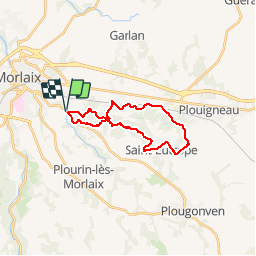
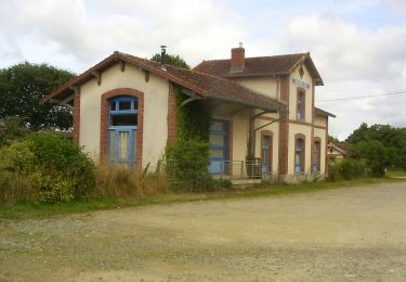
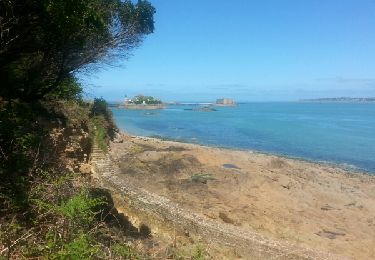
Trail Walking of 20 km to be discovered at Brittany, Finistère, Plougonven. This trail is proposed by tracegps.

Description

Sur les Sentiers du Finistère - De Morlaix à St Eutrope. Sur Sentier Côtier, retrouvez les sentiers du Finistère à travers des parcours que Thierry et Françoise ont effectués. Numérisation des circuits réalisée sur le terrain. La commune de Plougonven est située dans le Trégor Finistérien, au sud-est de l’agglomération Morlaisienne. D’une population proche de 3200 habitants et très étendue - près de 7000 ha - la commune s’étire entre le bassin Morlaisien et les Monts d’Arrée puisqu’elle comprend dans sa partie sud les contreforts du massif armoricain qui culmine à 384 mètres. Mise en garde de l’auteur : parfois des propriétés se construisent, des terrains deviennent inaccessibles ou des sentiers disparaissent faute d'être entretenus. Il faut donc quelquefois, même avec un GPS, improviser et modifier sa route pour ne pas fâcher un nouveau propriétaire récalcitrant. Ceux qui parcourent les chemins sont responsables de leur parcours et le tracé reste indicatif.

Elevation profile

Positioning

Country:
France
Region :
Brittany
Department/Province :
Finistère
Municipality :
Plougonven
Location:
Unknown
Start:(UTM)
441004 ; 5379571 (30U) N.

Trails nearby

Trail Walking Saint-Martin-des-Champs - 29.08.23  Morlaix -- Carantec - Photo
Walking
donda

Walking

Very difficult
Saint-Martin-des-Champs, Brittany, Finistère, France
22 km | 28 km-effort
6h 16min
No
Trail On foot Saint-Martin-des-Champs - Vallée de la Pennélé - Photo
On foot
PRO

On foot

Easy
Saint-Martin-des-Champs, Brittany, Finistère, France
6.5 km | 7.9 km-effort
1h 48min
No
Trail On foot Plougonven - Boucle de Coatanscour - Photo
On foot
PRO

On foot

Easy
Plougonven, Brittany, Finistère, France
9.2 km | 10.9 km-effort
2h 28min
Yes
Trail On foot Plougonven - Boucle de Golodic - Photo
On foot
PRO

On foot

Easy
Plougonven, Brittany, Finistère, France
6.9 km | 8.4 km-effort
1h 54min
Yes
Trail Walking Saint-Martin-des-Champs - Bretagne Nord J4 De Morlaix à Plougasnou - Photo
Walking
chessyca

Walking

Medium
Saint-Martin-des-Champs, Brittany, Finistère, France
25 km | 30 km-effort
5h 51min
No
Trail Walking Morlaix - Bretagne nord J3 pm Visite de Morlaix - Photo
Walking
chessyca

Walking

Very easy
Morlaix, Brittany, Finistère, France
6 km | 7.5 km-effort
2h 0min
No
Trail Walking Saint-Martin-des-Champs - GR 34 étape 24 - Photo
Walking
lagardienne

Walking

Easy
Saint-Martin-des-Champs, Brittany, Finistère, France
28 km | 36 km-effort
8h 32min
No
Trail Bicycle tourism Morlaix - De Morlaix à l'île Callot - Photo
Bicycle tourism
ilur56

Bicycle tourism

Medium
Morlaix, Brittany, Finistère, France
41 km | 48 km-effort
5h 36min
No
Trail Walking Morlaix - GR 34® de Morlaix à Carantec - Photo
Walking
tracegps

Walking

Difficult
Morlaix, Brittany, Finistère, France
26 km | 33 km-effort
5h 40min
No


Close
My subscriptions