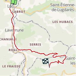
![](/images/other/stat-length.png)
![Trail Walking Luc - Chemin de Stevenson - Luc vers Notre Dame des Neiges - Photo](https://media.geolcdn.com/t/1900/400/ext.pjpeg?maxdim=2&url=https%3A%2F%2Fservices.sitytrail.com%2FGeolivesWS%2FDownloadMedia.ashx%3FTrailID%3D109269%26Media%3D3389_1.jpg)
Chemin de Stevenson - Luc vers Notre Dame des Neiges
tracegps
User
![Length](/images/other/stat-length.png)
![Max alt](https://static1.geolcdn.com/siteimages/upload/files/1508320355ic_sort_altitude_max_24dp.png)
![Uphill gradient](https://static1.geolcdn.com/siteimages/upload/files/1508320355ic_sort_den_pos_24dp.png)
![Km-Effort](/images/other/stat-length.png)
![Min alt](https://static1.geolcdn.com/siteimages/upload/files/1508320355ic_sort_altitude_min_24dp.png)
![Downhill gradient](https://static1.geolcdn.com/siteimages/upload/files/1508320355ic_sort_den_neg_24dp.png)
![Boucle](https://static1.geolcdn.com/siteimages/upload/files/16400158638029165_repeat_loop_refresh_sync_direction_icon.png)
![Walking](https://static1.geolcdn.com/sitytour/trail-icons/101.png)
2h49
Difficulty : Medium
![Scan this QR Code to open this trail in the SityTrail application](https://capi.geolives.com/qq0zvz2zws4bq2lad0pu/sitytour/trails/109269/qr.png?size=200)
FREE GPS app for hiking
About
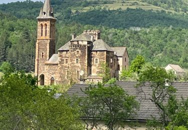
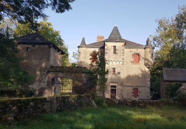
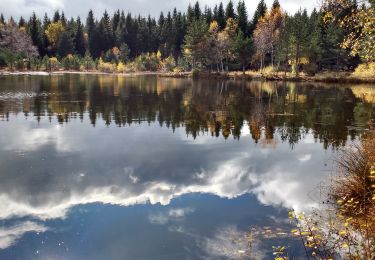
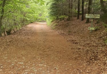
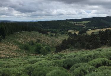
Trail Walking of 12.8 km to be discovered at Occitania, Lozère, Luc. This trail is proposed by tracegps.
Description
Randonnée sur le Chemin de Stevenson à travers la Haute Loire, la Lozère, l'Ardèche et le Gard de l'Auvergne aux Cévennes. Cinquième étape : Luc vers Notre Dame des Neiges Le découpage présenté ici reprend les étapes adoptées par l'écrivain écossais Robert Louis Stevenson. Retrouvez sur le site de l'association Sur le Chemin de Robert Louis Stevenson. toutes les informations nécessaires pour organiser une randonnée sur les pas de Robert Louis Stevenson: hébergement en gîte d'étape, camping, chambre et table d'hôtes, ferme auberge ou hôtel, mais aussi restaurants, location d'âne, organisateurs de randonnée, transport de bagages et de personnes, accompagnateurs de randonnée et informations pratiques.
Positioning
Comments
Trails nearby
![Trail Walking Laveyrune - chemin de Stevenson étape 6 - Photo](https://media.geolcdn.com/t/375/260/03091446-e0a3-452d-a9a6-0e5da8b0e881.jpg&format=jpg&maxdim=2)
![Walking Walking](https://static1.geolcdn.com/sitytour/trail-icons/101.png)
Walking
![](/images/other/stat-length.png)
![](https://static1.geolcdn.com/siteimages/upload/files/16400158638029165_repeat_loop_refresh_sync_direction_icon.png)
![Trail Walking Luc - 5 étape Stevenson - Photo](https://media.geolcdn.com/t/375/260/bce1fbca-ee7b-470a-85b4-41c8101bc81d.jpg&format=jpg&maxdim=2)
![Walking Walking](https://static1.geolcdn.com/sitytour/trail-icons/101.png)
Walking
![](/images/other/stat-length.png)
![](https://static1.geolcdn.com/siteimages/upload/files/16400158638029165_repeat_loop_refresh_sync_direction_icon.png)
![Trail Walking Luc - Une partie du sentier de Stevenson - Photo](https://media.geolcdn.com/t/375/260/bfb9d05e-ae3e-460a-ba5c-c5037b124f03.jpg&format=jpg&maxdim=2)
![Walking Walking](https://static1.geolcdn.com/sitytour/trail-icons/101.png)
Walking
![](/images/other/stat-length.png)
![](https://static1.geolcdn.com/siteimages/upload/files/16400158638029165_repeat_loop_refresh_sync_direction_icon.png)
![Trail Walking Laveyrune - Régordane 3 - Laveyrune-Albespeyre - Photo](https://media.geolcdn.com/t/375/260/759b5a3a-489f-4e3e-9330-e37bebde61d8.jpg&format=jpg&maxdim=2)
![Walking Walking](https://static1.geolcdn.com/sitytour/trail-icons/101.png)
Walking
![](/images/other/stat-length.png)
![](https://static1.geolcdn.com/siteimages/upload/files/16400158638029165_repeat_loop_refresh_sync_direction_icon.png)
![Trail Walking Luc - E5 Luc - La Bastide Puylaurent GR70 - Photo](https://media.geolcdn.com/t/375/260/4c2135f1-c322-41ad-ab46-9046fce45dc1.jpg&format=jpg&maxdim=2)
![Walking Walking](https://static1.geolcdn.com/sitytour/trail-icons/101.png)
Walking
![](/images/other/stat-length.png)
![](https://static1.geolcdn.com/siteimages/upload/files/16400158638029165_repeat_loop_refresh_sync_direction_icon.png)
![Trail Walking Saint-Étienne-de-Lugdarès - Labrot-Bertail-L'Auradou-Luc - Photo](https://media.geolcdn.com/t/375/260/67c66b77-ebb2-4d24-a21b-b39b56d5861f.jpg&format=jpg&maxdim=2)
![Walking Walking](https://static1.geolcdn.com/sitytour/trail-icons/101.png)
Walking
![](/images/other/stat-length.png)
![](https://static1.geolcdn.com/siteimages/upload/files/16400158638029165_repeat_loop_refresh_sync_direction_icon.png)
![Trail Walking Luc - 10-05-2023 E5 Luc - La Bastide Puylaurent - Photo](https://media.geolcdn.com/t/375/260/d54008fb-46e9-42ef-8c51-d54928e19ffd.jpg&format=jpg&maxdim=2)
![Walking Walking](https://static1.geolcdn.com/sitytour/trail-icons/101.png)
Walking
![](/images/other/stat-length.png)
![](https://static1.geolcdn.com/siteimages/upload/files/16400158638029165_repeat_loop_refresh_sync_direction_icon.png)
![Trail Walking Luc - Labeur une chasserades - Photo](https://media.geolcdn.com/t/375/260/90080d69-c0c0-4345-a160-00078b701bc0.jpg&format=jpg&maxdim=2)
![Walking Walking](https://static1.geolcdn.com/sitytour/trail-icons/101.png)
Walking
![](/images/other/stat-length.png)
![](https://static1.geolcdn.com/siteimages/upload/files/16400158638029165_repeat_loop_refresh_sync_direction_icon.png)
![Trail Walking Luc - étape 3 - Photo](https://media.geolcdn.com/t/375/260/49636e18-0a1f-4358-bd50-94a4f06690e4.jpg&format=jpg&maxdim=2)
![Walking Walking](https://static1.geolcdn.com/sitytour/trail-icons/101.png)