![](/images/other/stat-length.png)
![Trail Walking Seix - Le Château de Mirabat par Azas - Photo](https://media.geolcdn.com/t/1900/400/ext.pjpeg?maxdim=2&url=https%3A%2F%2Fservices.sitytrail.com%2FGeolivesWS%2FDownloadMedia.ashx%3FTrailID%3D109210%26Media%3D3289_1.jpg)
Le Château de Mirabat par Azas
tracegps
User
![Length](/images/other/stat-length.png)
![Max alt](https://static1.geolcdn.com/siteimages/upload/files/1508320355ic_sort_altitude_max_24dp.png)
![Uphill gradient](https://static1.geolcdn.com/siteimages/upload/files/1508320355ic_sort_den_pos_24dp.png)
![Km-Effort](/images/other/stat-length.png)
![Min alt](https://static1.geolcdn.com/siteimages/upload/files/1508320355ic_sort_altitude_min_24dp.png)
![Downhill gradient](https://static1.geolcdn.com/siteimages/upload/files/1508320355ic_sort_den_neg_24dp.png)
![Boucle](https://static1.geolcdn.com/siteimages/upload/files/16400158638029165_repeat_loop_refresh_sync_direction_icon.png)
![Walking](https://static1.geolcdn.com/sitytour/trail-icons/101.png)
4h10
Difficulty : Difficult
![Scan this QR Code to open this trail in the SityTrail application](https://capi.geolives.com/qq0zvz2zws4bq2lad0pu/sitytour/trails/109210/qr.png?size=200)
FREE GPS app for hiking
About
Trail Walking of 10.1 km to be discovered at Occitania, Ariège, Seix. This trail is proposed by tracegps.
Description
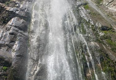
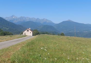
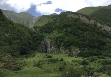
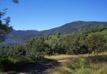
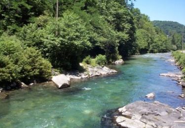
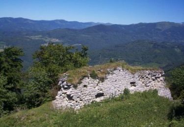
Grand comme trois fois la ville de Paris, le Haut-Couserans se situe au coeur des Pyrénées Ariègeoises à 1h30 de Toulouse. Son environnement naturel et bâtit exceptionnellement préservé, variant de 463m à 2865m, est à découvrir. Le Château de Mirabat par Azas. Belle randonnée utilisant de très bons sentiers à travers la fraîcheur d'une hêtraie ombragée. Le Château datant du 12ème siècle est classé aux monuments historiques. Très belle vue panoramique. De Seix direction Couflens /Salau. Au bout de 2 km et après avoir passé la base de Canoë Kayak, prendre la 1ère piste à gauche qui monte jusqu’au hameau de Azas (Attention au parking, laissez la place pour les demi tour).
Positioning
Comments
Trails nearby
![Trail Walking Seix - 2022 TRANSPYRÉNÉENNE : 6ème etape : Refuge d’Esbints - cabane Aula - Photo](https://media.geolcdn.com/t/375/260/c1446be7-6220-41d3-9aa6-02c934de1eff.jpg&format=jpg&maxdim=2)
![Walking Walking](https://static1.geolcdn.com/sitytour/trail-icons/101.png)
Walking
![](/images/other/stat-length.png)
![](https://static1.geolcdn.com/siteimages/upload/files/16400158638029165_repeat_loop_refresh_sync_direction_icon.png)
![Trail Walking Seix - Cabane d'Aula - Photo](https://media.geolcdn.com/t/375/260/ext.jpg?maxdim=2&url=https%3A%2F%2Fservices.sitytrail.com%2FGeolivesWS%2FDownloadMedia.ashx%3FTrailID%3D834166%26Media%3Dfix__20170824100911.jpg)
![Walking Walking](https://static1.geolcdn.com/sitytour/trail-icons/101.png)
Walking
![](/images/other/stat-length.png)
![](https://static1.geolcdn.com/siteimages/upload/files/16400158638029165_repeat_loop_refresh_sync_direction_icon.png)
![Trail Walking Oust - Serre - Cominac - Photo](https://media.geolcdn.com/t/375/260/6b576f13-3297-4504-ba14-f359b69ea3ee.jpg&format=jpg&maxdim=2)
![Walking Walking](https://static1.geolcdn.com/sitytour/trail-icons/101.png)
![Trail Walking Oust - Estour et Artigue - Photo](https://media.geolcdn.com/t/375/260/f3c35f83-4e48-4874-9beb-953c21b618be.jpg&format=jpg&maxdim=2)
![Walking Walking](https://static1.geolcdn.com/sitytour/trail-icons/101.png)
![Trail Walking Alos - Le Relais du Bouirex - Photo](https://media.geolcdn.com/t/375/260/ext.jpg?maxdim=2&url=https%3A%2F%2Fservices.sitytrail.com%2FGeolivesWS%2FDownloadMedia.ashx%3FTrailID%3D109230%26Media%3D3307_1.jpg)
![Walking Walking](https://static1.geolcdn.com/sitytour/trail-icons/101.png)
Walking
![](/images/other/stat-length.png)
![](https://static1.geolcdn.com/siteimages/upload/files/16400158638029165_repeat_loop_refresh_sync_direction_icon.png)
![Trail Mountain bike Seix - Les bords du Salat à partir de Seix - Photo](https://media.geolcdn.com/t/375/260/ext.jpg?maxdim=2&url=https%3A%2F%2Fservices.sitytrail.com%2FGeolivesWS%2FDownloadMedia.ashx%3FTrailID%3D109229%26Media%3D3306_1.jpg)
![Mountain bike Mountain bike](https://static1.geolcdn.com/sitytour/trail-icons/202.png)
Mountain bike
![](/images/other/stat-length.png)
![](https://static1.geolcdn.com/siteimages/upload/files/16400158638029165_repeat_loop_refresh_sync_direction_icon.png)
![Trail Walking Seix - Les bords du Salat à partir de Seix - Photo](https://media.geolcdn.com/t/375/260/ext.jpg?maxdim=2&url=https%3A%2F%2Fservices.sitytrail.com%2FGeolivesWS%2FDownloadMedia.ashx%3FTrailID%3D109228%26Media%3D3306_1.jpg)
![Walking Walking](https://static1.geolcdn.com/sitytour/trail-icons/101.png)
Walking
![](/images/other/stat-length.png)
![](https://static1.geolcdn.com/siteimages/upload/files/16400158638029165_repeat_loop_refresh_sync_direction_icon.png)
![Trail Walking Oust - Le Château de Mirabat - Photo](https://media.geolcdn.com/t/375/260/ext.jpg?maxdim=2&url=https%3A%2F%2Fservices.sitytrail.com%2FGeolivesWS%2FDownloadMedia.ashx%3FTrailID%3D109209%26Media%3D3288_1.jpg)
![Walking Walking](https://static1.geolcdn.com/sitytour/trail-icons/101.png)
Walking
![](/images/other/stat-length.png)
![](https://static1.geolcdn.com/siteimages/upload/files/16400158638029165_repeat_loop_refresh_sync_direction_icon.png)
![Trail Equestrian Oust - La Serre de Rapheu par le Pas de Sausech - Photo](https://media.geolcdn.com/t/375/260/ext.jpg?maxdim=2&url=https%3A%2F%2Fservices.sitytrail.com%2FGeolivesWS%2FDownloadMedia.ashx%3FTrailID%3D109208%26Media%3D3287_1.jpg)
![Equestrian Equestrian](https://static1.geolcdn.com/sitytour/trail-icons/300.png)
Equestrian
![](/images/other/stat-length.png)
![](https://static1.geolcdn.com/siteimages/upload/files/16400158638029165_repeat_loop_refresh_sync_direction_icon.png)