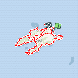
![](/images/other/stat-length.png)
![Trail Walking Ushant - Tour d'Ouessant au - Photo](https://media.geolcdn.com/t/1900/400/ext.pjpeg?maxdim=2&url=https%3A%2F%2Fservices.sitytrail.com%2FGeolivesWS%2FDownloadMedia.ashx%3FTrailID%3D1091788%26Media%3Dfix__20181230150740.jpg)
Tour d'Ouessant au
Balades en Finistère
Promenez-vous au bout du monde !
![Length](/images/other/stat-length.png)
![Max alt](https://static1.geolcdn.com/siteimages/upload/files/1508320355ic_sort_altitude_max_24dp.png)
![Uphill gradient](https://static1.geolcdn.com/siteimages/upload/files/1508320355ic_sort_den_pos_24dp.png)
![Km-Effort](/images/other/stat-length.png)
![Min alt](https://static1.geolcdn.com/siteimages/upload/files/1508320355ic_sort_altitude_min_24dp.png)
![Downhill gradient](https://static1.geolcdn.com/siteimages/upload/files/1508320355ic_sort_den_neg_24dp.png)
![Boucle](https://static1.geolcdn.com/siteimages/upload/files/16400158638029165_repeat_loop_refresh_sync_direction_icon.png)
![Walking](https://static1.geolcdn.com/sitytour/trail-icons/101.png)
13h18
Difficulty : Medium
![Scan this QR Code to open this trail in the SityTrail application](https://capi.geolives.com/qq0zvz2zws4bq2lad0pu/sitytour/trails/1091788/qr.png?size=200)
FREE GPS app for hiking
About
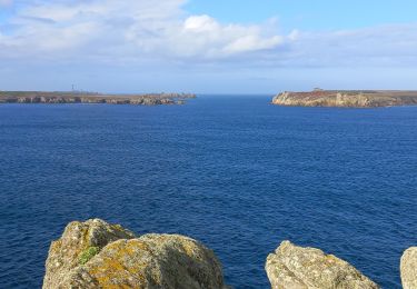
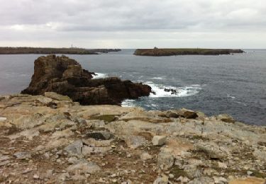
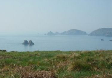
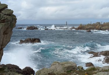
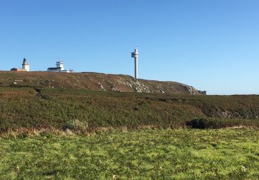
Trail Walking of 50 km to be discovered at Brittany, Finistère, Ushant. This trail is proposed by Balades en Finistère.
Description
Au départ du Stiff, un tour de trois jours à Ouessant en en faisant le tour complet au plus près de la côte.
Attention néanmoins à ne pas suivre la côte de trop près, les risques d'éboulement sont important, il y a plusieurs accidents de ce genre chaque année.
Les points de bivouacs sont nombreux, le ravitaillement en eau n'est possible qu'à Lampaul et au Stiff.
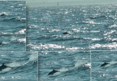
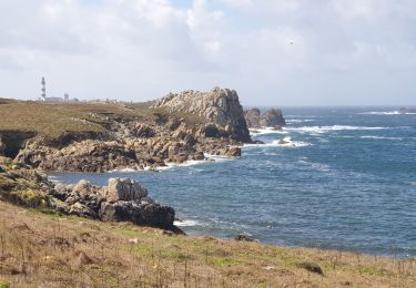
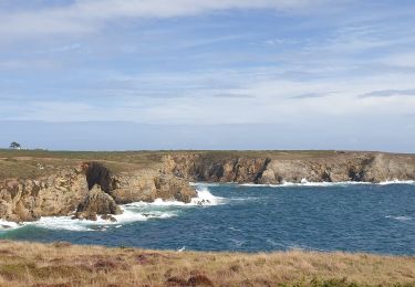
Positioning
Comments
Trails nearby
![Trail Walking Ushant - OUESSANT - Photo](https://media.geolcdn.com/t/375/260/dd2cb79a-8cf5-4140-b9c0-e088dc077526.jpg&format=jpg&maxdim=2)
![Walking Walking](https://static1.geolcdn.com/sitytour/trail-icons/101.png)
![Trail Walking Ushant - Lampaul - Lampaul - Photo](https://media.geolcdn.com/t/375/260/735eea88-441b-4cbf-8486-c86257c9e418.jpg&format=jpg&maxdim=2)
![Walking Walking](https://static1.geolcdn.com/sitytour/trail-icons/101.png)
Walking
![](/images/other/stat-length.png)
![](https://static1.geolcdn.com/siteimages/upload/files/16400158638029165_repeat_loop_refresh_sync_direction_icon.png)
![Trail Walking Ushant - Port Ouessant - Lampaul - Photo](https://media.geolcdn.com/t/375/260/dd1f64a7-7b2a-4ab0-b289-7db55f2cc849.jpg&format=jpg&maxdim=2)
![Walking Walking](https://static1.geolcdn.com/sitytour/trail-icons/101.png)
Walking
![](/images/other/stat-length.png)
![](https://static1.geolcdn.com/siteimages/upload/files/16400158638029165_repeat_loop_refresh_sync_direction_icon.png)
![Trail Walking Ushant - Côte Nord de l'ïle d'Ouessant - Photo](https://media.geolcdn.com/t/375/260/06660439-6893-4e8d-8d37-f3d6f81e76d9.jpg&format=jpg&maxdim=2)
![Walking Walking](https://static1.geolcdn.com/sitytour/trail-icons/101.png)
Walking
![](/images/other/stat-length.png)
![](https://static1.geolcdn.com/siteimages/upload/files/16400158638029165_repeat_loop_refresh_sync_direction_icon.png)
![Trail Walking Ushant - houassan île - Photo](https://media.geolcdn.com/t/375/260/ext.jpg?maxdim=2&url=https%3A%2F%2Fstatic1.geolcdn.com%2Fsiteimages%2Fupload%2Ffiles%2F1553511878bg_sport_marche.png)
![Walking Walking](https://static1.geolcdn.com/sitytour/trail-icons/101.png)
Walking
![](/images/other/stat-length.png)
![](https://static1.geolcdn.com/siteimages/upload/files/16400158638029165_repeat_loop_refresh_sync_direction_icon.png)
![Trail Other activity Ushant - 121107 Ouessant - Photo](https://media.geolcdn.com/t/375/260/ext.jpg?maxdim=2&url=https%3A%2F%2Fservices.sitytrail.com%2FGeolivesWS%2FDownloadMedia.ashx%3FTrailID%3D161803%26Media%3D20121107151847.jpg)
![Other activity Other activity](https://static1.geolcdn.com/sitytour/trail-icons/900.png)
Other activity
![](/images/other/stat-length.png)
![](https://static1.geolcdn.com/siteimages/upload/files/16400158638029165_repeat_loop_refresh_sync_direction_icon.png)
![Trail Walking Ushant - Ile d'Ouessant - rando gps - Photo](https://media.geolcdn.com/t/375/260/ext.jpg?maxdim=2&url=https%3A%2F%2Fservices.sitytrail.com%2FGeolivesWS%2FDownloadMedia.ashx%3FTrailID%3D101374%26Media%3D1121_3.jpg)
![Walking Walking](https://static1.geolcdn.com/sitytour/trail-icons/101.png)
Walking
![](/images/other/stat-length.png)
![](https://static1.geolcdn.com/siteimages/upload/files/16400158638029165_repeat_loop_refresh_sync_direction_icon.png)
![Trail Walking Ushant - Pointe de Pern à Ouessant - Photo](https://media.geolcdn.com/t/375/260/f4230dd3-28a0-4360-a360-b4535fb3ff0f.jpg&format=jpg&maxdim=2)
![Walking Walking](https://static1.geolcdn.com/sitytour/trail-icons/101.png)
Walking
![](/images/other/stat-length.png)
![](https://static1.geolcdn.com/siteimages/upload/files/16400158638029165_repeat_loop_refresh_sync_direction_icon.png)
![Trail Running Ushant - Île d’Ouessant-20092019 - Photo](https://media.geolcdn.com/t/375/260/3e6955f2-161a-42fa-ab6d-55561f29f168.jpg&format=jpg&maxdim=2)
![Running Running](https://static1.geolcdn.com/sitytour/trail-icons/103.png)
Running
![](/images/other/stat-length.png)
![](https://static1.geolcdn.com/siteimages/upload/files/16400158638029165_repeat_loop_refresh_sync_direction_icon.png)
text