Trail Walking Ustou - Les Cascades du chemin d'Espagne - Photo

Les Cascades du chemin d'Espagne

 tracegps
tracegps

User

© OpenStreetMap contributors
Length
Length
8.1 km
Max alt
Max alt
1140 m
Uphill gradient
Uphill gradient
374 m
Km-Effort
Km-Effort  
13.1 km
Min alt
Min alt
767 m
Downhill gradient
Downhill gradient
374 m
Boucle
Boucle
Yes
Creation date :
2014-12-10 00:00:00.0
Updated on :
2014-12-10 00:00:00.0

(1 Reviews)

Walking
Walking
2h30
Difficulty : Medium

Scan this QR Code to open this trail in the SityTrail application

FREE GPS app for hiking

Logo SityTrail SityTrail

IGN / Geographical institutes

Download SityTrail from the App Store Download SityTrail from Google Play

Logo SityTrail SityTrail World

The world is yours!

Download SityTrail from the App Store Download SityTrail from Google Play Download SityTrail on Huawei AppGallery

About

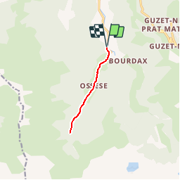
Trail Walking of 8.1 km to be discovered at Occitania, Ariège, Ustou. This trail is proposed by tracegps.

Description

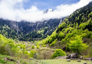
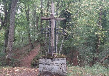
Grand comme trois fois la ville de Paris, le Haut-Couserans se situe au coeur des Pyrénées Ariègeoises à 1h30 de Toulouse. Son environnement naturel et bâtit exceptionnellement préservé, variant de 463m à 2865m, est à découvrir. Les Cascades du chemin d’Espagne. Plusieurs cascades et des gorges. De Seix, direction Guzet Neige. Après Le Trein, prendre à droite direction Saint Lizier, traverser le village puis les hameaux de Portet, l’Arial et Bidous ; départ 500m après ce dernier au niveau d’une croix de fer.

Elevation profile

Photos

Positioning

Country:
France
Region :
Occitania
Department/Province :
Ariège
Municipality :
Ustou
Location:
Unknown
Start:(UTM)
358397 ; 4737691 (31T) N.

Comments

Please log in to post a review or rate the element


facile et agréable avec de magnifiques cascades, la plus belle est la dernière


Trails nearby

Trail Walking Ustou - Col de serre - Photo
Walking
georghinio

Walking

(1)
Ustou, Occitania, Ariège, France
6.3 km | 13.6 km-effort
1h 56min
Yes
Trail Walking Ustou - Le tour de la cabane d'Ardio - Photo
Walking
tracegps

Walking

Medium
(1)
Ustou, Occitania, Ariège, France
4.4 km | 7.1 km-effort
1h 30min
Yes
Trail Walking Ustou - Alet lacarde - Photo
Walking
georghinio

Walking

Very difficult
Ustou, Occitania, Ariège, France
13.3 km | 30 km-effort
6h 22min
Yes
Trail On foot Ustou - Le cirque de Cagateille - Photo
On foot
PRO

On foot

Medium
Ustou, Occitania, Ariège, France
11.1 km | 26 km-effort
5h 49min
Yes
Trail On foot Ustou - Pic de Couillac par le cirque de Cagateille - Photo
On foot
PRO

On foot

Difficult
Ustou, Occitania, Ariège, France
16.3 km | 39 km-effort
8h 52min
Yes
Trail Walking Ustou - Cagateille - Certascan - Photo
Walking
ARVIEU

Walking

Very difficult
Ustou, Occitania, Ariège, France
10.4 km | 29 km-effort
8h 0min
No
Trail Walking Ustou - 2022 TRANSPYRÉNÉEN - St Lizier -d’Ustou -Aulus les Bains - Photo
Walking
LEGUE

Walking

Very difficult
Ustou, Occitania, Ariège, France
17.5 km | 33 km-effort
4h 40min
No
Trail Walking Ustou - Turguilla etang reglisse - Photo
Walking
georghinio

Walking

Medium
Ustou, Occitania, Ariège, France
3.7 km | 7.3 km-effort
2h 48min
No
Trail Nordic walking Ustou - Combes de criespie - Photo
Nordic walking
georghinio

Nordic walking

Easy
Ustou, Occitania, Ariège, France
4.6 km | 8 km-effort
2h 18min
Yes


Close
My subscriptions