![](/images/other/stat-length.png)
![Trail Walking Leers - Circuit des 2 Leers - Photo](https://media.geolcdn.com/t/1900/400/ext.pjpeg?maxdim=2&url=https%3A%2F%2Fservices.sitytrail.com%2FGeolivesWS%2FDownloadMedia.ashx%3FTrailID%3D109002%26Media%3D2943_6.jpg)
Circuit des 2 Leers
tracegps
User
![Length](/images/other/stat-length.png)
Length
10.7 km
![Max alt](https://static1.geolcdn.com/siteimages/upload/files/1508320355ic_sort_altitude_max_24dp.png)
Max alt
30 m
![Uphill gradient](https://static1.geolcdn.com/siteimages/upload/files/1508320355ic_sort_den_pos_24dp.png)
Uphill gradient
49 m
![Km-Effort](/images/other/stat-length.png)
Km-Effort
11.3 km
![Min alt](https://static1.geolcdn.com/siteimages/upload/files/1508320355ic_sort_altitude_min_24dp.png)
Min alt
15 m
![Downhill gradient](https://static1.geolcdn.com/siteimages/upload/files/1508320355ic_sort_den_neg_24dp.png)
Downhill gradient
49 m
![Boucle](https://static1.geolcdn.com/siteimages/upload/files/16400158638029165_repeat_loop_refresh_sync_direction_icon.png)
Boucle
Yes
Creation date :
2014-12-10 00:00:00.0
Updated on :
2014-12-10 00:00:00.0
![Walking](https://static1.geolcdn.com/sitytour/trail-icons/101.png)
2h45
Difficulty : Medium
![Scan this QR Code to open this trail in the SityTrail application](https://capi.geolives.com/qq0zvz2zws4bq2lad0pu/sitytour/trails/109002/qr.png?size=200)
FREE GPS app for hiking
About
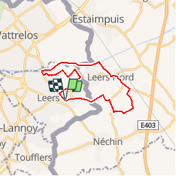
Trail Walking of 10.7 km to be discovered at Hauts-de-France, Nord, Leers. This trail is proposed by tracegps.
Description
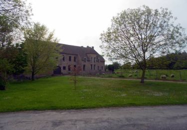
Départ de l’église St-Vaast à Leers (F). Ce circuit transfrontalier qui relie Leers (F) et Leers-Nord (B) traverse la plaine du Ferrain par de petites routes et chemins. Le retour se fait par le canal de Roubaix. Retrouvez ce circuit sur le site du Comité Départemental du Tourisme du Nord.
Positioning
Country:
France
Region :
Hauts-de-France
Department/Province :
Nord
Municipality :
Leers
Location:
Unknown
Start:(Dec)
Start:(UTM)
517525 ; 5614257 (31U) N.
Comments
Trails nearby
![Trail Walking Estaimpuis - Du canal de l'Espierre à Estaimpuis - Photo](https://media.geolcdn.com/t/375/260/ext.jpg?maxdim=2&url=https%3A%2F%2Fstatic1.geolcdn.com%2Fsiteimages%2Fupload%2Ffiles%2F1553511878bg_sport_marche.png)
![Walking Walking](https://static1.geolcdn.com/sitytour/trail-icons/101.png)
Du canal de l'Espierre à Estaimpuis
Walking
Easy
(1)
Estaimpuis,
Wallonia,
Hainaut,
Belgium
![](/images/other/stat-length.png)
7.2 km | 7.7 km-effort
1h 41min
![](https://static1.geolcdn.com/siteimages/upload/files/16400158638029165_repeat_loop_refresh_sync_direction_icon.png)
Yes
![Trail Walking Leers - Leers 9,7 km - Photo](https://media.geolcdn.com/t/375/260/cb250f5b-7759-45c5-a6ff-3bcb89408c74.jpg&format=jpg&maxdim=2)
![Walking Walking](https://static1.geolcdn.com/sitytour/trail-icons/101.png)
![Trail Walking Wattrelos - Sentier de la martelotte - Photo](https://media.geolcdn.com/t/375/260/ext.jpg?maxdim=2&url=https%3A%2F%2Fstatic1.geolcdn.com%2Fsiteimages%2Fupload%2Ffiles%2F1553511878bg_sport_marche.png)
![Walking Walking](https://static1.geolcdn.com/sitytour/trail-icons/101.png)
Sentier de la martelotte
Walking
Very easy
(1)
Wattrelos,
Hauts-de-France,
Nord,
France
![](/images/other/stat-length.png)
4.7 km | 5.1 km-effort
57min
![](https://static1.geolcdn.com/siteimages/upload/files/16400158638029165_repeat_loop_refresh_sync_direction_icon.png)
Yes
![Trail Cycle Estaimpuis - Saint-Leger au fil de l'eau - Photo](https://media.geolcdn.com/t/375/260/ext.jpg?maxdim=2&url=https%3A%2F%2Fservices.sitytrail.com%2FGeolivesWS%2FDownloadMedia.ashx%3FTrailID%3D802543%26Media%3Dfix__20170804162749.jpg)
![Cycle Cycle](https://static1.geolcdn.com/sitytour/trail-icons/200.png)
Saint-Leger au fil de l'eau
Cycle
Easy
Estaimpuis,
Wallonia,
Hainaut,
Belgium
![](/images/other/stat-length.png)
21 km | 23 km-effort
1h 54min
![](https://static1.geolcdn.com/siteimages/upload/files/16400158638029165_repeat_loop_refresh_sync_direction_icon.png)
Yes
![Trail Walking Sailly-lez-Lannoy - Circuit de Robigeux - Sailly lez Lannoy - Photo](https://media.geolcdn.com/t/375/260/ext.jpg?maxdim=2&url=https%3A%2F%2Fservices.sitytrail.com%2FGeolivesWS%2FDownloadMedia.ashx%3FTrailID%3D317899%26Media%3D17311_5.jpg)
![Walking Walking](https://static1.geolcdn.com/sitytour/trail-icons/101.png)
Circuit de Robigeux - Sailly lez Lannoy
Walking
Medium
(3)
Sailly-lez-Lannoy,
Hauts-de-France,
Nord,
France
![](/images/other/stat-length.png)
11.3 km | 12.3 km-effort
2h 49min
![](https://static1.geolcdn.com/siteimages/upload/files/16400158638029165_repeat_loop_refresh_sync_direction_icon.png)
Yes
![Trail Cycle Lys-lez-Lannoy - La Patricia Brevet - Lys les Lannoy - Photo](https://media.geolcdn.com/t/375/260/ext.jpg?maxdim=2&url=https%3A%2F%2Fservices.sitytrail.com%2FGeolivesWS%2FDownloadMedia.ashx%3FTrailID%3D129766%26Media%3D13307_1.jpg)
![Cycle Cycle](https://static1.geolcdn.com/sitytour/trail-icons/200.png)
La Patricia Brevet - Lys les Lannoy
Cycle
Medium
Lys-lez-Lannoy,
Hauts-de-France,
Nord,
France
![](/images/other/stat-length.png)
91 km | 101 km-effort
3h 0min
![](https://static1.geolcdn.com/siteimages/upload/files/16400158638029165_repeat_loop_refresh_sync_direction_icon.png)
Yes
![Trail Cycle Roubaix - Brevet André Mille - Asptt Roubaix - Photo](https://media.geolcdn.com/t/375/260/ext.jpg?maxdim=2&url=https%3A%2F%2Fservices.sitytrail.com%2FGeolivesWS%2FDownloadMedia.ashx%3FTrailID%3D118891%26Media%3D13120_1.jpg)
![Cycle Cycle](https://static1.geolcdn.com/sitytour/trail-icons/200.png)
Brevet André Mille - Asptt Roubaix
Cycle
Medium
Roubaix,
Hauts-de-France,
Nord,
France
![](/images/other/stat-length.png)
103 km | 109 km-effort
3h 30min
![](https://static1.geolcdn.com/siteimages/upload/files/16400158638029165_repeat_loop_refresh_sync_direction_icon.png)
Yes
![Trail Mountain bike Roubaix - La Ronde des Rois - Roubaix - Photo](https://media.geolcdn.com/t/375/260/ext.jpg?maxdim=2&url=https%3A%2F%2Fservices.sitytrail.com%2FGeolivesWS%2FDownloadMedia.ashx%3FTrailID%3D107660%26Media%3D12654_1.jpg)
![Mountain bike Mountain bike](https://static1.geolcdn.com/sitytour/trail-icons/202.png)
La Ronde des Rois - Roubaix
Mountain bike
Medium
Roubaix,
Hauts-de-France,
Nord,
France
![](/images/other/stat-length.png)
50 km | 53 km-effort
3h 0min
![](https://static1.geolcdn.com/siteimages/upload/files/16400158638029165_repeat_loop_refresh_sync_direction_icon.png)
No
![Trail Cycle Hem - Lille Mont St Aubert (B) - Photo](https://media.geolcdn.com/t/375/260/ext.jpg?maxdim=2&url=https%3A%2F%2Fservices.sitytrail.com%2FGeolivesWS%2FDownloadMedia.ashx%3FTrailID%3D104862%26Media%3D8371_2.jpg)
![Cycle Cycle](https://static1.geolcdn.com/sitytour/trail-icons/200.png)
Lille Mont St Aubert (B)
Cycle
Medium
Hem,
Hauts-de-France,
Nord,
France
![](/images/other/stat-length.png)
47 km | 52 km-effort
2h 0min
![](https://static1.geolcdn.com/siteimages/upload/files/16400158638029165_repeat_loop_refresh_sync_direction_icon.png)
No
Top