![](/images/other/stat-length.png)
![Trail Mountain bike Guipavas - De l'Elorn à la Penfeld - Photo](https://media.geolcdn.com/t/1900/400/ext.pjpeg?maxdim=2&url=https%3A%2F%2Fstatic1.geolcdn.com%2Fsiteimages%2Fupload%2Ffiles%2F1524743154velo.jpg)
De l'Elorn à la Penfeld
tracegps
User
![Length](/images/other/stat-length.png)
Length
25 km
![Max alt](https://static1.geolcdn.com/siteimages/upload/files/1508320355ic_sort_altitude_max_24dp.png)
Max alt
112 m
![Uphill gradient](https://static1.geolcdn.com/siteimages/upload/files/1508320355ic_sort_den_pos_24dp.png)
Uphill gradient
358 m
![Km-Effort](/images/other/stat-length.png)
Km-Effort
30 km
![Min alt](https://static1.geolcdn.com/siteimages/upload/files/1508320355ic_sort_altitude_min_24dp.png)
Min alt
8 m
![Downhill gradient](https://static1.geolcdn.com/siteimages/upload/files/1508320355ic_sort_den_neg_24dp.png)
Downhill gradient
359 m
![Boucle](https://static1.geolcdn.com/siteimages/upload/files/16400158638029165_repeat_loop_refresh_sync_direction_icon.png)
Boucle
Yes
Creation date :
2014-12-10 00:00:00.0
Updated on :
2014-12-10 00:00:00.0
![Mountain bike](https://static1.geolcdn.com/sitytour/trail-icons/202.png)
2h00
Difficulty : Difficult
![Scan this QR Code to open this trail in the SityTrail application](https://capi.geolives.com/qq0zvz2zws4bq2lad0pu/sitytour/trails/108999/qr.png?size=200)
FREE GPS app for hiking
About
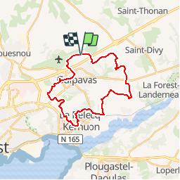
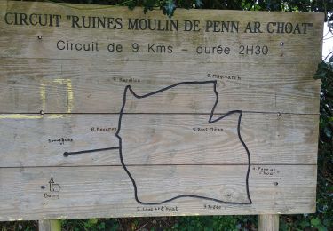
Trail Mountain bike of 25 km to be discovered at Brittany, Finistère, Guipavas. This trail is proposed by tracegps.
Description
Circuit n° 3 de de Brest Métropole Océane Départ du parking de l'aéroport de Brest ou du lieu dit Beg ar Croas à coté de la liaison avec le circuit n°2.
Positioning
Country:
France
Region :
Brittany
Department/Province :
Finistère
Municipality :
Guipavas
Location:
Unknown
Start:(Dec)
Start:(UTM)
396729 ; 5367300 (30U) N.
Comments
Trails nearby
![Trail Walking Kersaint-Plabennec - Coulée verte a Kersaint-Plabennec - Photo](https://media.geolcdn.com/t/375/260/ext.jpg?maxdim=2&url=https%3A%2F%2Fservices.sitytrail.com%2FGeolivesWS%2FDownloadMedia.ashx%3FTrailID%3D210069%26Media%3Dfix__20130804140056.jpg)
![Walking Walking](https://static1.geolcdn.com/sitytour/trail-icons/101.png)
Coulée verte a Kersaint-Plabennec
Walking
Very easy
(1)
Kersaint-Plabennec,
Brittany,
Finistère,
France
![](/images/other/stat-length.png)
2.6 km | 2.8 km-effort
58min
![](https://static1.geolcdn.com/siteimages/upload/files/16400158638029165_repeat_loop_refresh_sync_direction_icon.png)
Yes
![Trail Walking Guipavas - Cotaudon - Brest - Photo](https://media.geolcdn.com/t/375/260/ext.jpg?maxdim=2&url=https%3A%2F%2Fservices.sitytrail.com%2FGeolivesWS%2FDownloadMedia.ashx%3FTrailID%3D109156%26Media%3D3199_1.jpg)
![Walking Walking](https://static1.geolcdn.com/sitytour/trail-icons/101.png)
Cotaudon - Brest
Walking
Medium
(2)
Guipavas,
Brittany,
Finistère,
France
![](/images/other/stat-length.png)
10.8 km | 13.2 km-effort
2h 19min
![](https://static1.geolcdn.com/siteimages/upload/files/16400158638029165_repeat_loop_refresh_sync_direction_icon.png)
Yes
![Trail Nordic walking Guipavas - hôtel cafe chantant st divi guipavas - Photo](https://media.geolcdn.com/t/375/260/1880b21b-949a-4788-b275-62329c398c0c.jpg&format=jpg&maxdim=2)
![Nordic walking Nordic walking](https://static1.geolcdn.com/sitytour/trail-icons/102.png)
hôtel cafe chantant st divi guipavas
Nordic walking
Very easy
Guipavas,
Brittany,
Finistère,
France
![](/images/other/stat-length.png)
13 km | 15.1 km-effort
3h 14min
![](https://static1.geolcdn.com/siteimages/upload/files/16400158638029165_repeat_loop_refresh_sync_direction_icon.png)
Yes
![Trail Walking Brest - Stangalard-Costour - Photo](https://media.geolcdn.com/t/375/260/ext.jpg?maxdim=2&url=https%3A%2F%2Fservices.sitytrail.com%2FGeolivesWS%2FDownloadMedia.ashx%3FTrailID%3D1125537%26Media%3Dfix__20190323111003.jpg)
![Walking Walking](https://static1.geolcdn.com/sitytour/trail-icons/101.png)
Stangalard-Costour
Walking
Easy
Brest,
Brittany,
Finistère,
France
![](/images/other/stat-length.png)
7.6 km | 8.8 km-effort
1h 43min
![](https://static1.geolcdn.com/siteimages/upload/files/16400158638029165_repeat_loop_refresh_sync_direction_icon.png)
Yes
![Trail Walking Guipavas - PR Tour du Douvez Guipavas - Photo](https://media.geolcdn.com/t/375/260/ext.jpg?maxdim=2&url=https%3A%2F%2Fservices.sitytrail.com%2FGeolivesWS%2FDownloadMedia.ashx%3FTrailID%3D882174%26Media%3Dfix__20180101151203.jpg)
![Walking Walking](https://static1.geolcdn.com/sitytour/trail-icons/101.png)
PR Tour du Douvez Guipavas
Walking
Easy
Guipavas,
Brittany,
Finistère,
France
![](/images/other/stat-length.png)
10.5 km | 12.6 km-effort
2h 44min
![](https://static1.geolcdn.com/siteimages/upload/files/16400158638029165_repeat_loop_refresh_sync_direction_icon.png)
Yes
![Trail Walking Saint-Divy - Tour de Saint Divy Est - Photo](https://media.geolcdn.com/t/375/260/4a4d1382-92cd-4ed9-988f-584e62ec0b54.jpg&format=jpg&maxdim=2)
![Walking Walking](https://static1.geolcdn.com/sitytour/trail-icons/101.png)
Tour de Saint Divy Est
Walking
Very easy
(1)
Saint-Divy,
Brittany,
Finistère,
France
![](/images/other/stat-length.png)
9.7 km | 11.3 km-effort
2h 2min
![](https://static1.geolcdn.com/siteimages/upload/files/16400158638029165_repeat_loop_refresh_sync_direction_icon.png)
Yes
![Trail Equestrian Guipavas - De Gupavas à la Forêt de Landerneau - Photo](https://media.geolcdn.com/t/375/260/ext.jpg?maxdim=2&url=https%3A%2F%2Fservices.sitytrail.com%2FGeolivesWS%2FDownloadMedia.ashx%3FTrailID%3D317223%26Media%3D16399_2.jpg)
![Equestrian Equestrian](https://static1.geolcdn.com/sitytour/trail-icons/300.png)
De Gupavas à la Forêt de Landerneau
Equestrian
Medium
Guipavas,
Brittany,
Finistère,
France
![](/images/other/stat-length.png)
31 km | 38 km-effort
3h 0min
![](https://static1.geolcdn.com/siteimages/upload/files/16400158638029165_repeat_loop_refresh_sync_direction_icon.png)
Yes
![Trail Mountain bike Guipavas - De Gupavas à la Forêt de Landerneau - Photo](https://media.geolcdn.com/t/375/260/ext.jpg?maxdim=2&url=https%3A%2F%2Fservices.sitytrail.com%2FGeolivesWS%2FDownloadMedia.ashx%3FTrailID%3D317222%26Media%3D16399_2.jpg)
![Mountain bike Mountain bike](https://static1.geolcdn.com/sitytour/trail-icons/202.png)
De Gupavas à la Forêt de Landerneau
Mountain bike
Medium
Guipavas,
Brittany,
Finistère,
France
![](/images/other/stat-length.png)
31 km | 38 km-effort
2h 30min
![](https://static1.geolcdn.com/siteimages/upload/files/16400158638029165_repeat_loop_refresh_sync_direction_icon.png)
Yes
![Trail Walking Guipavas - Autour de Keraudry près de Guipavas - Photo](https://media.geolcdn.com/t/375/260/ext.jpg?maxdim=2&url=https%3A%2F%2Fservices.sitytrail.com%2FGeolivesWS%2FDownloadMedia.ashx%3FTrailID%3D109353%26Media%3D3639_1.jpg)
![Walking Walking](https://static1.geolcdn.com/sitytour/trail-icons/101.png)
Autour de Keraudry près de Guipavas
Walking
Medium
(1)
Guipavas,
Brittany,
Finistère,
France
![](/images/other/stat-length.png)
10.5 km | 12.3 km-effort
2h 0min
![](https://static1.geolcdn.com/siteimages/upload/files/16400158638029165_repeat_loop_refresh_sync_direction_icon.png)
Yes