![](/images/other/stat-length.png)
![Trail Walking Mons-en-Laonnois - Le panorama des Creuttes - Photo](https://media.geolcdn.com/t/1900/400/ext.pjpeg?maxdim=2&url=https%3A%2F%2Fservices.sitytrail.com%2FGeolivesWS%2FDownloadMedia.ashx%3FTrailID%3D108964%26Media%3D2853_1.jpg)
Le panorama des Creuttes
tracegps
User
![Length](/images/other/stat-length.png)
Length
1.8 km
![Max alt](https://static1.geolcdn.com/siteimages/upload/files/1508320355ic_sort_altitude_max_24dp.png)
Max alt
176 m
![Uphill gradient](https://static1.geolcdn.com/siteimages/upload/files/1508320355ic_sort_den_pos_24dp.png)
Uphill gradient
55 m
![Km-Effort](/images/other/stat-length.png)
Km-Effort
2.5 km
![Min alt](https://static1.geolcdn.com/siteimages/upload/files/1508320355ic_sort_altitude_min_24dp.png)
Min alt
113 m
![Downhill gradient](https://static1.geolcdn.com/siteimages/upload/files/1508320355ic_sort_den_neg_24dp.png)
Downhill gradient
61 m
![Boucle](https://static1.geolcdn.com/siteimages/upload/files/16400158638029165_repeat_loop_refresh_sync_direction_icon.png)
Boucle
Yes
Creation date :
2014-12-10 00:00:00.0
Updated on :
2014-12-10 00:00:00.0
![Walking](https://static1.geolcdn.com/sitytour/trail-icons/101.png)
45m
Difficulty : Medium
![Scan this QR Code to open this trail in the SityTrail application](https://capi.geolives.com/qq0zvz2zws4bq2lad0pu/sitytour/trails/108964/qr.png?size=200)
FREE GPS app for hiking
About
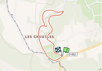
Trail Walking of 1.8 km to be discovered at Hauts-de-France, Aisne, Mons-en-Laonnois. This trail is proposed by tracegps.
Description
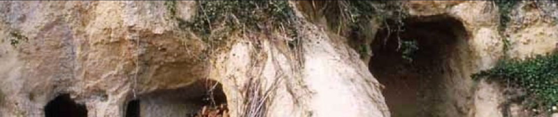
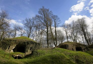
Ce petit circuit emprunte un temps le chemin des Creuttes, offrant de jolies vues sur ces anciennes et étonnantes habitations troglodytiques creusées dans les falaises et les affleurements rocheux. Retrouvez toutes les informations nécessaires ICI
Positioning
Country:
France
Region :
Hauts-de-France
Department/Province :
Aisne
Municipality :
Mons-en-Laonnois
Location:
Unknown
Start:(Dec)
Start:(UTM)
539224 ; 5486870 (31U) N.
Comments
Trails nearby
![Trail Walking Mons-en-Laonnois - Autour du Fort de Laniscourt - Photo](https://media.geolcdn.com/t/375/260/ext.jpg?maxdim=2&url=https%3A%2F%2Fservices.sitytrail.com%2FGeolivesWS%2FDownloadMedia.ashx%3FTrailID%3D102639%26Media%3D3631_5.jpg)
![Walking Walking](https://static1.geolcdn.com/sitytour/trail-icons/101.png)
Autour du Fort de Laniscourt
Walking
Easy
(1)
Mons-en-Laonnois,
Hauts-de-France,
Aisne,
France
![](/images/other/stat-length.png)
5.3 km | 6.2 km-effort
1h 30min
![](https://static1.geolcdn.com/siteimages/upload/files/16400158638029165_repeat_loop_refresh_sync_direction_icon.png)
Yes
![Trail Walking Laon - La Butte de Laon - L'eau de bas en haut - Photo](https://media.geolcdn.com/t/375/260/ext.jpg?maxdim=2&url=https%3A%2F%2Fservices.sitytrail.com%2FGeolivesWS%2FDownloadMedia.ashx%3FTrailID%3D110391%26Media%3D5848_1.jpg)
![Walking Walking](https://static1.geolcdn.com/sitytour/trail-icons/101.png)
La Butte de Laon - L'eau de bas en haut
Walking
Medium
(1)
Laon,
Hauts-de-France,
Aisne,
France
![](/images/other/stat-length.png)
5.4 km | 7.1 km-effort
2h 0min
![](https://static1.geolcdn.com/siteimages/upload/files/16400158638029165_repeat_loop_refresh_sync_direction_icon.png)
Yes
![Trail Walking Chavignon - Chavignon - Du Pont Noir au Bélier - Photo](https://media.geolcdn.com/t/375/260/ext.jpg?maxdim=2&url=https%3A%2F%2Fservices.sitytrail.com%2FGeolivesWS%2FDownloadMedia.ashx%3FTrailID%3D110390%26Media%3D5847_1.jpg)
![Walking Walking](https://static1.geolcdn.com/sitytour/trail-icons/101.png)
Chavignon - Du Pont Noir au Bélier
Walking
Difficult
(1)
Chavignon,
Hauts-de-France,
Aisne,
France
![](/images/other/stat-length.png)
14.5 km | 17.2 km-effort
3h 45min
![](https://static1.geolcdn.com/siteimages/upload/files/16400158638029165_repeat_loop_refresh_sync_direction_icon.png)
Yes
![Trail Walking Cessières-Suzy - randonnée à Cessieres 02 - Photo](https://media.geolcdn.com/t/375/260/a7418132-18cf-4e68-9f94-2b54b4c8b863.jpg&format=jpg&maxdim=2)
![Walking Walking](https://static1.geolcdn.com/sitytour/trail-icons/101.png)
randonnée à Cessieres 02
Walking
Medium
Cessières-Suzy,
Hauts-de-France,
Aisne,
France
![](/images/other/stat-length.png)
12.4 km | 15.3 km-effort
2h 56min
![](https://static1.geolcdn.com/siteimages/upload/files/16400158638029165_repeat_loop_refresh_sync_direction_icon.png)
Yes
![Trail Walking Mons-en-Laonnois - Circuit 10.6 km Détours dans la butte de Mons - Photo](https://media.geolcdn.com/t/375/260/ext.jpg?maxdim=2&url=https%3A%2F%2Fservices.sitytrail.com%2FGeolivesWS%2FDownloadMedia.ashx%3FTrailID%3D654266%26Media%3D42c078d0-cad2-40ef-9ebd-411f313da59e.jpg)
![Walking Walking](https://static1.geolcdn.com/sitytour/trail-icons/101.png)
Circuit 10.6 km Détours dans la butte de Mons
Walking
Very easy
Mons-en-Laonnois,
Hauts-de-France,
Aisne,
France
![](/images/other/stat-length.png)
10.6 km | 13.7 km-effort
2h 56min
![](https://static1.geolcdn.com/siteimages/upload/files/16400158638029165_repeat_loop_refresh_sync_direction_icon.png)
Yes
![Trail Walking Mons-en-Laonnois - Détours dans la butte de Mons - Photo](https://media.geolcdn.com/t/375/260/ext.jpg?maxdim=2&url=https%3A%2F%2Fservices.sitytrail.com%2FGeolivesWS%2FDownloadMedia.ashx%3FTrailID%3D202811%26Media%3D5ae9f6cd-c7eb-4ca7-813a-1495062b4aff.jpg)
![Walking Walking](https://static1.geolcdn.com/sitytour/trail-icons/101.png)
Détours dans la butte de Mons
Walking
Very easy
(1)
Mons-en-Laonnois,
Hauts-de-France,
Aisne,
France
![](/images/other/stat-length.png)
10.6 km | 13.7 km-effort
Unknown
![](https://static1.geolcdn.com/siteimages/upload/files/16400158638029165_repeat_loop_refresh_sync_direction_icon.png)
Yes
![Trail Walking Laon - Le grand tour de Laon - Photo](https://media.geolcdn.com/t/375/260/a02347ad-a9f0-4106-aaad-61da55c5afc3.jpg&format=jpg&maxdim=2)
![Walking Walking](https://static1.geolcdn.com/sitytour/trail-icons/101.png)
Le grand tour de Laon
Walking
Medium
Laon,
Hauts-de-France,
Aisne,
France
![](/images/other/stat-length.png)
7.1 km | 9.1 km-effort
2h 0min
![](https://static1.geolcdn.com/siteimages/upload/files/16400158638029165_repeat_loop_refresh_sync_direction_icon.png)
Yes
![Trail Mountain bike Mons-en-Laonnois - Buttes et marais - Photo](https://media.geolcdn.com/t/375/260/ext.jpg?maxdim=2&url=https%3A%2F%2Fservices.sitytrail.com%2FGeolivesWS%2FDownloadMedia.ashx%3FTrailID%3D108496%26Media%3D1216_2.jpg)
![Mountain bike Mountain bike](https://static1.geolcdn.com/sitytour/trail-icons/202.png)
Buttes et marais
Mountain bike
Very difficult
Mons-en-Laonnois,
Hauts-de-France,
Aisne,
France
![](/images/other/stat-length.png)
28 km | 36 km-effort
4h 0min
![](https://static1.geolcdn.com/siteimages/upload/files/16400158638029165_repeat_loop_refresh_sync_direction_icon.png)
Yes
![Trail Walking Merlieux-et-Fouquerolles - Les arts et les lettres - Photo](https://media.geolcdn.com/t/375/260/ext.jpg?maxdim=2&url=https%3A%2F%2Fservices.sitytrail.com%2FGeolivesWS%2FDownloadMedia.ashx%3FTrailID%3D108380%26Media%3D1064_2.jpg)
![Walking Walking](https://static1.geolcdn.com/sitytour/trail-icons/101.png)
Les arts et les lettres
Walking
Very difficult
Merlieux-et-Fouquerolles,
Hauts-de-France,
Aisne,
France
![](/images/other/stat-length.png)
14.4 km | 17.5 km-effort
4h 0min
![](https://static1.geolcdn.com/siteimages/upload/files/16400158638029165_repeat_loop_refresh_sync_direction_icon.png)
Yes