Trail Walking Authie - Autour du Prieuré d'Authie - Photo

Autour du Prieuré d'Authie

 tracegps
tracegps

User

© OpenStreetMap contributors
Length
Length
10.1 km
Max alt
Max alt
149 m
Uphill gradient
Uphill gradient
141 m
Km-Effort
Km-Effort  
12 km
Min alt
Min alt
75 m
Downhill gradient
Downhill gradient
141 m
Boucle
Boucle
Yes
Creation date :
2014-12-10 00:00:00.0
Updated on :
2014-12-10 00:00:00.0

(1 Reviews)

Walking
Walking
3h19
Difficulty : Medium

Scan this QR Code to open this trail in the SityTrail application

FREE GPS app for hiking

Logo SityTrail SityTrail

IGN / Geographical institutes

Download SityTrail from the App Store Download SityTrail from Google Play

Logo SityTrail SityTrail World

The world is yours!

Download SityTrail from the App Store Download SityTrail from Google Play Download SityTrail on Huawei AppGallery

About

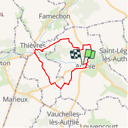
Trail Walking of 10.1 km to be discovered at Hauts-de-France, Somme, Authie. This trail is proposed by tracegps.

Description

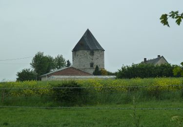
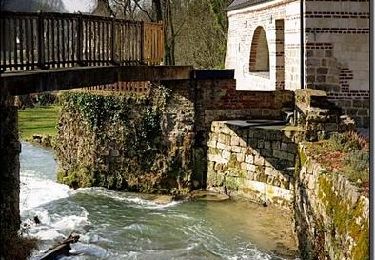
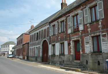
De l'ancien prieuré, découvrir le charme d'un village portant le nom du fleuve côtier qui le traverse.

Elevation profile

Photos

Positioning

Country:
France
Region :
Hauts-de-France
Department/Province :
Somme
Municipality :
Authie
Location:
Unknown
Start:(UTM)
463421 ; 5552241 (31U) N.

Comments

Please log in to post a review or rate the element


très belle randonnée


Trails nearby

Trail On foot Vauchelles-lès-Authie - Circuit du Pigeonnier au Moulin - Photo
On foot
GUIDE+

On foot

Easy
Vauchelles-lès-Authie, Hauts-de-France, Somme, France
6.8 km | 7.7 km-effort
1h 44min
Yes
Trail On foot Authie - Autour du Prieuré d'Authie - Photo
On foot
GUIDE+

On foot

Easy
Authie, Hauts-de-France, Somme, France
10 km | 11.8 km-effort
2h 41min
Yes
Trail Walking Thièvres - Sentier de la montagne - Thièvres - Photo
Walking
tracegps

Walking

Medium
Thièvres, Hauts-de-France, Somme, France
8.7 km | 10.1 km-effort
2h 10min
Yes
Trail Walking Thièvres - Sentier du Fay - Grand-Rullecourt - Photo
Walking
tracegps

Walking

Very difficult
Thièvres, Hauts-de-France, Somme, France
8.7 km | 10.1 km-effort
4h 25min
Yes
Trail Walking Pas-en-Artois - Sentier des Bois - Pas-en-Artois - Photo
Walking
tracegps

Walking

Medium
Pas-en-Artois, Hauts-de-France, Pas-de-Calais, France
8.7 km | 10.7 km-effort
2h 10min
Yes
Trail Walking Thièvres - THIEVRES - Circuit de l'arbre de Cocagne - Photo
Walking
temmichel

Walking

Medium
Thièvres, Hauts-de-France, Pas-de-Calais, France
8.8 km | 10.6 km-effort
2h 24min
Yes
Trail Walking Bus-lès-Artois - 20190607-Bus les Artois - Photo
Walking
doudet

Walking

Medium
Bus-lès-Artois, Hauts-de-France, Somme, France
20 km | 23 km-effort
5h 26min
Yes
Trail Walking Souastre - Souastre - Couin - Coigneux - Photo
Walking
tracegps

Walking

Medium
Souastre, Hauts-de-France, Pas-de-Calais, France
8.8 km | 9.9 km-effort
2h 0min
Yes
Trail Walking Thièvres - kjv - Photo
Walking
a.catteau

Walking

Very easy
Thièvres, Hauts-de-France, Somme, France
9 km | 10.4 km-effort
2h 39min
Yes


Close
My subscriptions