![](/images/other/stat-length.png)
![Trail Walking Terranjou - De vignes en forêt - Notre Dame d'Alençon - Photo](https://media.geolcdn.com/t/1900/400/ext.pjpeg?maxdim=2&url=https%3A%2F%2Fservices.sitytrail.com%2FGeolivesWS%2FDownloadMedia.ashx%3FTrailID%3D108821%26Media%3D2317_2.jpg)
De vignes en forêt - Notre Dame d'Alençon
tracegps
User
![Length](/images/other/stat-length.png)
Length
9.5 km
![Max alt](https://static1.geolcdn.com/siteimages/upload/files/1508320355ic_sort_altitude_max_24dp.png)
Max alt
87 m
![Uphill gradient](https://static1.geolcdn.com/siteimages/upload/files/1508320355ic_sort_den_pos_24dp.png)
Uphill gradient
95 m
![Km-Effort](/images/other/stat-length.png)
Km-Effort
10.8 km
![Min alt](https://static1.geolcdn.com/siteimages/upload/files/1508320355ic_sort_altitude_min_24dp.png)
Min alt
44 m
![Downhill gradient](https://static1.geolcdn.com/siteimages/upload/files/1508320355ic_sort_den_neg_24dp.png)
Downhill gradient
95 m
![Boucle](https://static1.geolcdn.com/siteimages/upload/files/16400158638029165_repeat_loop_refresh_sync_direction_icon.png)
Boucle
Yes
Creation date :
2014-12-10 00:00:00.0
Updated on :
2014-12-10 00:00:00.0
![Walking](https://static1.geolcdn.com/sitytour/trail-icons/101.png)
2h30
Difficulty : Medium
![Scan this QR Code to open this trail in the SityTrail application](https://capi.geolives.com/qq0zvz2zws4bq2lad0pu/sitytour/trails/108821/qr.png?size=200)
FREE GPS app for hiking
About
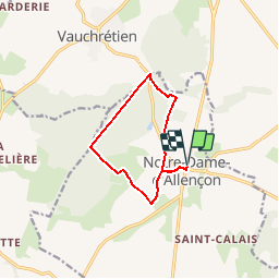
Trail Walking of 9.5 km to be discovered at Pays de la Loire, Maine-et-Loire, Terranjou. This trail is proposed by tracegps.
Description
Parcours en partie au coeur du massif forestier de Brissac, forêt privée appartenant au château de Brissac. Vous serez donc très vigilants quant au respect de cet environnement et de ses sentiers.
Positioning
Country:
France
Region :
Pays de la Loire
Department/Province :
Maine-et-Loire
Municipality :
Terranjou
Location:
Unknown
Start:(Dec)
Start:(UTM)
692854 ; 5242072 (30T) N.
Comments
Trails nearby
![On foot On foot](https://static1.geolcdn.com/sitytour/trail-icons/100.png)
GPS Vauchrétien 10,05 km
On foot
Very easy
Brissac-Loire-Aubance,
Pays de la Loire,
Maine-et-Loire,
France
![](/images/other/stat-length.png)
10 km | 11.2 km-effort
Unknown
![](https://static1.geolcdn.com/siteimages/upload/files/16400158638029165_repeat_loop_refresh_sync_direction_icon.png)
Yes
![Trail Walking Terranjou - Circuit des côteaux - Chavagnes-les-Eaux - Photo](https://media.geolcdn.com/t/375/260/ext.jpg?maxdim=2&url=https%3A%2F%2Fservices.sitytrail.com%2FGeolivesWS%2FDownloadMedia.ashx%3FTrailID%3D106019%26Media%3D10144_5.jpg)
![Walking Walking](https://static1.geolcdn.com/sitytour/trail-icons/101.png)
Circuit des côteaux - Chavagnes-les-Eaux
Walking
Difficult
Terranjou,
Pays de la Loire,
Maine-et-Loire,
France
![](/images/other/stat-length.png)
13.5 km | 14.5 km-effort
3h 25min
![](https://static1.geolcdn.com/siteimages/upload/files/16400158638029165_repeat_loop_refresh_sync_direction_icon.png)
Yes
![Trail Walking Brissac-Loire-Aubance - Vauchrétien - Photo](https://media.geolcdn.com/t/375/260/019bd170-9429-4176-9af7-8964db276523.jpg&format=jpg&maxdim=2)
![Walking Walking](https://static1.geolcdn.com/sitytour/trail-icons/101.png)
Vauchrétien
Walking
Difficult
Brissac-Loire-Aubance,
Pays de la Loire,
Maine-et-Loire,
France
![](/images/other/stat-length.png)
18.3 km | 21 km-effort
3h 4min
![](https://static1.geolcdn.com/siteimages/upload/files/16400158638029165_repeat_loop_refresh_sync_direction_icon.png)
Yes
![Trail On foot Terranjou - De vignes en foret - Photo](https://media.geolcdn.com/t/375/260/ext.jpg?maxdim=2&url=https%3A%2F%2Fstatic1.geolcdn.com%2Fsiteimages%2Fupload%2Ffiles%2F1545311037marcheuse_200dpi.jpg)
![On foot On foot](https://static1.geolcdn.com/sitytour/trail-icons/100.png)
De vignes en foret
On foot
Easy
Terranjou,
Pays de la Loire,
Maine-et-Loire,
France
![](/images/other/stat-length.png)
8.2 km | 9.4 km-effort
2h 7min
![](https://static1.geolcdn.com/siteimages/upload/files/16400158638029165_repeat_loop_refresh_sync_direction_icon.png)
No
![Trail Walking Bellevigne-en-Layon - Thouarcé - Photo](https://media.geolcdn.com/t/375/260/ext.jpg?maxdim=2&url=https%3A%2F%2Fservices.sitytrail.com%2FGeolivesWS%2FDownloadMedia.ashx%3FTrailID%3D535471%26Media%3Dfix__20160308153650.jpg)
![Walking Walking](https://static1.geolcdn.com/sitytour/trail-icons/101.png)
Thouarcé
Walking
Very easy
Bellevigne-en-Layon,
Pays de la Loire,
Maine-et-Loire,
France
![](/images/other/stat-length.png)
8.7 km | 10.1 km-effort
2h 31min
![](https://static1.geolcdn.com/siteimages/upload/files/16400158638029165_repeat_loop_refresh_sync_direction_icon.png)
Yes
![Trail Walking Bellevigne-en-Layon - Le circuit des Moulins - Thouarcé - Photo](https://media.geolcdn.com/t/375/260/ext.jpg?maxdim=2&url=https%3A%2F%2Fservices.sitytrail.com%2FGeolivesWS%2FDownloadMedia.ashx%3FTrailID%3D108827%26Media%3D2328_1.jpg)
![Walking Walking](https://static1.geolcdn.com/sitytour/trail-icons/101.png)
Le circuit des Moulins - Thouarcé
Walking
Medium
(1)
Bellevigne-en-Layon,
Pays de la Loire,
Maine-et-Loire,
France
![](/images/other/stat-length.png)
8.7 km | 10.1 km-effort
1h 45min
![](https://static1.geolcdn.com/siteimages/upload/files/16400158638029165_repeat_loop_refresh_sync_direction_icon.png)
Yes
![Trail On foot Terranjou - suuntoapp-Walking-2022-01-02T13-22-37Z - Photo](https://media.geolcdn.com/t/375/260/ext.jpg?maxdim=2&url=https%3A%2F%2Fstatic1.geolcdn.com%2Fsiteimages%2Fupload%2Ffiles%2F1545311037marcheuse_200dpi.jpg)
![On foot On foot](https://static1.geolcdn.com/sitytour/trail-icons/100.png)
suuntoapp-Walking-2022-01-02T13-22-37Z
On foot
Easy
Terranjou,
Pays de la Loire,
Maine-et-Loire,
France
![](/images/other/stat-length.png)
13.1 km | 14.1 km-effort
3h 12min
![](https://static1.geolcdn.com/siteimages/upload/files/16400158638029165_repeat_loop_refresh_sync_direction_icon.png)
Yes
![Trail On foot Brissac-Loire-Aubance - randogps49-143 - Photo](https://media.geolcdn.com/t/375/260/ext.jpg?maxdim=2&url=https%3A%2F%2Fstatic1.geolcdn.com%2Fsiteimages%2Fupload%2Ffiles%2F1545311037marcheuse_200dpi.jpg)
![On foot On foot](https://static1.geolcdn.com/sitytour/trail-icons/100.png)
randogps49-143
On foot
Easy
(1)
Brissac-Loire-Aubance,
Pays de la Loire,
Maine-et-Loire,
France
![](/images/other/stat-length.png)
10.7 km | 11.6 km-effort
Unknown
![](https://static1.geolcdn.com/siteimages/upload/files/16400158638029165_repeat_loop_refresh_sync_direction_icon.png)
Yes
![Trail Walking Bellevigne-en-Layon - Bonnezeaux - Photo](https://media.geolcdn.com/t/375/260/ext.jpg?maxdim=2&url=https%3A%2F%2Fstatic1.geolcdn.com%2Fsiteimages%2Fupload%2Ffiles%2F1553511878bg_sport_marche.png)
![Walking Walking](https://static1.geolcdn.com/sitytour/trail-icons/101.png)
Bonnezeaux
Walking
Easy
Bellevigne-en-Layon,
Pays de la Loire,
Maine-et-Loire,
France
![](/images/other/stat-length.png)
7.7 km | 9.3 km-effort
3h 40min
![](https://static1.geolcdn.com/siteimages/upload/files/16400158638029165_repeat_loop_refresh_sync_direction_icon.png)
Yes