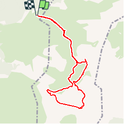
![](/images/other/stat-length.png)
![Trail Walking Arras-en-Lavedan - Pic du Cabaliros - Photo](https://media.geolcdn.com/t/1900/400/ext.pjpeg?maxdim=2&url=https%3A%2F%2Fservices.sitytrail.com%2FGeolivesWS%2FDownloadMedia.ashx%3FTrailID%3D108804%26Media%3D2125_4.jpg)
Pic du Cabaliros
tracegps
User
![Length](/images/other/stat-length.png)
![Max alt](https://static1.geolcdn.com/siteimages/upload/files/1508320355ic_sort_altitude_max_24dp.png)
![Uphill gradient](https://static1.geolcdn.com/siteimages/upload/files/1508320355ic_sort_den_pos_24dp.png)
![Km-Effort](/images/other/stat-length.png)
![Min alt](https://static1.geolcdn.com/siteimages/upload/files/1508320355ic_sort_altitude_min_24dp.png)
![Downhill gradient](https://static1.geolcdn.com/siteimages/upload/files/1508320355ic_sort_den_neg_24dp.png)
![Boucle](https://static1.geolcdn.com/siteimages/upload/files/16400158638029165_repeat_loop_refresh_sync_direction_icon.png)
![Walking](https://static1.geolcdn.com/sitytour/trail-icons/101.png)
4h25
Difficulty : Difficult
![Scan this QR Code to open this trail in the SityTrail application](https://capi.geolives.com/qq0zvz2zws4bq2lad0pu/sitytour/trails/108804/qr.png?size=200)
FREE GPS app for hiking
About
Trail Walking of 9.4 km to be discovered at Occitania, Hautespyrenees, Arras-en-Lavedan. This trail is proposed by tracegps.
Description
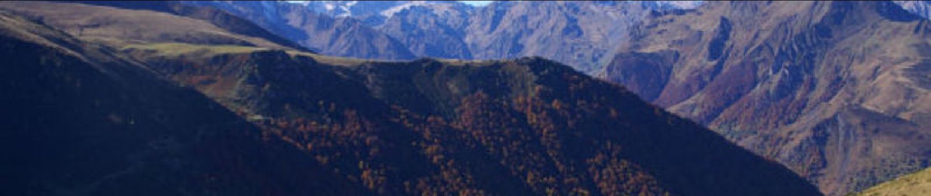
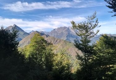
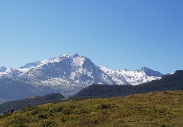
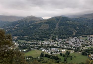
Le Pic du Cabaliros domine Argelès Gazost au nord et Cauterets au Sud, une petite virée sympatique s'impose! Pas de difficulté notoire mis à part les à pics dominants Cauterets qui peuvent impressionner les ames sensibles, mais elles peuvent détourner la tête! Une boucle en prime pour varier les plaisirs de l'oeil.
Positioning
Comments
Trails nearby
![Trail Walking Arcizans-Dessus - la fontaine de Nabias - Photo](https://media.geolcdn.com/t/375/260/7a92cfc2-a248-4e38-88ec-b8751d1d13fa.jpg&format=jpg&maxdim=2)
![Walking Walking](https://static1.geolcdn.com/sitytour/trail-icons/101.png)
Walking
![](/images/other/stat-length.png)
![](https://static1.geolcdn.com/siteimages/upload/files/16400158638029165_repeat_loop_refresh_sync_direction_icon.png)
![Trail Walking Estaing - Les Viellettes - Estaing - Photo](https://media.geolcdn.com/t/375/260/ext.jpg?maxdim=2&url=https%3A%2F%2Fservices.sitytrail.com%2FGeolivesWS%2FDownloadMedia.ashx%3FTrailID%3D101311%26Media%3D806_1.jpg)
![Walking Walking](https://static1.geolcdn.com/sitytour/trail-icons/101.png)
Walking
![](/images/other/stat-length.png)
![](https://static1.geolcdn.com/siteimages/upload/files/16400158638029165_repeat_loop_refresh_sync_direction_icon.png)
![Trail Walking Gaillagos - GAILLAGOS / Couret / Couraduque en boucle reco G3 - Photo](https://media.geolcdn.com/t/375/260/2bb3641c-adfa-48ae-af2a-1b58bf8f8276.jpg&format=jpg&maxdim=2)
![Walking Walking](https://static1.geolcdn.com/sitytour/trail-icons/101.png)
Walking
![](/images/other/stat-length.png)
![](https://static1.geolcdn.com/siteimages/upload/files/16400158638029165_repeat_loop_refresh_sync_direction_icon.png)
![Trail Walking Gaillagos - GAILLAGOS Col de Couret Couraduque en boucle G3 du 21/04/2023](https://media.geolcdn.com/t/375/260/a7a6faba-e7ef-4e8d-a26e-e7db5f8feac1.jpg&format=jpg&maxdim=2)
![Walking Walking](https://static1.geolcdn.com/sitytour/trail-icons/101.png)
Walking
![](/images/other/stat-length.png)
![](https://static1.geolcdn.com/siteimages/upload/files/16400158638029165_repeat_loop_refresh_sync_direction_icon.png)
![Trail Walking Arrens-Marsous - ARRENS-MARSOUS le chemin de la mine G4 3059377 - Photo](https://media.geolcdn.com/t/375/260/518ded4d-66a4-45f9-be9c-992637e83008.jpg&format=jpg&maxdim=2)
![Walking Walking](https://static1.geolcdn.com/sitytour/trail-icons/101.png)
Walking
![](/images/other/stat-length.png)
![](https://static1.geolcdn.com/siteimages/upload/files/16400158638029165_repeat_loop_refresh_sync_direction_icon.png)
![Trail Walking Arras-en-Lavedan - Sur la hauteur de Sireix - Photo](https://media.geolcdn.com/t/375/260/a335a4cf-7171-43e9-8ddc-25da1e58e82d.jpg&format=jpg&maxdim=2)
![Walking Walking](https://static1.geolcdn.com/sitytour/trail-icons/101.png)
Walking
![](/images/other/stat-length.png)
![](https://static1.geolcdn.com/siteimages/upload/files/16400158638029165_repeat_loop_refresh_sync_direction_icon.png)
![Trail Walking Saint-Savin - 3 chapelles fait - Photo](https://media.geolcdn.com/t/375/260/54fe7be2-2be4-4fbf-bdc7-ae8061797273.jpg&format=jpg&maxdim=2)
![Walking Walking](https://static1.geolcdn.com/sitytour/trail-icons/101.png)
Walking
![](/images/other/stat-length.png)
![](https://static1.geolcdn.com/siteimages/upload/files/16400158638029165_repeat_loop_refresh_sync_direction_icon.png)
![Trail Walking Arcizans-Dessus - boucle Arcizans-Dessus col de Couraduque Aucun Gaillagos - Photo](https://media.geolcdn.com/t/375/260/23567dad-82ce-4450-816b-70873c23a1d3.jpg&format=jpg&maxdim=2)
![Walking Walking](https://static1.geolcdn.com/sitytour/trail-icons/101.png)
Walking
![](/images/other/stat-length.png)
![](https://static1.geolcdn.com/siteimages/upload/files/16400158638029165_repeat_loop_refresh_sync_direction_icon.png)
![Trail Walking Saint-Savin - loudenvielle val louron ère partie - Photo](https://media.geolcdn.com/t/375/260/a2dc03af-6970-4489-a2ba-7b12a46fa91c.jpg&format=jpg&maxdim=2)
![Walking Walking](https://static1.geolcdn.com/sitytour/trail-icons/101.png)
Walking
![](/images/other/stat-length.png)
![](https://static1.geolcdn.com/siteimages/upload/files/16400158638029165_repeat_loop_refresh_sync_direction_icon.png)