![](/images/other/stat-length.png)
![Trail Walking Labaroche - La Roche du Corbeau - Photo](https://media.geolcdn.com/t/1900/400/ext.pjpeg?maxdim=2&url=https%3A%2F%2Fservices.sitytrail.com%2FGeolivesWS%2FDownloadMedia.ashx%3FTrailID%3D108800%26Media%3D2112_6.jpg)
La Roche du Corbeau
tracegps
User
![Length](/images/other/stat-length.png)
![Max alt](https://static1.geolcdn.com/siteimages/upload/files/1508320355ic_sort_altitude_max_24dp.png)
![Uphill gradient](https://static1.geolcdn.com/siteimages/upload/files/1508320355ic_sort_den_pos_24dp.png)
![Km-Effort](/images/other/stat-length.png)
![Min alt](https://static1.geolcdn.com/siteimages/upload/files/1508320355ic_sort_altitude_min_24dp.png)
![Downhill gradient](https://static1.geolcdn.com/siteimages/upload/files/1508320355ic_sort_den_neg_24dp.png)
![Boucle](https://static1.geolcdn.com/siteimages/upload/files/16400158638029165_repeat_loop_refresh_sync_direction_icon.png)
![Walking](https://static1.geolcdn.com/sitytour/trail-icons/101.png)
3h00
Difficulty : Medium
![Scan this QR Code to open this trail in the SityTrail application](https://capi.geolives.com/qq0zvz2zws4bq2lad0pu/sitytour/trails/108800/qr.png?size=200)
FREE GPS app for hiking
About
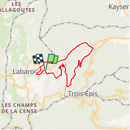
Trail Walking of 11.1 km to be discovered at Grand Est, Haut-Rhin, Labaroche. This trail is proposed by tracegps.
Description
Labaroche est un village de 2000 habitants, situé en Alsace à 20 km de Colmar. Accès par Ammerschwihr, par Turckheim ou Niedermorschwihr via Trois-Epis, ou par Orbey. D'une altitude moyenne de 750 mètres, la commune se trouve sur un plateau à cheval entre la vallée de Kaysersberg et celle de Munster. Les crêtes vosgiennes et la station de ski du Lac Blanc ne sont qu'à 20 km, mais vous trouverez des circuits de randonnées pédestres, à VTT, à cheval ou de ski de fond tout autour du village. Départ : Eglise du hameau de Basse Baroche.
Positioning
Comments
Trails nearby
![Trail Walking Ammerschwihr - Trois Épis le rocher du corbeau - Photo](https://media.geolcdn.com/t/375/260/dbdb5766-f574-4a80-9cd8-371c84f0061c.jpg&format=jpg&maxdim=2)
![Walking Walking](https://static1.geolcdn.com/sitytour/trail-icons/101.png)
Walking
![](/images/other/stat-length.png)
![](https://static1.geolcdn.com/siteimages/upload/files/16400158638029165_repeat_loop_refresh_sync_direction_icon.png)
![Trail Mountain bike Labaroche - Tour de Labaroche - Photo](https://media.geolcdn.com/t/375/260/ext.jpg?maxdim=2&url=https%3A%2F%2Fservices.sitytrail.com%2FGeolivesWS%2FDownloadMedia.ashx%3FTrailID%3D172875%26Media%3D14329_1.jpg)
![Mountain bike Mountain bike](https://static1.geolcdn.com/sitytour/trail-icons/202.png)
Mountain bike
![](/images/other/stat-length.png)
![](https://static1.geolcdn.com/siteimages/upload/files/16400158638029165_repeat_loop_refresh_sync_direction_icon.png)
![Trail Walking Lapoutroie - 2012-06-16 Marche aux Alisiers Orbey - Photo](https://media.geolcdn.com/t/375/260/ext.jpg?maxdim=2&url=https%3A%2F%2Fstatic1.geolcdn.com%2Fsiteimages%2Fupload%2Ffiles%2F1553511878bg_sport_marche.png)
![Walking Walking](https://static1.geolcdn.com/sitytour/trail-icons/101.png)
Walking
![](/images/other/stat-length.png)
![](https://static1.geolcdn.com/siteimages/upload/files/16400158638029165_repeat_loop_refresh_sync_direction_icon.png)
![Trail Walking Kaysersberg-Vignoble - Du ⛺️ aux 4 villages - Photo](https://media.geolcdn.com/t/375/260/47566d1f-1190-42ce-9084-8a92c1b5deab.jpg&format=jpg&maxdim=2)
![Walking Walking](https://static1.geolcdn.com/sitytour/trail-icons/101.png)
Walking
![](/images/other/stat-length.png)
![](https://static1.geolcdn.com/siteimages/upload/files/16400158638029165_repeat_loop_refresh_sync_direction_icon.png)
![Trail Horseback riding Gunsbach - Le petit Hohnack - verkort (23) - Photo](https://media.geolcdn.com/t/375/260/ext.jpg?maxdim=2&url=https%3A%2F%2Fstatic1.geolcdn.com%2Fsiteimages%2Fupload%2Ffiles%2F1524743154cheval.jpg)
![Horseback riding Horseback riding](https://static1.geolcdn.com/sitytour/trail-icons/301.png)
Horseback riding
![](/images/other/stat-length.png)
![](https://static1.geolcdn.com/siteimages/upload/files/16400158638029165_repeat_loop_refresh_sync_direction_icon.png)
![Trail Walking Wintzenheim - Boucle de la fontaine de la dame - Photo](https://media.geolcdn.com/t/375/260/ee79f3ee-48dc-4e78-8e39-2ea9fd8c2e7b.jpg&format=jpg&maxdim=2)
![Walking Walking](https://static1.geolcdn.com/sitytour/trail-icons/101.png)
Walking
![](/images/other/stat-length.png)
![](https://static1.geolcdn.com/siteimages/upload/files/16400158638029165_repeat_loop_refresh_sync_direction_icon.png)
![Trail Walking Kaysersberg-Vignoble - 2021-05-30 Marche Kaysersberg Ursprung St Alexis - Photo](https://media.geolcdn.com/t/375/260/4ae16611-5255-49df-be17-2a5aa0e78321.jpg&format=jpg&maxdim=2)
![Walking Walking](https://static1.geolcdn.com/sitytour/trail-icons/101.png)
Walking
![](/images/other/stat-length.png)
![](https://static1.geolcdn.com/siteimages/upload/files/16400158638029165_repeat_loop_refresh_sync_direction_icon.png)
![Trail Horseback riding Kaysersberg-Vignoble - 2019-10-26 CDTE67 Tournage Video Promotion TE - Photo](https://media.geolcdn.com/t/375/260/d78bcf89-6739-4bcc-854f-0c743f5412b8.jpg&format=jpg&maxdim=2)
![Horseback riding Horseback riding](https://static1.geolcdn.com/sitytour/trail-icons/301.png)
Horseback riding
![](/images/other/stat-length.png)
![](https://static1.geolcdn.com/siteimages/upload/files/16400158638029165_repeat_loop_refresh_sync_direction_icon.png)
![Trail Walking Orbey - Orbey-Labaroche - Photo](https://media.geolcdn.com/t/375/260/ext.jpg?maxdim=2&url=https%3A%2F%2Fstatic1.geolcdn.com%2Fsiteimages%2Fupload%2Ffiles%2F1553511878bg_sport_marche.png)
![Walking Walking](https://static1.geolcdn.com/sitytour/trail-icons/101.png)
Walking
![](/images/other/stat-length.png)
![](https://static1.geolcdn.com/siteimages/upload/files/16400158638029165_repeat_loop_refresh_sync_direction_icon.png)