![](/images/other/stat-length.png)
![Trail Walking Salins-les-Bains - Le Mont Poupet (850 m) - Photo](https://media.geolcdn.com/t/1900/400/ext.pjpeg?maxdim=2&url=https%3A%2F%2Fservices.sitytrail.com%2FGeolivesWS%2FDownloadMedia.ashx%3FTrailID%3D108774%26Media%3D1916_2.jpg)
Le Mont Poupet (850 m)
tracegps
User
![Length](/images/other/stat-length.png)
![Max alt](https://static1.geolcdn.com/siteimages/upload/files/1508320355ic_sort_altitude_max_24dp.png)
![Uphill gradient](https://static1.geolcdn.com/siteimages/upload/files/1508320355ic_sort_den_pos_24dp.png)
![Km-Effort](/images/other/stat-length.png)
![Min alt](https://static1.geolcdn.com/siteimages/upload/files/1508320355ic_sort_altitude_min_24dp.png)
![Downhill gradient](https://static1.geolcdn.com/siteimages/upload/files/1508320355ic_sort_den_neg_24dp.png)
![Boucle](https://static1.geolcdn.com/siteimages/upload/files/16400158638029165_repeat_loop_refresh_sync_direction_icon.png)
![Walking](https://static1.geolcdn.com/sitytour/trail-icons/101.png)
5h00
Difficulty : Difficult
![Scan this QR Code to open this trail in the SityTrail application](https://capi.geolives.com/qq0zvz2zws4bq2lad0pu/sitytour/trails/108774/qr.png?size=200)
FREE GPS app for hiking
About
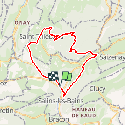
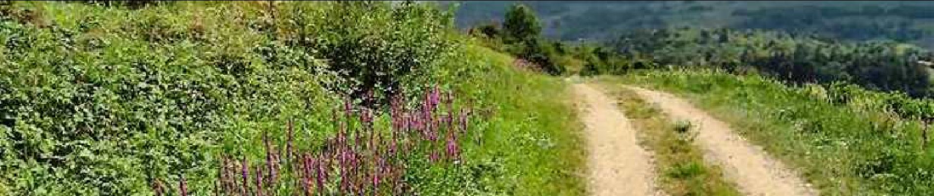
Trail Walking of 16.8 km to be discovered at Bourgogne-Franche-Comté, Jura, Salins-les-Bains. This trail is proposed by tracegps.
Description
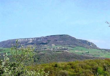
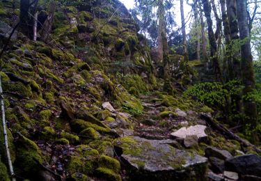
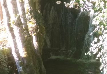
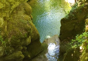
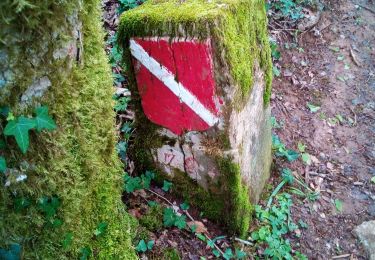
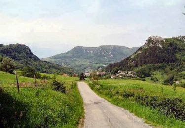
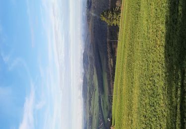
Avec ses 850 m d'altitude et ses pentes abruptes, le Mont Poupet est certainement l'un des plus beaux sommets de la bordure du Jura. Sa situation relativement isolée lui permet d'offrir une belle vue très dégagée qui porte des plaines du Doubs et de la Loue au nord-ouest à la plupart des sommets de la Haute-Chaîne du Jura et le Mont-Blanc au sud (à condition évidemment que le temps soit très clair). En contrebas, magnifique vue plongeante sur Salins-les-Bains, sa cluse et ses forts, la vallée de la Furieuse et de l'autre côté le premier plateau du Jura. A ne pas rater ! La suite avec d’autres informations et photos est ICI
Positioning
Comments
Trails nearby
![Trail Walking Pagnoz - Colline et ruines du château de Vaulgrenant - Photo](https://media.geolcdn.com/t/375/260/ext.jpg?maxdim=2&url=https%3A%2F%2Fservices.sitytrail.com%2FGeolivesWS%2FDownloadMedia.ashx%3FTrailID%3D108771%26Media%3D1913_1.jpg)
![Walking Walking](https://static1.geolcdn.com/sitytour/trail-icons/101.png)
Walking
![](/images/other/stat-length.png)
![](https://static1.geolcdn.com/siteimages/upload/files/16400158638029165_repeat_loop_refresh_sync_direction_icon.png)
![Trail Walking Saizenay - Saizenay_Mt Poupet - Photo](https://media.geolcdn.com/t/375/260/ext.jpg?maxdim=2&url=https%3A%2F%2Fservices.sitytrail.com%2FGeolivesWS%2FDownloadMedia.ashx%3FTrailID%3D243535%26Media%3D19f600c2-652e-47aa-bdd5-be6e172b09ab.jpg)
![Walking Walking](https://static1.geolcdn.com/sitytour/trail-icons/101.png)
Walking
![](/images/other/stat-length.png)
![](https://static1.geolcdn.com/siteimages/upload/files/16400158638029165_repeat_loop_refresh_sync_direction_icon.png)
![Trail Walking Ivrey - Nans sous ste Anne - Photo](https://media.geolcdn.com/t/375/260/2c1907f9-25f3-456f-93de-39df357245b8.jpg&format=jpg&maxdim=2)
![Walking Walking](https://static1.geolcdn.com/sitytour/trail-icons/101.png)
Walking
![](/images/other/stat-length.png)
![](https://static1.geolcdn.com/siteimages/upload/files/16400158638029165_repeat_loop_refresh_sync_direction_icon.png)
![Trail Walking Marnoz - Marnoz Fort St André Fort Belin Salin 8 sept 2020 CAF - Photo](https://media.geolcdn.com/t/375/260/cdb91fff-1d43-4f4c-9a00-4f9a0c26d660.jpg&format=jpg&maxdim=2)
![Walking Walking](https://static1.geolcdn.com/sitytour/trail-icons/101.png)
Walking
![](/images/other/stat-length.png)
![](https://static1.geolcdn.com/siteimages/upload/files/16400158638029165_repeat_loop_refresh_sync_direction_icon.png)
![Trail Walking Ivrey - Ivrey - Mr Poupet 7 juillet 20250 CAF - Photo](https://media.geolcdn.com/t/375/260/5f9423aa-ea9d-41da-ade4-234e9fd3c0f0.jpg&format=jpg&maxdim=2)
![Walking Walking](https://static1.geolcdn.com/sitytour/trail-icons/101.png)
Walking
![](/images/other/stat-length.png)
![](https://static1.geolcdn.com/siteimages/upload/files/16400158638029165_repeat_loop_refresh_sync_direction_icon.png)
![Trail On foot Salins-les-Bains - SALIN LES BAINS - GOUR DE CONCHE - Photo](https://media.geolcdn.com/t/375/260/c13f4862-e5b7-47a2-9786-eb7e32fcb419.jpg&format=jpg&maxdim=2)
![On foot On foot](https://static1.geolcdn.com/sitytour/trail-icons/100.png)
On foot
![](/images/other/stat-length.png)
![](https://static1.geolcdn.com/siteimages/upload/files/16400158638029165_repeat_loop_refresh_sync_direction_icon.png)
![Trail Walking Ivrey - Mont POUPET SALINS LES BAINS - Photo](https://media.geolcdn.com/t/375/260/86549112-5193-40f7-bfd7-a4668e312ffe.jpg&format=jpg&maxdim=2)
![Walking Walking](https://static1.geolcdn.com/sitytour/trail-icons/101.png)
Walking
![](/images/other/stat-length.png)
![](https://static1.geolcdn.com/siteimages/upload/files/16400158638029165_repeat_loop_refresh_sync_direction_icon.png)
![Trail Walking Salins-les-Bains - Tille de Bracon - Grange Sauvaget - Photo](https://media.geolcdn.com/t/375/260/ext.jpg?maxdim=2&url=https%3A%2F%2Fservices.sitytrail.com%2FGeolivesWS%2FDownloadMedia.ashx%3FTrailID%3D108773%26Media%3D1915_2.jpg)
![Walking Walking](https://static1.geolcdn.com/sitytour/trail-icons/101.png)
Walking
![](/images/other/stat-length.png)
![](https://static1.geolcdn.com/siteimages/upload/files/16400158638029165_repeat_loop_refresh_sync_direction_icon.png)
![Trail Walking Salins-les-Bains - Salins les bains Poupet 15.5 km - Photo](https://media.geolcdn.com/t/375/260/1e19e223-37d0-44b4-a647-ae6884de6f4b.jpg&format=jpg&maxdim=2)
![Walking Walking](https://static1.geolcdn.com/sitytour/trail-icons/101.png)
Walking
![](/images/other/stat-length.png)
![](https://static1.geolcdn.com/siteimages/upload/files/16400158638029165_repeat_loop_refresh_sync_direction_icon.png)
costaud
belle randonnée
top retour sous le soleil difficile