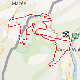
![](/images/other/stat-length.png)
![Trail Walking Vireux-Molhain - Circuit des Bornes Frontières - Photo](https://media.geolcdn.com/t/1900/400/ext.pjpeg?maxdim=2&url=https%3A%2F%2Fservices.sitytrail.com%2FGeolivesWS%2FDownloadMedia.ashx%3FTrailID%3D108717%26Media%3D1787_6.jpg)
Circuit des Bornes Frontières
tracegps
User
![Length](/images/other/stat-length.png)
![Max alt](https://static1.geolcdn.com/siteimages/upload/files/1508320355ic_sort_altitude_max_24dp.png)
![Uphill gradient](https://static1.geolcdn.com/siteimages/upload/files/1508320355ic_sort_den_pos_24dp.png)
![Km-Effort](/images/other/stat-length.png)
![Min alt](https://static1.geolcdn.com/siteimages/upload/files/1508320355ic_sort_altitude_min_24dp.png)
![Downhill gradient](https://static1.geolcdn.com/siteimages/upload/files/1508320355ic_sort_den_neg_24dp.png)
![Boucle](https://static1.geolcdn.com/siteimages/upload/files/16400158638029165_repeat_loop_refresh_sync_direction_icon.png)
![Walking](https://static1.geolcdn.com/sitytour/trail-icons/101.png)
3h30
Difficulty : Medium
![Scan this QR Code to open this trail in the SityTrail application](https://capi.geolives.com/qq0zvz2zws4bq2lad0pu/sitytour/trails/108717/qr.png?size=200)
FREE GPS app for hiking
About
Trail Walking of 12.5 km to be discovered at Grand Est, Ardennes, Vireux-Molhain. This trail is proposed by tracegps.
Description
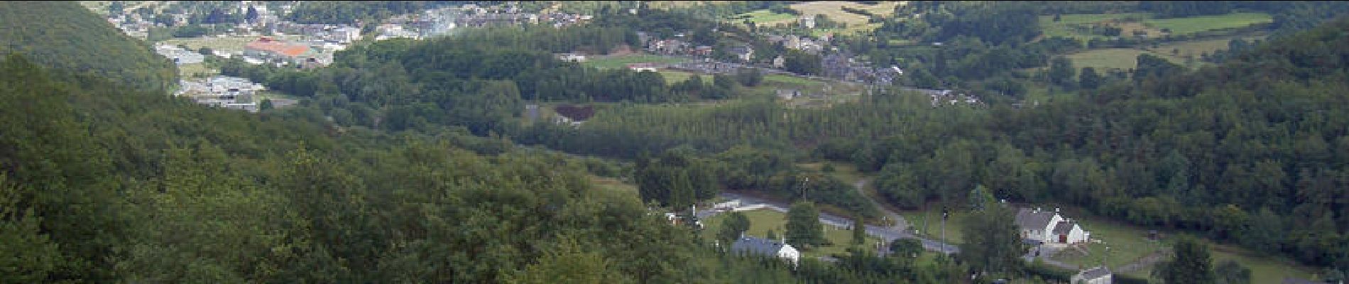
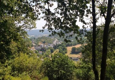
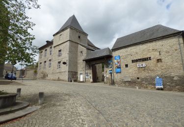
Par monts et vallées, la randonnée rencontre des points de vue exceptionnels sur la vallée du Viroin, la grande forêt des Ardennes Franco-Belges, la forêt de Thiérache et le site fortifié du Mont-Vireux. Les bornes frontières qui jalonnent les villages de Mazée, Najauge, Vireux-Mohain et Hierges délimitaient notamment la Principauté de Liège dont ces villages faisaient partie. Le traité des limites du 24 mai 1772, qui dépeça la Baronnie de Hierges, amena le passage en France de plusieurs entités comme Vireux, Revin, Fumay et Chooz. Ces 19 bornes qui étaient noircies et dépréciées par le temps ont été restaurées par une équipe de volontaires lors de l'année du petit patrimoine wallon et présentées aux visiteurs en 1991. Cette promenade transfrontalière aboutit au hameau de Mohain : au confluent de la Meuse et du Viroin, ce petit village, épris de qualité de vie, de culture et de patrimoine, vous fait découvrir ses paysages les plus secrets, notamment sa petite mais combien remarquable Collégiale fondée, comme le veut la tradition, en l'an 752, par Dame Ada sur le domaine offert à son mari, Wibert Comte de Poitier, par Pépin-le Bref, autour de laquelle se dressent les maisons des anciens chamoines. Elles étaient au centre d'une collectivité de religieux vivant selon une règle moins stricte que celle des monastères. La crypte est la partie la plus ancienne de l'édifice avec ses fines colonnes carolingiennes, dégagée pendant la première guerre mondiale par les Allemands qui recherchaient le tombeau de Pépin-le-Bref, donateur de Molhain. Départ : Office de tourisme du Viroquois. Balisage : losange bleu – losange jaune (contre sens) – losange bleu et GR 125.
Positioning
Comments
Trails nearby
![Trail Walking Viroinval - RB-Na-12 Ed4 Balade franco-belge chez Toine Culot - Photo](https://media.geolcdn.com/t/375/260/ext.jpg?maxdim=2&url=https%3A%2F%2Fservices.sitytrail.com%2FGeolivesWS%2FDownloadMedia.ashx%3FTrailID%3D794212%26Media%3D5fba0928-65b8-4f08-8244-3dd1e2295f4a.jpg)
![Walking Walking](https://static1.geolcdn.com/sitytour/trail-icons/101.png)
Walking
![](/images/other/stat-length.png)
![](https://static1.geolcdn.com/siteimages/upload/files/16400158638029165_repeat_loop_refresh_sync_direction_icon.png)
![Trail Walking Viroinval - Mazée, sur le sentier des Douaniers - Photo](https://media.geolcdn.com/t/375/260/e6a3fc86-55fd-4ddf-a6e6-df3228867288.jpg&format=jpg&maxdim=2)
![Walking Walking](https://static1.geolcdn.com/sitytour/trail-icons/101.png)
Walking
![](/images/other/stat-length.png)
![](https://static1.geolcdn.com/siteimages/upload/files/16400158638029165_repeat_loop_refresh_sync_direction_icon.png)
![Trail Walking Vireux-Molhain - Balade Franco-Belge - De Vireux-Molhain à Mazée - Photo](https://media.geolcdn.com/t/375/260/ext.jpg?maxdim=2&url=https%3A%2F%2Fservices.sitytrail.com%2FGeolivesWS%2FDownloadMedia.ashx%3FTrailID%3D191490%26Media%3D15083_5.jpg)
![Walking Walking](https://static1.geolcdn.com/sitytour/trail-icons/101.png)
Walking
![](/images/other/stat-length.png)
![](https://static1.geolcdn.com/siteimages/upload/files/16400158638029165_repeat_loop_refresh_sync_direction_icon.png)
![Trail Walking Vireux-Molhain - Du Mont Vireux au château de Hierges - Photo](https://media.geolcdn.com/t/375/260/ext.jpg?maxdim=2&url=https%3A%2F%2Fservices.sitytrail.com%2FGeolivesWS%2FDownloadMedia.ashx%3FTrailID%3D108904%26Media%3D2563_6.jpg)
![Walking Walking](https://static1.geolcdn.com/sitytour/trail-icons/101.png)
Walking
![](/images/other/stat-length.png)
![](https://static1.geolcdn.com/siteimages/upload/files/16400158638029165_repeat_loop_refresh_sync_direction_icon.png)
![Trail Walking Vireux-Molhain - Du Mont Vireux au château de Hierges - Photo](https://media.geolcdn.com/t/375/260/ext.jpg?maxdim=2&url=https%3A%2F%2Fstatic1.geolcdn.com%2Fsiteimages%2Fupload%2Ffiles%2F1553511878bg_sport_marche.png)
![Walking Walking](https://static1.geolcdn.com/sitytour/trail-icons/101.png)
Walking
![](/images/other/stat-length.png)
![](https://static1.geolcdn.com/siteimages/upload/files/16400158638029165_repeat_loop_refresh_sync_direction_icon.png)
![Walking Walking](https://static1.geolcdn.com/sitytour/trail-icons/101.png)
Walking
![](/images/other/stat-length.png)
![](https://static1.geolcdn.com/siteimages/upload/files/16400158638029165_repeat_loop_refresh_sync_direction_icon.png)
![Trail On foot Viroinval - La Villa Gallo-Romaine - Photo](https://media.geolcdn.com/t/375/260/0fbc23cb-6394-4025-9f50-97c9c9ed0621.jpeg&format=jpg&maxdim=2)
![On foot On foot](https://static1.geolcdn.com/sitytour/trail-icons/100.png)
On foot
![](/images/other/stat-length.png)
![](https://static1.geolcdn.com/siteimages/upload/files/16400158638029165_repeat_loop_refresh_sync_direction_icon.png)
![Trail On foot Viroinval - Pré Aigret - Photo](https://media.geolcdn.com/t/375/260/0fbc23cb-6394-4025-9f50-97c9c9ed0621.jpeg&format=jpg&maxdim=2)
![On foot On foot](https://static1.geolcdn.com/sitytour/trail-icons/100.png)
![Trail On foot Viroinval - Les Rivelottes - Photo](https://media.geolcdn.com/t/375/260/0fbc23cb-6394-4025-9f50-97c9c9ed0621.jpeg&format=jpg&maxdim=2)
![On foot On foot](https://static1.geolcdn.com/sitytour/trail-icons/100.png)
Chimay