![](/images/other/stat-length.png)
![Trail Mountain bike Pourrières - Pourrières - Sainte Victoire - Photo](https://media.geolcdn.com/t/1900/400/ext.pjpeg?maxdim=2&url=https%3A%2F%2Fservices.sitytrail.com%2FGeolivesWS%2FDownloadMedia.ashx%3FTrailID%3D108561%26Media%3D1469_1.jpg)
Pourrières - Sainte Victoire
tracegps
User
![Length](/images/other/stat-length.png)
Length
18.7 km
![Max alt](https://static1.geolcdn.com/siteimages/upload/files/1508320355ic_sort_altitude_max_24dp.png)
Max alt
557 m
![Uphill gradient](https://static1.geolcdn.com/siteimages/upload/files/1508320355ic_sort_den_pos_24dp.png)
Uphill gradient
407 m
![Km-Effort](/images/other/stat-length.png)
Km-Effort
24 km
![Min alt](https://static1.geolcdn.com/siteimages/upload/files/1508320355ic_sort_altitude_min_24dp.png)
Min alt
285 m
![Downhill gradient](https://static1.geolcdn.com/siteimages/upload/files/1508320355ic_sort_den_neg_24dp.png)
Downhill gradient
406 m
![Boucle](https://static1.geolcdn.com/siteimages/upload/files/16400158638029165_repeat_loop_refresh_sync_direction_icon.png)
Boucle
Yes
Creation date :
2014-12-10 00:00:00.0
Updated on :
2014-12-10 00:00:00.0
![Mountain bike](https://static1.geolcdn.com/sitytour/trail-icons/202.png)
2h00
Difficulty : Difficult
![Scan this QR Code to open this trail in the SityTrail application](https://capi.geolives.com/qq0zvz2zws4bq2lad0pu/sitytour/trails/108561/qr.png?size=200)
FREE GPS app for hiking
About
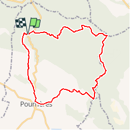
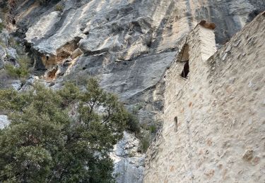
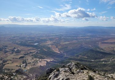
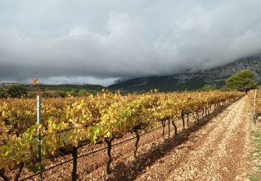
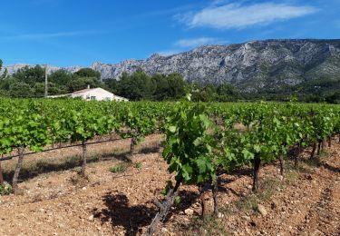
Trail Mountain bike of 18.7 km to be discovered at Provence-Alpes-Côte d'Azur, Var, Pourrières. This trail is proposed by tracegps.
Description
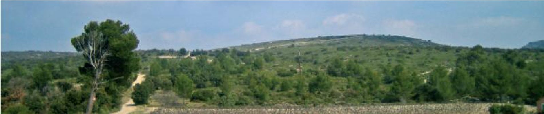
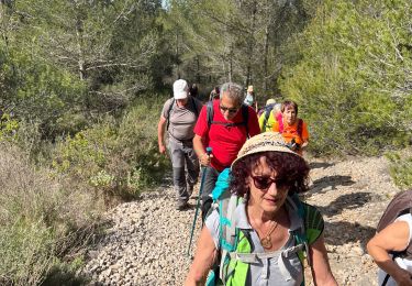
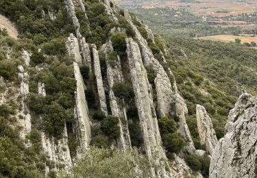
Une randonnée assez longue mais agréable, avec de belles vues sur le Mont Aurélien et la Sainte-Victoire. Le dénivelé reste modeste mais les pentes sont souvent raides. Un bon niveau physique est donc nécessaire. Retrouvez plus de précisions sur le site de VTOPO.com
Positioning
Country:
France
Region :
Provence-Alpes-Côte d'Azur
Department/Province :
Var
Municipality :
Pourrières
Location:
Unknown
Start:(Dec)
Start:(UTM)
720480 ; 4824155 (31T) N.
Comments
Trails nearby
![Trail Walking Puyloubier - 2023-02-03 Sainte Victoire - Le Pic des Mouches - Photo](https://media.geolcdn.com/t/375/260/485b71fb-d444-48f0-93df-e93d563947c5.jpg&format=jpg&maxdim=2)
![Walking Walking](https://static1.geolcdn.com/sitytour/trail-icons/101.png)
2023-02-03 Sainte Victoire - Le Pic des Mouches
Walking
Difficult
Puyloubier,
Provence-Alpes-Côte d'Azur,
Bouches-du-Rhône,
France
![](/images/other/stat-length.png)
10 km | 19 km-effort
3h 10min
![](https://static1.geolcdn.com/siteimages/upload/files/16400158638029165_repeat_loop_refresh_sync_direction_icon.png)
Yes
![On foot On foot](https://static1.geolcdn.com/sitytour/trail-icons/100.png)
Garagaï de Cagoloup- Ste Victoire-11-12-24
On foot
Medium
Puyloubier,
Provence-Alpes-Côte d'Azur,
Bouches-du-Rhône,
France
![](/images/other/stat-length.png)
17.7 km | 27 km-effort
6h 12min
![](https://static1.geolcdn.com/siteimages/upload/files/16400158638029165_repeat_loop_refresh_sync_direction_icon.png)
Yes
![Trail Walking Puyloubier - Puyloubier : St Ser-col des Portes - Photo](https://media.geolcdn.com/t/375/260/0b56fcca-8759-4413-9017-b9e823aea0a6.jpg&format=jpg&maxdim=2)
![Walking Walking](https://static1.geolcdn.com/sitytour/trail-icons/101.png)
Puyloubier : St Ser-col des Portes
Walking
Difficult
Puyloubier,
Provence-Alpes-Côte d'Azur,
Bouches-du-Rhône,
France
![](/images/other/stat-length.png)
21 km | 34 km-effort
7h 42min
![](https://static1.geolcdn.com/siteimages/upload/files/16400158638029165_repeat_loop_refresh_sync_direction_icon.png)
Yes
![Trail Walking Pourrières - Puyloubier - Photo](https://media.geolcdn.com/t/375/260/26e51f64-e9dc-4715-9c05-119db4965cd2.jpg&format=jpg&maxdim=2)
![Walking Walking](https://static1.geolcdn.com/sitytour/trail-icons/101.png)
Puyloubier
Walking
Medium
Pourrières,
Provence-Alpes-Côte d'Azur,
Var,
France
![](/images/other/stat-length.png)
12.3 km | 17.3 km-effort
5h 49min
![](https://static1.geolcdn.com/siteimages/upload/files/16400158638029165_repeat_loop_refresh_sync_direction_icon.png)
Yes
![Trail Walking Puyloubier - Ste Victoire (pic des Mouches et brèche du clapier) - Photo](https://media.geolcdn.com/t/375/260/e67a64f9-9bee-4612-94ef-092747dbfc1f.jpg&format=jpg&maxdim=2)
![Walking Walking](https://static1.geolcdn.com/sitytour/trail-icons/101.png)
Ste Victoire (pic des Mouches et brèche du clapier)
Walking
Very difficult
Puyloubier,
Provence-Alpes-Côte d'Azur,
Bouches-du-Rhône,
France
![](/images/other/stat-length.png)
18.4 km | 33 km-effort
5h 32min
![](https://static1.geolcdn.com/siteimages/upload/files/16400158638029165_repeat_loop_refresh_sync_direction_icon.png)
Yes
![Trail Walking Puyloubier - Ste victoire - Photo](https://media.geolcdn.com/t/375/260/95104e59-c038-453c-9aa6-a274c8f1a5d4.jpg&format=jpg&maxdim=2)
![Walking Walking](https://static1.geolcdn.com/sitytour/trail-icons/101.png)
Ste victoire
Walking
Very difficult
Puyloubier,
Provence-Alpes-Côte d'Azur,
Bouches-du-Rhône,
France
![](/images/other/stat-length.png)
18.5 km | 33 km-effort
5h 29min
![](https://static1.geolcdn.com/siteimages/upload/files/16400158638029165_repeat_loop_refresh_sync_direction_icon.png)
Yes
![Trail Walking Vauvenargues - le pic des mouches et la citadelle - Photo](https://media.geolcdn.com/t/375/260/f0b99cdd-4c42-42cb-9f56-41c06ea31beb.jpg&format=jpg&maxdim=2)
![Walking Walking](https://static1.geolcdn.com/sitytour/trail-icons/101.png)
le pic des mouches et la citadelle
Walking
Easy
Vauvenargues,
Provence-Alpes-Côte d'Azur,
Bouches-du-Rhône,
France
![](/images/other/stat-length.png)
11.4 km | 18.3 km-effort
3h 53min
![](https://static1.geolcdn.com/siteimages/upload/files/16400158638029165_repeat_loop_refresh_sync_direction_icon.png)
Yes
![Trail Walking Puyloubier - La Ste Victoire-Citadelle-03-11-21 - Photo](https://media.geolcdn.com/t/375/260/3d431f8c-0991-4a71-bdbe-31d86a0542ea.jpg&format=jpg&maxdim=2)
![Walking Walking](https://static1.geolcdn.com/sitytour/trail-icons/101.png)
La Ste Victoire-Citadelle-03-11-21
Walking
Difficult
Puyloubier,
Provence-Alpes-Côte d'Azur,
Bouches-du-Rhône,
France
![](/images/other/stat-length.png)
15.3 km | 27 km-effort
6h 16min
![](https://static1.geolcdn.com/siteimages/upload/files/16400158638029165_repeat_loop_refresh_sync_direction_icon.png)
Yes
![Trail Walking Puyloubier - Ste Victoire sud-03-06-21 - Photo](https://media.geolcdn.com/t/375/260/a1392a31-85af-43f4-a3ca-a08ef223bb01.jpg&format=jpg&maxdim=2)
![Walking Walking](https://static1.geolcdn.com/sitytour/trail-icons/101.png)
Ste Victoire sud-03-06-21
Walking
Medium
Puyloubier,
Provence-Alpes-Côte d'Azur,
Bouches-du-Rhône,
France
![](/images/other/stat-length.png)
18.6 km | 29 km-effort
5h 36min
![](https://static1.geolcdn.com/siteimages/upload/files/16400158638029165_repeat_loop_refresh_sync_direction_icon.png)
Yes