![](/images/other/stat-length.png)
![Trail Walking Chauvac-Laux-Montaux - Tour des Baronnies du Buëch - Chauvac - Laborel - Photo](https://media.geolcdn.com/t/1900/400/ext.pjpeg?maxdim=2&url=https%3A%2F%2Fservices.sitytrail.com%2FGeolivesWS%2FDownloadMedia.ashx%3FTrailID%3D108459%26Media%3D1171_1.jpg)
Tour des Baronnies du Buëch - Chauvac - Laborel
tracegps
User
![Length](/images/other/stat-length.png)
![Max alt](https://static1.geolcdn.com/siteimages/upload/files/1508320355ic_sort_altitude_max_24dp.png)
![Uphill gradient](https://static1.geolcdn.com/siteimages/upload/files/1508320355ic_sort_den_pos_24dp.png)
![Km-Effort](/images/other/stat-length.png)
![Min alt](https://static1.geolcdn.com/siteimages/upload/files/1508320355ic_sort_altitude_min_24dp.png)
![Downhill gradient](https://static1.geolcdn.com/siteimages/upload/files/1508320355ic_sort_den_neg_24dp.png)
![Boucle](https://static1.geolcdn.com/siteimages/upload/files/16400158638029165_repeat_loop_refresh_sync_direction_icon.png)
![Walking](https://static1.geolcdn.com/sitytour/trail-icons/101.png)
4h00
Difficulty : Difficult
![Scan this QR Code to open this trail in the SityTrail application](https://capi.geolives.com/qq0zvz2zws4bq2lad0pu/sitytour/trails/108459/qr.png?size=200)
FREE GPS app for hiking
About
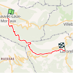
Trail Walking of 9.4 km to be discovered at Auvergne-Rhône-Alpes, Drôme, Chauvac-Laux-Montaux. This trail is proposed by tracegps.
Description
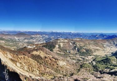
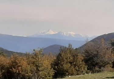
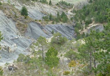
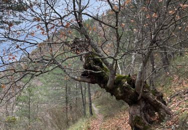
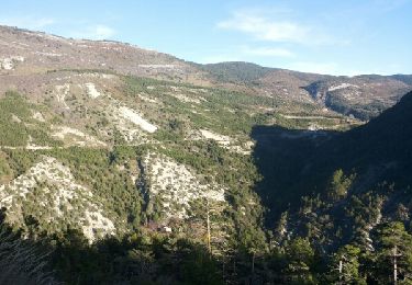
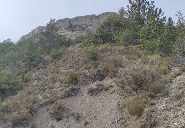
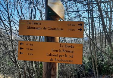
Le tout nouveau Tour des Baronnies du Buëch est un projet initié par la communauté des communes interdépartementale des Baronnies. « Colonne vertébrale » de la petite randonnée dans le Buëch, il constitue un produit d’appel pour la randonnée sur notre territoire. Cette itinéraire en crête offre des paysages somptueux tout en gardant une vue sur l’itinéraire réalisé et à parcourir. La 5ème étape du Tour des Baronnies du Buëch se caractérise par un parcours frais et ombragé ainsi que des passages en balcon fabuleux. Il n'y a pas de difficulté technique majeure, pas de passage vertigineux de pierriers mais cette étape est une des plus longue en distance et donc physiquement peut être une des plus contraignante.. Notons également la traversée de nombreux cols, la découverte de ruines.... Le rythme est ensuite plus saccadé avec des enchaînements de descentes et de montées avant d'arriver sous le col de Perty. La descente se fera ensuite sur un sentier en crête jusque Laborel. D’autres informations, carte et road-book sont disponibles ICI
Positioning
Comments
Trails nearby
![Trail Walking Laborel - Montagne de Chamouse - Photo](https://media.geolcdn.com/t/375/260/6ca43a5e-7183-48f1-b61e-fd0f610bad24.jpg&format=jpg&maxdim=2)
![Walking Walking](https://static1.geolcdn.com/sitytour/trail-icons/101.png)
Walking
![](/images/other/stat-length.png)
![](https://static1.geolcdn.com/siteimages/upload/files/16400158638029165_repeat_loop_refresh_sync_direction_icon.png)
![Trail Walking Montauban-sur-l'Ouvèze - LABOREL 26 , COL DE PERTY. MONTAGNE DE CHAMOUSE O m s - Photo](https://media.geolcdn.com/t/375/260/71ed4cbe-2cb1-4563-8183-7a9f39949568.jpg&format=jpg&maxdim=2)
![Walking Walking](https://static1.geolcdn.com/sitytour/trail-icons/101.png)
Walking
![](/images/other/stat-length.png)
![](https://static1.geolcdn.com/siteimages/upload/files/16400158638029165_repeat_loop_refresh_sync_direction_icon.png)
![Trail Walking Laborel - Crête de Chamouse - Laborel - Photo](https://media.geolcdn.com/t/375/260/ext.jpg?maxdim=2&url=https%3A%2F%2Fservices.sitytrail.com%2FGeolivesWS%2FDownloadMedia.ashx%3FTrailID%3D173182%26Media%3D14764_6.jpg)
![Walking Walking](https://static1.geolcdn.com/sitytour/trail-icons/101.png)
Walking
![](/images/other/stat-length.png)
![](https://static1.geolcdn.com/siteimages/upload/files/16400158638029165_repeat_loop_refresh_sync_direction_icon.png)
![Trail Walking Sorbiers - Balade chapelle st-honora - Photo](https://media.geolcdn.com/t/375/260/ba464381-1b59-4019-abcf-3c806b0e5614.jpg&format=jpg&maxdim=2)
![Walking Walking](https://static1.geolcdn.com/sitytour/trail-icons/101.png)
Walking
![](/images/other/stat-length.png)
![](https://static1.geolcdn.com/siteimages/upload/files/16400158638029165_repeat_loop_refresh_sync_direction_icon.png)
![Trail Walking Montauban-sur-l'Ouvèze - les abricotiers D65 - Photo](https://media.geolcdn.com/t/375/260/ext.jpg?maxdim=2&url=https%3A%2F%2Fservices.sitytrail.com%2FGeolivesWS%2FDownloadMedia.ashx%3FTrailID%3D501999%26Media%3Dfix__20151211152245.jpg)
![Walking Walking](https://static1.geolcdn.com/sitytour/trail-icons/101.png)
Walking
![](/images/other/stat-length.png)
![](https://static1.geolcdn.com/siteimages/upload/files/16400158638029165_repeat_loop_refresh_sync_direction_icon.png)
![Trail Walking Laborel - Laborel montagne de Chamouse - Photo](https://media.geolcdn.com/t/375/260/49aa88db-f4ad-449b-a998-960c028be1b1.jpg&format=jpg&maxdim=2)
![Walking Walking](https://static1.geolcdn.com/sitytour/trail-icons/101.png)
Walking
![](/images/other/stat-length.png)
![](https://static1.geolcdn.com/siteimages/upload/files/16400158638029165_repeat_loop_refresh_sync_direction_icon.png)
![Trail Walking Laborel - cretes de chamousse - Photo](https://media.geolcdn.com/t/375/260/17e90456-f4c5-4405-b38f-941907f5e8ed.jpg&format=jpg&maxdim=2)
![Walking Walking](https://static1.geolcdn.com/sitytour/trail-icons/101.png)
Walking
![](/images/other/stat-length.png)
![](https://static1.geolcdn.com/siteimages/upload/files/16400158638029165_repeat_loop_refresh_sync_direction_icon.png)
![Trail Walking Montauban-sur-l'Ouvèze - SityTrail - CHAMOUSE L'HIVER - Photo](https://media.geolcdn.com/t/375/260/ext.jpg?maxdim=2&url=https%3A%2F%2Fstatic1.geolcdn.com%2Fsiteimages%2Fupload%2Ffiles%2F1553511878bg_sport_marche.png)
![Walking Walking](https://static1.geolcdn.com/sitytour/trail-icons/101.png)
Walking
![](/images/other/stat-length.png)
![](https://static1.geolcdn.com/siteimages/upload/files/16400158638029165_repeat_loop_refresh_sync_direction_icon.png)
![Trail On foot Montauban-sur-l'Ouvèze - CHAMOUSE L'HIVER - Photo](https://media.geolcdn.com/t/375/260/ext.jpg?maxdim=2&url=https%3A%2F%2Fstatic1.geolcdn.com%2Fsiteimages%2Fupload%2Ffiles%2F1545311037marcheuse_200dpi.jpg)
![On foot On foot](https://static1.geolcdn.com/sitytour/trail-icons/100.png)
On foot
![](/images/other/stat-length.png)
![](https://static1.geolcdn.com/siteimages/upload/files/16400158638029165_repeat_loop_refresh_sync_direction_icon.png)