![](/images/other/stat-length.png)
![Trail Walking Montferrand-la-Fare - Tour des Baronnies du Buëch - Les Viarrands - Chauvac - Photo](https://media.geolcdn.com/t/1900/400/ext.pjpeg?maxdim=2&url=https%3A%2F%2Fservices.sitytrail.com%2FGeolivesWS%2FDownloadMedia.ashx%3FTrailID%3D108458%26Media%3D1170_1.jpg)
Tour des Baronnies du Buëch - Les Viarrands - Chauvac
tracegps
User
![Length](/images/other/stat-length.png)
![Max alt](https://static1.geolcdn.com/siteimages/upload/files/1508320355ic_sort_altitude_max_24dp.png)
![Uphill gradient](https://static1.geolcdn.com/siteimages/upload/files/1508320355ic_sort_den_pos_24dp.png)
![Km-Effort](/images/other/stat-length.png)
![Min alt](https://static1.geolcdn.com/siteimages/upload/files/1508320355ic_sort_altitude_min_24dp.png)
![Downhill gradient](https://static1.geolcdn.com/siteimages/upload/files/1508320355ic_sort_den_neg_24dp.png)
![Boucle](https://static1.geolcdn.com/siteimages/upload/files/16400158638029165_repeat_loop_refresh_sync_direction_icon.png)
![Walking](https://static1.geolcdn.com/sitytour/trail-icons/101.png)
4h00
Difficulty : Difficult
![Scan this QR Code to open this trail in the SityTrail application](https://capi.geolives.com/qq0zvz2zws4bq2lad0pu/sitytour/trails/108458/qr.png?size=200)
FREE GPS app for hiking
About
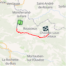
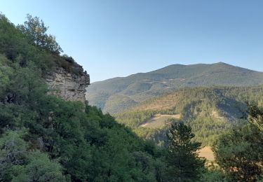
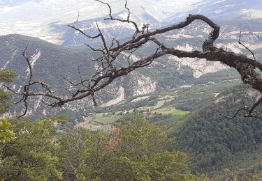
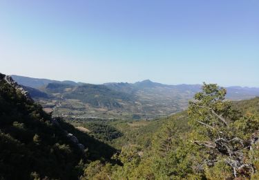
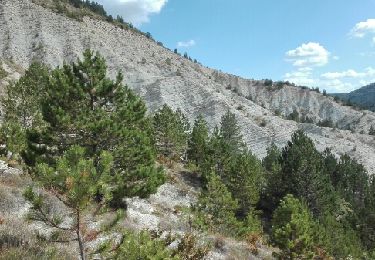
Trail Walking of 9.3 km to be discovered at Auvergne-Rhône-Alpes, Drôme, Montferrand-la-Fare. This trail is proposed by tracegps.
Description
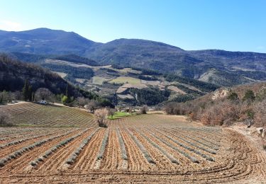
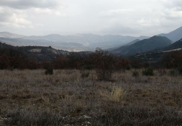
Le tout nouveau Tour des Baronnies du Buëch est un projet initié par la communauté des communes interdépartementale des Baronnies. « Colonne vertébrale » de la petite randonnée dans le Buëch, il constitue un produit d’appel pour la randonnée sur notre territoire. Cette itinéraire en crête offre des paysages somptueux tout en gardant une vue sur l’itinéraire réalisé et à parcourir. D’autres informations, carte et road-book sont disponibles ICI
Positioning
Comments
Trails nearby
![Trail Walking Sainte-Euphémie-sur-Ouvèze - 2024-04-21_15h22m31_26 Buis Petites-gorges-Ouvèze - Photo](https://media.geolcdn.com/t/375/260/50a924fc-c264-4be9-b1ba-9f2ef1fb0486.jpg&format=jpg&maxdim=2)
![Walking Walking](https://static1.geolcdn.com/sitytour/trail-icons/101.png)
Walking
![](/images/other/stat-length.png)
![](https://static1.geolcdn.com/siteimages/upload/files/16400158638029165_repeat_loop_refresh_sync_direction_icon.png)
![Trail Walking Sainte-Euphémie-sur-Ouvèze - Ste Euphémie- sur - Ouvéze 16 km. - Photo](https://media.geolcdn.com/t/375/260/01bea523-f1d0-4b3c-9ab3-81b6eb4ca226.jpg&format=jpg&maxdim=2)
![Walking Walking](https://static1.geolcdn.com/sitytour/trail-icons/101.png)
Walking
![](/images/other/stat-length.png)
![](https://static1.geolcdn.com/siteimages/upload/files/16400158638029165_repeat_loop_refresh_sync_direction_icon.png)
![Trail Walking Sainte-Euphémie-sur-Ouvèze - Ste Euphémie sur Ouvèze 15km - Photo](https://media.geolcdn.com/t/375/260/01620b9d-d313-4510-93cc-66e82aefda56.jpg&format=jpg&maxdim=2)
![Walking Walking](https://static1.geolcdn.com/sitytour/trail-icons/101.png)
Walking
![](/images/other/stat-length.png)
![](https://static1.geolcdn.com/siteimages/upload/files/16400158638029165_repeat_loop_refresh_sync_direction_icon.png)
![Trail Walking Sainte-Euphémie-sur-Ouvèze - Saint Euphemie sur ouveze - Photo](https://media.geolcdn.com/t/375/260/25b11b4e-538d-45f2-9913-81968b858953.jpg&format=jpg&maxdim=2)
![Walking Walking](https://static1.geolcdn.com/sitytour/trail-icons/101.png)
Walking
![](/images/other/stat-length.png)
![](https://static1.geolcdn.com/siteimages/upload/files/16400158638029165_repeat_loop_refresh_sync_direction_icon.png)
![Trail Walking Sainte-Euphémie-sur-Ouvèze - Repérage Ste Euphemie - Photo](https://media.geolcdn.com/t/375/260/8283064c-18c6-4123-a547-115725695c1e.jpg&format=jpg&maxdim=2)
![Walking Walking](https://static1.geolcdn.com/sitytour/trail-icons/101.png)
Walking
![](/images/other/stat-length.png)
![](https://static1.geolcdn.com/siteimages/upload/files/16400158638029165_repeat_loop_refresh_sync_direction_icon.png)
![Trail Walking Montferrand-la-Fare - le col viaran - Photo](https://media.geolcdn.com/t/375/260/d3f2803c-61b9-4e3b-9007-722f3d73e4f5.jpg&format=jpg&maxdim=2)
![Walking Walking](https://static1.geolcdn.com/sitytour/trail-icons/101.png)
Walking
![](/images/other/stat-length.png)
![](https://static1.geolcdn.com/siteimages/upload/files/16400158638029165_repeat_loop_refresh_sync_direction_icon.png)
![Trail Walking Saint-Sauveur-Gouvernet - La Bâtie Verdun-La Vanige 10km - Photo](https://media.geolcdn.com/t/375/260/d1982dba-00f0-44c6-92cc-49d252f589fb.jpg&format=jpg&maxdim=2)
![Walking Walking](https://static1.geolcdn.com/sitytour/trail-icons/101.png)
Walking
![](/images/other/stat-length.png)
![](https://static1.geolcdn.com/siteimages/upload/files/16400158638029165_repeat_loop_refresh_sync_direction_icon.png)
![Trail Other activity Montferrand-la-Fare - 26 09 Chèvre verte Vergol - Photo](https://media.geolcdn.com/t/375/260/ext.jpg?maxdim=2&url=https%3A%2F%2Fservices.sitytrail.com%2FGeolivesWS%2FDownloadMedia.ashx%3FTrailID%3D637438%26Media%3Dfix__20160926144918.jpg)
![Other activity Other activity](https://static1.geolcdn.com/sitytour/trail-icons/900.png)
Other activity
![](/images/other/stat-length.png)
![](https://static1.geolcdn.com/siteimages/upload/files/16400158638029165_repeat_loop_refresh_sync_direction_icon.png)
![Trail Other activity Montferrand-la-Fare - 26 09 Chèvre verte Vergol - Photo](https://media.geolcdn.com/t/375/260/ext.jpg?maxdim=2&url=https%3A%2F%2Fservices.sitytrail.com%2FGeolivesWS%2FDownloadMedia.ashx%3FTrailID%3D636876%26Media%3Dfix__20160926144918.jpg)
![Other activity Other activity](https://static1.geolcdn.com/sitytour/trail-icons/900.png)
Other activity
![](/images/other/stat-length.png)
![](https://static1.geolcdn.com/siteimages/upload/files/16400158638029165_repeat_loop_refresh_sync_direction_icon.png)