![](/images/other/stat-length.png)
![Trail Walking Mont-Saint-Père - Le coteau des orchidées - variante - Photo](https://media.geolcdn.com/t/1900/400/ext.pjpeg?maxdim=2&url=https%3A%2F%2Fstatic1.geolcdn.com%2Fsiteimages%2Fupload%2Ffiles%2F1553511878bg_sport_marche.png)
Le coteau des orchidées - variante
tracegps
User
![Length](/images/other/stat-length.png)
Length
6.6 km
![Max alt](https://static1.geolcdn.com/siteimages/upload/files/1508320355ic_sort_altitude_max_24dp.png)
Max alt
166 m
![Uphill gradient](https://static1.geolcdn.com/siteimages/upload/files/1508320355ic_sort_den_pos_24dp.png)
Uphill gradient
169 m
![Km-Effort](/images/other/stat-length.png)
Km-Effort
8.9 km
![Min alt](https://static1.geolcdn.com/siteimages/upload/files/1508320355ic_sort_altitude_min_24dp.png)
Min alt
59 m
![Downhill gradient](https://static1.geolcdn.com/siteimages/upload/files/1508320355ic_sort_den_neg_24dp.png)
Downhill gradient
169 m
![Boucle](https://static1.geolcdn.com/siteimages/upload/files/16400158638029165_repeat_loop_refresh_sync_direction_icon.png)
Boucle
Yes
Creation date :
2014-12-10 00:00:00.0
Updated on :
2014-12-10 00:00:00.0
![Walking](https://static1.geolcdn.com/sitytour/trail-icons/101.png)
1h45
Difficulty : Medium
![Scan this QR Code to open this trail in the SityTrail application](https://capi.geolives.com/qq0zvz2zws4bq2lad0pu/sitytour/trails/108445/qr.png?size=200)
FREE GPS app for hiking
About
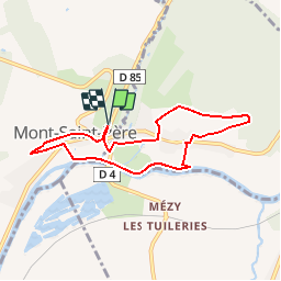
Trail Walking of 6.6 km to be discovered at Hauts-de-France, Aisne, Mont-Saint-Père. This trail is proposed by tracegps.
Description
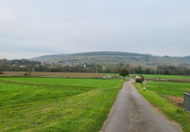
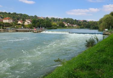
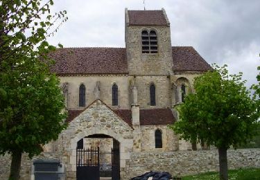
Le coteau de Chartèves, le village perché de Mont-Saint-Père, l'église gothique de Mézy-Moulins à proximité et la table d'orientation de Gland sont les temps forts de cette grande boucle qui s'étire le long de la Marne. Toutes les infos sont ICI
Positioning
Country:
France
Region :
Hauts-de-France
Department/Province :
Aisne
Municipality :
Mont-Saint-Père
Location:
Unknown
Start:(Dec)
Start:(UTM)
536203 ; 5436092 (31U) N.
Comments
Trails nearby
![Trail Walking Mont-Saint-Père - Le coteau des orchidées - Photo](https://media.geolcdn.com/t/375/260/ext.jpg?maxdim=2&url=https%3A%2F%2Fservices.sitytrail.com%2FGeolivesWS%2FDownloadMedia.ashx%3FTrailID%3D108165%26Media%3D565_1.jpg)
![Walking Walking](https://static1.geolcdn.com/sitytour/trail-icons/101.png)
Le coteau des orchidées
Walking
Difficult
(1)
Mont-Saint-Père,
Hauts-de-France,
Aisne,
France
![](/images/other/stat-length.png)
14.1 km | 18.1 km-effort
4h 0min
![](https://static1.geolcdn.com/siteimages/upload/files/16400158638029165_repeat_loop_refresh_sync_direction_icon.png)
Yes
![Trail Walking Jaulgonne - GR15 de Jaulgonne à Château du 29/01/2025 - Photo](https://media.geolcdn.com/t/375/260/da85ecf8-5aa6-4eea-a458-ccaed6b8a68d.jpg&format=jpg&maxdim=2)
![Walking Walking](https://static1.geolcdn.com/sitytour/trail-icons/101.png)
GR15 de Jaulgonne à Château du 29/01/2025
Walking
Difficult
Jaulgonne,
Hauts-de-France,
Aisne,
France
![](/images/other/stat-length.png)
14.7 km | 17.4 km-effort
3h 56min
![](https://static1.geolcdn.com/siteimages/upload/files/16400158638029165_repeat_loop_refresh_sync_direction_icon.png)
No
![Trail Walking Mont-Saint-Père - Mont st Père - Bonneil par le GR15 du 16-04-2024 - Photo](https://media.geolcdn.com/t/375/260/105504aa-0c76-40c2-8c92-e2efde603871.jpg&format=jpg&maxdim=2)
![Walking Walking](https://static1.geolcdn.com/sitytour/trail-icons/101.png)
Mont st Père - Bonneil par le GR15 du 16-04-2024
Walking
Very difficult
Mont-Saint-Père,
Hauts-de-France,
Aisne,
France
![](/images/other/stat-length.png)
20 km | 26 km-effort
5h 51min
![](https://static1.geolcdn.com/siteimages/upload/files/16400158638029165_repeat_loop_refresh_sync_direction_icon.png)
No
![Walking Walking](https://static1.geolcdn.com/sitytour/trail-icons/101.png)
Randonnée Blesmoise du 12 Mai 2019
Walking
Very easy
Blesmes,
Hauts-de-France,
Aisne,
France
![](/images/other/stat-length.png)
10.5 km | 13.8 km-effort
2h 59min
![](https://static1.geolcdn.com/siteimages/upload/files/16400158638029165_repeat_loop_refresh_sync_direction_icon.png)
Yes
![Trail Walking Mézy-Moulins - La rose sur la Marne - Photo](https://media.geolcdn.com/t/375/260/ext.jpg?maxdim=2&url=https%3A%2F%2Fservices.sitytrail.com%2FGeolivesWS%2FDownloadMedia.ashx%3FTrailID%3D202825%26Media%3Dc61eb99f-ad58-4cc0-bbd2-e88dc7ec2188.jpg)
![Walking Walking](https://static1.geolcdn.com/sitytour/trail-icons/101.png)
La rose sur la Marne
Walking
Very easy
Mézy-Moulins,
Hauts-de-France,
Aisne,
France
![](/images/other/stat-length.png)
7.1 km | 9 km-effort
Unknown
![](https://static1.geolcdn.com/siteimages/upload/files/16400158638029165_repeat_loop_refresh_sync_direction_icon.png)
Yes
![Trail Mountain bike Mont-Saint-Père - Vallée du Surmelin - Mont Saint Père - Photo](https://media.geolcdn.com/t/375/260/ext.jpg?maxdim=2&url=https%3A%2F%2Fservices.sitytrail.com%2FGeolivesWS%2FDownloadMedia.ashx%3FTrailID%3D104119%26Media%3D7189_4.jpg)
![Mountain bike Mountain bike](https://static1.geolcdn.com/sitytour/trail-icons/202.png)
Vallée du Surmelin - Mont Saint Père
Mountain bike
Medium
Mont-Saint-Père,
Hauts-de-France,
Aisne,
France
![](/images/other/stat-length.png)
27 km | 33 km-effort
2h 30min
![](https://static1.geolcdn.com/siteimages/upload/files/16400158638029165_repeat_loop_refresh_sync_direction_icon.png)
Yes
![Trail Walking Fossoy - Fossoy du 05-11-2024 - Photo](https://media.geolcdn.com/t/375/260/dbd8baaf-c44c-4e36-95df-a8c2d2fa963b.jpg&format=jpg&maxdim=2)
![Walking Walking](https://static1.geolcdn.com/sitytour/trail-icons/101.png)
Fossoy du 05-11-2024
Walking
Medium
Fossoy,
Hauts-de-France,
Aisne,
France
![](/images/other/stat-length.png)
8.1 km | 9.7 km-effort
1h 51min
![](https://static1.geolcdn.com/siteimages/upload/files/16400158638029165_repeat_loop_refresh_sync_direction_icon.png)
Yes
![Trail Walking Fossoy - Fossoy du 17-09-2024 - Photo](https://media.geolcdn.com/t/375/260/e36cf437-325c-4a8d-8929-92479fc3da34.jpg&format=jpg&maxdim=2)
![Walking Walking](https://static1.geolcdn.com/sitytour/trail-icons/101.png)
Fossoy du 17-09-2024
Walking
Medium
Fossoy,
Hauts-de-France,
Aisne,
France
![](/images/other/stat-length.png)
8.1 km | 9 km-effort
1h 44min
![](https://static1.geolcdn.com/siteimages/upload/files/16400158638029165_repeat_loop_refresh_sync_direction_icon.png)
Yes
![Trail Walking Mézy-Moulins - Mézy-Moulins Rando-Santé du 26-04-2024 - Photo](https://media.geolcdn.com/t/375/260/20922d8e-9cb8-4b7f-acf9-96f8a9bdbdfa.jpg&format=jpg&maxdim=2)
![Walking Walking](https://static1.geolcdn.com/sitytour/trail-icons/101.png)
Mézy-Moulins Rando-Santé du 26-04-2024
Walking
Easy
Mézy-Moulins,
Hauts-de-France,
Aisne,
France
![](/images/other/stat-length.png)
5.3 km | 5.8 km-effort
1h 18min
![](https://static1.geolcdn.com/siteimages/upload/files/16400158638029165_repeat_loop_refresh_sync_direction_icon.png)
Yes