![](/images/other/stat-length.png)
![Trail Walking Couvrelles - Les échauguettes - variante 1 - Photo](https://media.geolcdn.com/t/1900/400/ext.pjpeg?maxdim=2&url=https%3A%2F%2Fstatic1.geolcdn.com%2Fsiteimages%2Fupload%2Ffiles%2F1553511878bg_sport_marche.png)
Les échauguettes - variante 1
tracegps
User
![Length](/images/other/stat-length.png)
Length
5.2 km
![Max alt](https://static1.geolcdn.com/siteimages/upload/files/1508320355ic_sort_altitude_max_24dp.png)
Max alt
160 m
![Uphill gradient](https://static1.geolcdn.com/siteimages/upload/files/1508320355ic_sort_den_pos_24dp.png)
Uphill gradient
140 m
![Km-Effort](/images/other/stat-length.png)
Km-Effort
7 km
![Min alt](https://static1.geolcdn.com/siteimages/upload/files/1508320355ic_sort_altitude_min_24dp.png)
Min alt
70 m
![Downhill gradient](https://static1.geolcdn.com/siteimages/upload/files/1508320355ic_sort_den_neg_24dp.png)
Downhill gradient
138 m
![Boucle](https://static1.geolcdn.com/siteimages/upload/files/16400158638029165_repeat_loop_refresh_sync_direction_icon.png)
Boucle
Yes
Creation date :
2014-12-10 00:00:00.0
Updated on :
2014-12-10 00:00:00.0
![Walking](https://static1.geolcdn.com/sitytour/trail-icons/101.png)
4h30
Difficulty : Very difficult
![Scan this QR Code to open this trail in the SityTrail application](https://capi.geolives.com/qq0zvz2zws4bq2lad0pu/sitytour/trails/108412/qr.png?size=200)
FREE GPS app for hiking
About
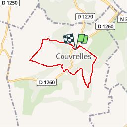
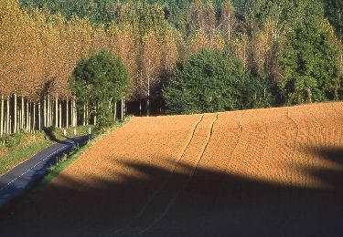
Trail Walking of 5.2 km to be discovered at Hauts-de-France, Aisne, Couvrelles. This trail is proposed by tracegps.
Description
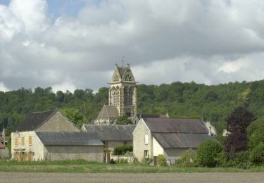
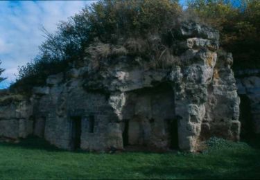
Village-rue, allongé en fond de vallée, Couvrelles reste marqué par son passé vigneron. Ce circuit permet de découvrir la ferme fortifiée de la Siège. Toutes les infos sont ICI
Positioning
Country:
France
Region :
Hauts-de-France
Department/Province :
Aisne
Municipality :
Couvrelles
Location:
Unknown
Start:(Dec)
Start:(UTM)
535564 ; 5465389 (31U) N.
Comments
Trails nearby
![Trail Walking Chassemy - Chassemy - Le temps perdu - Photo](https://media.geolcdn.com/t/375/260/ext.jpg?maxdim=2&url=https%3A%2F%2Fservices.sitytrail.com%2FGeolivesWS%2FDownloadMedia.ashx%3FTrailID%3D110394%26Media%3D5850_1.jpg)
![Walking Walking](https://static1.geolcdn.com/sitytour/trail-icons/101.png)
Chassemy - Le temps perdu
Walking
Medium
Chassemy,
Hauts-de-France,
Aisne,
France
![](/images/other/stat-length.png)
14.3 km | 17.5 km-effort
3h 45min
![](https://static1.geolcdn.com/siteimages/upload/files/16400158638029165_repeat_loop_refresh_sync_direction_icon.png)
Yes
![Trail Walking Braine - La Folie - Photo](https://media.geolcdn.com/t/375/260/ext.jpg?maxdim=2&url=https%3A%2F%2Fservices.sitytrail.com%2FGeolivesWS%2FDownloadMedia.ashx%3FTrailID%3D108440%26Media%3D1143_1.jpg)
![Walking Walking](https://static1.geolcdn.com/sitytour/trail-icons/101.png)
La Folie
Walking
Very difficult
(1)
Braine,
Hauts-de-France,
Aisne,
France
![](/images/other/stat-length.png)
8.4 km | 10.6 km-effort
3h 0min
![](https://static1.geolcdn.com/siteimages/upload/files/16400158638029165_repeat_loop_refresh_sync_direction_icon.png)
Yes
![Trail Walking Couvrelles - Les échauguettes - Photo](https://media.geolcdn.com/t/375/260/ext.jpg?maxdim=2&url=https%3A%2F%2Fservices.sitytrail.com%2FGeolivesWS%2FDownloadMedia.ashx%3FTrailID%3D108411%26Media%3D1095_2.jpg)
![Walking Walking](https://static1.geolcdn.com/sitytour/trail-icons/101.png)
Les échauguettes
Walking
Very difficult
Couvrelles,
Hauts-de-France,
Aisne,
France
![](/images/other/stat-length.png)
9.4 km | 12 km-effort
3h 0min
![](https://static1.geolcdn.com/siteimages/upload/files/16400158638029165_repeat_loop_refresh_sync_direction_icon.png)
Yes
![Trail Walking Nampteuil-sous-Muret - Les deux sources de la Crise - Photo](https://media.geolcdn.com/t/375/260/ext.jpg?maxdim=2&url=https%3A%2F%2Fservices.sitytrail.com%2FGeolivesWS%2FDownloadMedia.ashx%3FTrailID%3D108358%26Media%3D1034_2.jpg)
![Walking Walking](https://static1.geolcdn.com/sitytour/trail-icons/101.png)
Les deux sources de la Crise
Walking
Very difficult
(1)
Nampteuil-sous-Muret,
Hauts-de-France,
Aisne,
France
![](/images/other/stat-length.png)
11.9 km | 14.5 km-effort
4h 0min
![](https://static1.geolcdn.com/siteimages/upload/files/16400158638029165_repeat_loop_refresh_sync_direction_icon.png)
Yes
![Trail Walking Nampteuil-sous-Muret - Du marais au Coteau - Photo](https://media.geolcdn.com/t/375/260/ext.jpg?maxdim=2&url=https%3A%2F%2Fservices.sitytrail.com%2FGeolivesWS%2FDownloadMedia.ashx%3FTrailID%3D108338%26Media%3D1009_2.jpg)
![Walking Walking](https://static1.geolcdn.com/sitytour/trail-icons/101.png)
Du marais au Coteau
Walking
Medium
Nampteuil-sous-Muret,
Hauts-de-France,
Aisne,
France
![](/images/other/stat-length.png)
5.2 km | 6.4 km-effort
1h 30min
![](https://static1.geolcdn.com/siteimages/upload/files/16400158638029165_repeat_loop_refresh_sync_direction_icon.png)
Yes
![Trail Walking Nampteuil-sous-Muret - rando avec ados IME - Photo](https://media.geolcdn.com/t/375/260/ext.jpg?maxdim=2&url=https%3A%2F%2Fstatic1.geolcdn.com%2Fsiteimages%2Fupload%2Ffiles%2F1553511878bg_sport_marche.png)
![Walking Walking](https://static1.geolcdn.com/sitytour/trail-icons/101.png)
rando avec ados IME
Walking
Medium
Nampteuil-sous-Muret,
Hauts-de-France,
Aisne,
France
![](/images/other/stat-length.png)
9 km | 10.8 km-effort
3h 32min
![](https://static1.geolcdn.com/siteimages/upload/files/16400158638029165_repeat_loop_refresh_sync_direction_icon.png)
Yes
![Trail Walking Braine - mont notre dame - Photo](https://media.geolcdn.com/t/375/260/ext.jpg?maxdim=2&url=https%3A%2F%2Fstatic1.geolcdn.com%2Fsiteimages%2Fupload%2Ffiles%2F1553511878bg_sport_marche.png)
![Walking Walking](https://static1.geolcdn.com/sitytour/trail-icons/101.png)
mont notre dame
Walking
Difficult
Braine,
Hauts-de-France,
Aisne,
France
![](/images/other/stat-length.png)
31 km | 37 km-effort
6h 40min
![](https://static1.geolcdn.com/siteimages/upload/files/16400158638029165_repeat_loop_refresh_sync_direction_icon.png)
No
![Trail Walking Nampteuil-sous-Muret - Du marais au côteau - Photo](https://media.geolcdn.com/t/375/260/ext.jpg?maxdim=2&url=https%3A%2F%2Fservices.sitytrail.com%2FGeolivesWS%2FDownloadMedia.ashx%3FTrailID%3D202813%26Media%3D88a53e98-9413-4684-8b02-37a2da12d04e.jpg)
![Walking Walking](https://static1.geolcdn.com/sitytour/trail-icons/101.png)
Du marais au côteau
Walking
Very easy
Nampteuil-sous-Muret,
Hauts-de-France,
Aisne,
France
![](/images/other/stat-length.png)
5.2 km | 6.3 km-effort
Unknown
![](https://static1.geolcdn.com/siteimages/upload/files/16400158638029165_repeat_loop_refresh_sync_direction_icon.png)
Yes
![Trail Walking Couvrelles - Les échauguettes - variante 2 - Photo](https://media.geolcdn.com/t/375/260/ext.jpg?maxdim=2&url=https%3A%2F%2Fstatic1.geolcdn.com%2Fsiteimages%2Fupload%2Ffiles%2F1553511878bg_sport_marche.png)
![Walking Walking](https://static1.geolcdn.com/sitytour/trail-icons/101.png)
Les échauguettes - variante 2
Walking
Medium
(2)
Couvrelles,
Hauts-de-France,
Aisne,
France
![](/images/other/stat-length.png)
15 km | 19.1 km-effort
1h 30min
![](https://static1.geolcdn.com/siteimages/upload/files/16400158638029165_repeat_loop_refresh_sync_direction_icon.png)
Yes