Trail Walking Soupir - Au fil du val de l'Aisne - Photo

Au fil du val de l'Aisne

 tracegps
tracegps

User

© OpenStreetMap contributors
Length
Length
11.4 km
Max alt
Max alt
177 m
Uphill gradient
Uphill gradient
248 m
Km-Effort
Km-Effort  
14.7 km
Min alt
Min alt
41 m
Downhill gradient
Downhill gradient
246 m
Boucle
Boucle
Yes
Creation date :
2014-12-10 00:00:00.0
Updated on :
2014-12-10 00:00:00.0

(0 Reviews)

Walking
Walking
3h30
Difficulty : Very difficult

Scan this QR Code to open this trail in the SityTrail application

FREE GPS app for hiking

Logo SityTrail SityTrail

IGN / Geographical institutes

Download SityTrail from the App Store Download SityTrail from Google Play

Logo SityTrail SityTrail World

The world is yours!

Download SityTrail from the App Store Download SityTrail from Google Play Download SityTrail on Huawei AppGallery

About

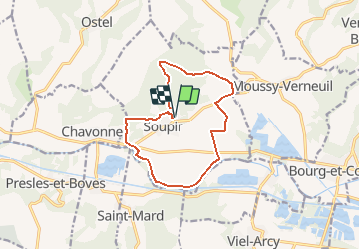
Trail Walking of 11.4 km to be discovered at Hauts-de-France, Aisne, Soupir. This trail is proposed by tracegps.

Description

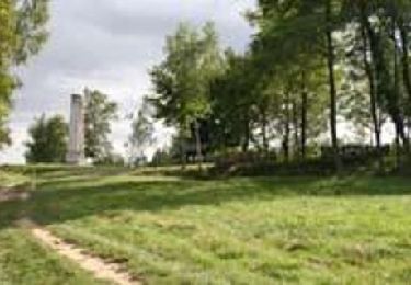
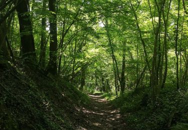
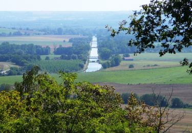
Outre une étrange porte de château et une église classée, Soupir regroupe quatre cimetières militaires de nationalités différentes. La variante permet d'embrasser d'un seul regard toute la vallée de l'Aisne et ses villages. Toutes les infos sont ICI

Elevation profile

Photos

Positioning

Country:
France
Region :
Hauts-de-France
Department/Province :
Aisne
Municipality :
Soupir
Location:
Unknown
Start:(UTM)
543397 ; 5473023 (31U) N.

Trails nearby

Trail Walking Bourg-et-Comin - Les villages troglodytiques - variante - Photo
Walking
tracegps

Walking

Medium
(1)
Bourg-et-Comin, Hauts-de-France, Aisne, France
19.5 km | 24 km-effort
1h 0min
Yes
Trail Walking Braye-en-Laonnois - Le tunnel du Chemin des Dames - Photo
Walking

Walking

Very easy
Braye-en-Laonnois, Hauts-de-France, Aisne, France
4.8 km | 6.8 km-effort
Unknown
Yes
Trail Walking Bourg-et-Comin - Bourg Comin Paissy troglodytes  - Photo
Walking
ZITO12

Walking

Medium
Bourg-et-Comin, Hauts-de-France, Aisne, France
16 km | 19.4 km-effort
4h 14min
Yes
Trail Mountain bike Bourg-et-Comin - Le Chemin des Eclusiers - Photo
Mountain bike
tracegps

Mountain bike

Difficult
Bourg-et-Comin, Hauts-de-France, Aisne, France
19.2 km | 24 km-effort
5h 30min
Yes
Trail Walking Bourg-et-Comin - Le Pont Canal ( de l'Oise) - Photo
Walking
tracegps

Walking

Medium
Bourg-et-Comin, Hauts-de-France, Aisne, France
11.4 km | 13.9 km-effort
4h 0min
Yes
Trail Walking Braye-en-Laonnois - Le tunnel du Chemin des Dames - variante - Photo
Walking
tracegps

Walking

Medium
Braye-en-Laonnois, Hauts-de-France, Aisne, France
9.4 km | 12.1 km-effort
3h 0min
Yes
Trail Walking Braye-en-Laonnois - Le tunnel du Chemin des Dames - Photo
Walking
tracegps

Walking

Medium
(1)
Braye-en-Laonnois, Hauts-de-France, Aisne, France
4.8 km | 6.8 km-effort
1h 30min
Yes
Trail Mountain bike Bourg-et-Comin - Les villages troglodytiques - Photo
Mountain bike
tracegps

Mountain bike

Very difficult
Bourg-et-Comin, Hauts-de-France, Aisne, France
19.5 km | 24 km-effort
3h 15min
Yes
Trail Walking Bourg-et-Comin - Les villages troglodytiques - Photo
Walking
tracegps

Walking

Very difficult
(1)
Bourg-et-Comin, Hauts-de-France, Aisne, France
15.1 km | 18.4 km-effort
5h 0min
Yes


Close
My subscriptions