![](/images/other/stat-length.png)
![Trail Walking Marly-Gomont - La fontaine Colette - Photo](https://media.geolcdn.com/t/1900/400/ext.pjpeg?maxdim=2&url=https%3A%2F%2Fservices.sitytrail.com%2FGeolivesWS%2FDownloadMedia.ashx%3FTrailID%3D108298%26Media%3D969_2.jpg)
La fontaine Colette
tracegps
User
![Length](/images/other/stat-length.png)
Length
9.6 km
![Max alt](https://static1.geolcdn.com/siteimages/upload/files/1508320355ic_sort_altitude_max_24dp.png)
Max alt
170 m
![Uphill gradient](https://static1.geolcdn.com/siteimages/upload/files/1508320355ic_sort_den_pos_24dp.png)
Uphill gradient
124 m
![Km-Effort](/images/other/stat-length.png)
Km-Effort
11.2 km
![Min alt](https://static1.geolcdn.com/siteimages/upload/files/1508320355ic_sort_altitude_min_24dp.png)
Min alt
109 m
![Downhill gradient](https://static1.geolcdn.com/siteimages/upload/files/1508320355ic_sort_den_neg_24dp.png)
Downhill gradient
124 m
![Boucle](https://static1.geolcdn.com/siteimages/upload/files/16400158638029165_repeat_loop_refresh_sync_direction_icon.png)
Boucle
Yes
Creation date :
2014-12-10 00:00:00.0
Updated on :
2014-12-10 00:00:00.0
![Walking](https://static1.geolcdn.com/sitytour/trail-icons/101.png)
2h45
Difficulty : Medium
![Scan this QR Code to open this trail in the SityTrail application](https://capi.geolives.com/qq0zvz2zws4bq2lad0pu/sitytour/trails/108298/qr.png?size=200)
FREE GPS app for hiking
About
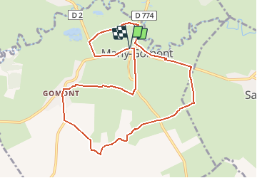
Trail Walking of 9.6 km to be discovered at Hauts-de-France, Aisne, Marly-Gomont. This trail is proposed by tracegps.
Description
Marly-Gomont était réputé pour sa vannerie, mais c'est essentiellement pour le plaisir de cheminer sur des sentiers sauvages, entre champs et pâturages, que nous vous avons concocté cet itinéraire bocager, mouillé çà et là par l'Oise sinueuse. Toutes les infos sont ICI
Positioning
Country:
France
Region :
Hauts-de-France
Department/Province :
Aisne
Municipality :
Marly-Gomont
Location:
Unknown
Start:(Dec)
Start:(UTM)
556786 ; 5528458 (31U) N.
Comments
Trails nearby
![Trail Walking Englancourt - ENGLANCOURT - AISNE - Photo](https://media.geolcdn.com/t/375/260/14c41585-1596-4633-ac04-daedca55e346.jpg&format=jpg&maxdim=2)
![Walking Walking](https://static1.geolcdn.com/sitytour/trail-icons/101.png)
ENGLANCOURT - AISNE
Walking
Easy
Englancourt,
Hauts-de-France,
Aisne,
France
![](/images/other/stat-length.png)
11 km | 13.1 km-effort
2h 2min
![](https://static1.geolcdn.com/siteimages/upload/files/16400158638029165_repeat_loop_refresh_sync_direction_icon.png)
Yes
![Trail Walking Marly-Gomont - Axe vert de Thiérache 2 - Photo](https://media.geolcdn.com/t/375/260/ext.jpg?maxdim=2&url=https%3A%2F%2Fservices.sitytrail.com%2FGeolivesWS%2FDownloadMedia.ashx%3FTrailID%3D108764%26Media%3D1881_1.jpg)
![Walking Walking](https://static1.geolcdn.com/sitytour/trail-icons/101.png)
Axe vert de Thiérache 2
Walking
Medium
Marly-Gomont,
Hauts-de-France,
Aisne,
France
![](/images/other/stat-length.png)
10.9 km | 11.9 km-effort
3h 0min
![](https://static1.geolcdn.com/siteimages/upload/files/16400158638029165_repeat_loop_refresh_sync_direction_icon.png)
No
![Trail Walking Marly-Gomont - La fontaine Colette - Photo](https://media.geolcdn.com/t/375/260/ext.jpg?maxdim=2&url=https%3A%2F%2Fservices.sitytrail.com%2FGeolivesWS%2FDownloadMedia.ashx%3FTrailID%3D202822%26Media%3D1f079df0-4c36-494f-a396-afdaa4df4298.jpg)
![Walking Walking](https://static1.geolcdn.com/sitytour/trail-icons/101.png)
La fontaine Colette
Walking
Very easy
Marly-Gomont,
Hauts-de-France,
Aisne,
France
![](/images/other/stat-length.png)
9.6 km | 11.2 km-effort
Unknown
![](https://static1.geolcdn.com/siteimages/upload/files/16400158638029165_repeat_loop_refresh_sync_direction_icon.png)
Yes
![Trail Walking Marly-Gomont - Marly gomont - Photo](https://media.geolcdn.com/t/375/260/ext.jpg?maxdim=2&url=https%3A%2F%2Fstatic1.geolcdn.com%2Fsiteimages%2Fupload%2Ffiles%2F1553511878bg_sport_marche.png)
![Walking Walking](https://static1.geolcdn.com/sitytour/trail-icons/101.png)
Marly gomont
Walking
Very easy
Marly-Gomont,
Hauts-de-France,
Aisne,
France
![](/images/other/stat-length.png)
11.1 km | 13 km-effort
2h 47min
![](https://static1.geolcdn.com/siteimages/upload/files/16400158638029165_repeat_loop_refresh_sync_direction_icon.png)
Yes
![Trail Road bike Marly-Gomont - vélo marly gomont guise - Photo](https://media.geolcdn.com/t/375/260/ext.jpg?maxdim=2&url=https%3A%2F%2Fstatic1.geolcdn.com%2Fsiteimages%2Fupload%2Ffiles%2F1524743154velo.jpg)
![Road bike Road bike](https://static1.geolcdn.com/sitytour/trail-icons/201.png)
vélo marly gomont guise
Road bike
Very easy
Marly-Gomont,
Hauts-de-France,
Aisne,
France
![](/images/other/stat-length.png)
19.4 km | 23 km-effort
1h 33min
![](https://static1.geolcdn.com/siteimages/upload/files/16400158638029165_repeat_loop_refresh_sync_direction_icon.png)
No