![](/images/other/stat-length.png)
![Trail Walking Saint-Quentin - Le marais d'Isle - Photo](https://media.geolcdn.com/t/1900/400/ext.pjpeg?maxdim=2&url=https%3A%2F%2Fservices.sitytrail.com%2FGeolivesWS%2FDownloadMedia.ashx%3FTrailID%3D108285%26Media%3D956_2.jpg)
Le marais d'Isle
tracegps
User
![Length](/images/other/stat-length.png)
![Max alt](https://static1.geolcdn.com/siteimages/upload/files/1508320355ic_sort_altitude_max_24dp.png)
![Uphill gradient](https://static1.geolcdn.com/siteimages/upload/files/1508320355ic_sort_den_pos_24dp.png)
![Km-Effort](/images/other/stat-length.png)
![Min alt](https://static1.geolcdn.com/siteimages/upload/files/1508320355ic_sort_altitude_min_24dp.png)
![Downhill gradient](https://static1.geolcdn.com/siteimages/upload/files/1508320355ic_sort_den_neg_24dp.png)
![Boucle](https://static1.geolcdn.com/siteimages/upload/files/16400158638029165_repeat_loop_refresh_sync_direction_icon.png)
![Walking](https://static1.geolcdn.com/sitytour/trail-icons/101.png)
1h30
Difficulty : Easy
![Scan this QR Code to open this trail in the SityTrail application](https://capi.geolives.com/qq0zvz2zws4bq2lad0pu/sitytour/trails/108285/qr.png?size=200)
FREE GPS app for hiking
About
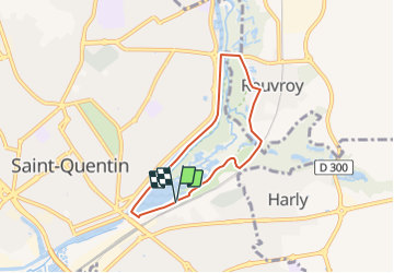
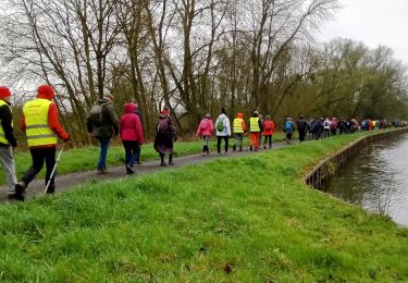
Trail Walking of 5.4 km to be discovered at Hauts-de-France, Aisne, Saint-Quentin. This trail is proposed by tracegps.
Description
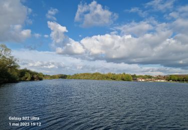
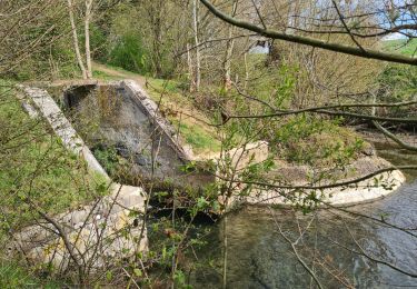
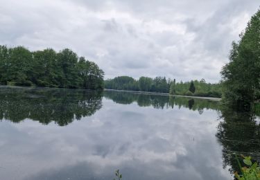
Ce parcours familial (aire de jeux, base de loisirs en saison) autour de la réserve naturelle d'Isle permet d'approcher l'étang et la zone humide des marais, réservoir écologique au cœur de la cité industrieuse. Attention, la variante est ouverte seulement l'après-midi. Toutes les infos sont ICI
Positioning
Comments
Trails nearby
![Trail Mountain bike Mesnil-Saint-Laurent - mesnil-fresnoy le grand-montbrehain -lesdits - Photo](https://media.geolcdn.com/t/375/260/921c065c-1c8e-48a6-9b6e-48c09ce62a81.jpg&format=jpg&maxdim=2)
![Mountain bike Mountain bike](https://static1.geolcdn.com/sitytour/trail-icons/202.png)
Mountain bike
![](/images/other/stat-length.png)
![](https://static1.geolcdn.com/siteimages/upload/files/16400158638029165_repeat_loop_refresh_sync_direction_icon.png)
![Trail Mountain bike Dallon - pays de ham - Photo](https://media.geolcdn.com/t/375/260/995bec17-ed2a-487a-95fa-9605ac514751.jpg&format=jpg&maxdim=2)
![Mountain bike Mountain bike](https://static1.geolcdn.com/sitytour/trail-icons/202.png)
Mountain bike
![](/images/other/stat-length.png)
![](https://static1.geolcdn.com/siteimages/upload/files/16400158638029165_repeat_loop_refresh_sync_direction_icon.png)
![Trail Mountain bike Mesnil-Saint-Laurent - parcours mesnil thenelles- beautor- Mennessis - Photo](https://media.geolcdn.com/t/375/260/70ed0656-c563-4ffb-b89a-fd24f69ca65a.jpg&format=jpg&maxdim=2)
![Mountain bike Mountain bike](https://static1.geolcdn.com/sitytour/trail-icons/202.png)
Mountain bike
![](/images/other/stat-length.png)
![](https://static1.geolcdn.com/siteimages/upload/files/16400158638029165_repeat_loop_refresh_sync_direction_icon.png)
![Trail Walking Rouvroy - circuit rouvroy fonsomme croix fonsommes - Photo](https://media.geolcdn.com/t/375/260/5e50172e-7db2-4492-8abc-36f32572f710.jpg&format=jpg&maxdim=2)
![Walking Walking](https://static1.geolcdn.com/sitytour/trail-icons/101.png)
Walking
![](/images/other/stat-length.png)
![](https://static1.geolcdn.com/siteimages/upload/files/16400158638029165_repeat_loop_refresh_sync_direction_icon.png)
![Trail Walking Homblières - homblières Fonsomme - Photo](https://media.geolcdn.com/t/375/260/70887b79-816c-4f1e-8bca-6acf631404c6.jpg&format=jpg&maxdim=2)
![Walking Walking](https://static1.geolcdn.com/sitytour/trail-icons/101.png)
Walking
![](/images/other/stat-length.png)
![](https://static1.geolcdn.com/siteimages/upload/files/16400158638029165_repeat_loop_refresh_sync_direction_icon.png)
![Trail Walking Saint-Quentin - Le marais d'Isle - Photo](https://media.geolcdn.com/t/375/260/ext.jpg?maxdim=2&url=https%3A%2F%2Fservices.sitytrail.com%2FGeolivesWS%2FDownloadMedia.ashx%3FTrailID%3D202837%26Media%3D6430a4b8-690f-47d6-9bb9-9c084dd5e5b9.jpg)
![Walking Walking](https://static1.geolcdn.com/sitytour/trail-icons/101.png)
Walking
![](/images/other/stat-length.png)
![](https://static1.geolcdn.com/siteimages/upload/files/16400158638029165_repeat_loop_refresh_sync_direction_icon.png)
![Trail Mountain bike Mesnil-Saint-Laurent - mesnil - Vendeuil - Photo](https://media.geolcdn.com/t/375/260/acf1356d-e8bd-45d7-a575-aeb25f0ccc16.jpg&format=jpg&maxdim=2)
![Mountain bike Mountain bike](https://static1.geolcdn.com/sitytour/trail-icons/202.png)
Mountain bike
![](/images/other/stat-length.png)
![](https://static1.geolcdn.com/siteimages/upload/files/16400158638029165_repeat_loop_refresh_sync_direction_icon.png)
![Trail Walking Castres - Castres du 02-04-2023 après midi - Photo](https://media.geolcdn.com/t/375/260/2c9aff69-d2ff-40ee-aa65-6a110533a96b.jpg&format=jpg&maxdim=2)
![Walking Walking](https://static1.geolcdn.com/sitytour/trail-icons/101.png)
Walking
![](/images/other/stat-length.png)
![](https://static1.geolcdn.com/siteimages/upload/files/16400158638029165_repeat_loop_refresh_sync_direction_icon.png)
![Trail Walking Castres - Castres du 02-04-2023 le matin - Photo](https://media.geolcdn.com/t/375/260/dc3c9b9d-7f93-490d-87f5-88d7a975468d.jpg&format=jpg&maxdim=2)
![Walking Walking](https://static1.geolcdn.com/sitytour/trail-icons/101.png)
Walking
![](/images/other/stat-length.png)
![](https://static1.geolcdn.com/siteimages/upload/files/16400158638029165_repeat_loop_refresh_sync_direction_icon.png)