Trail Equestrian Saint-Quirc - Saint-Quirc - Saverdun - Photo

Saint-Quirc - Saverdun

 tracegps
tracegps

User

© OpenStreetMap contributors
Length
Length
17.2 km
Max alt
Max alt
367 m
Uphill gradient
Uphill gradient
414 m
Km-Effort
Km-Effort  
23 km
Min alt
Min alt
217 m
Downhill gradient
Downhill gradient
393 m
Boucle
Boucle
No
Creation date :
2014-12-10 00:00:00.0
Updated on :
2014-12-10 00:00:00.0

(0 Reviews)

Equestrian
Equestrian
2h00
Difficulty : Difficult

Scan this QR Code to open this trail in the SityTrail application

FREE GPS app for hiking

Logo SityTrail SityTrail

IGN / Geographical institutes

Download SityTrail from the App Store Download SityTrail from Google Play

Logo SityTrail SityTrail World

The world is yours!

Download SityTrail from the App Store Download SityTrail from Google Play Download SityTrail on Huawei AppGallery

About

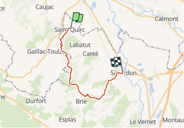
Trail Equestrian of 17.2 km to be discovered at Occitania, Ariège, Saint-Quirc. This trail is proposed by tracegps.

Description

Superbe balade proposée par le Bureau des Guides Équestres Transpyrénéens

Elevation profile

Photos

Positioning

Country:
France
Region :
Occitania
Department/Province :
Ariège
Municipality :
Saint-Quirc
Location:
Unknown
Start:(UTM)
378633 ; 4792624 (31T) N.

Trails nearby

Trail Walking Grazac - Randonnée à Grazac - Photo
Walking
tracegps

Walking

Medium
Grazac, Occitania, Haute-Garonne, France
21 km | 26 km-effort
6h 0min
Yes
Trail Walking Grazac - grazac grand bosc - Photo
Walking
Bernard24

Walking

Medium
Grazac, Occitania, Haute-Garonne, France
8.3 km | 10.6 km-effort
2h 50min
Yes
Trail Walking Canté - al - Photo
Walking
ClubAgeHeureux

Walking

Very easy
Canté, Occitania, Ariège, France
9.4 km | 11.9 km-effort
2h 13min
Yes
Trail Walking Caujac - caujac fait - Photo
Walking
pidjam

Walking

Easy
(1)
Caujac, Occitania, Haute-Garonne, France
9.5 km | 11.8 km-effort
2h 35min
Yes
Trail Walking Lissac - Lissac les eucalyptus - Photo
Walking
pidjam

Walking

Easy
Lissac, Occitania, Ariège, France
11.3 km | 14.2 km-effort
3h 5min
Yes
Trail Walking Gaillac-Toulza - GAILLAC TOULZA - Photo
Walking
DEDIEUJ

Walking

Medium
Gaillac-Toulza, Occitania, Haute-Garonne, France
16.8 km | 22 km-effort
4h 45min
Yes
Trail Walking Caujac - Circuit CAUJAC - Photo
Walking
DEDIEUJ

Walking

Medium
Caujac, Occitania, Haute-Garonne, France
8.4 km | 10.8 km-effort
2h 18min
Yes
Trail Running Cintegabelle - cintegabelle avec les cousines - Photo
Running
yt34

Running

Very easy
Cintegabelle, Occitania, Haute-Garonne, France
8.5 km | 10 km-effort
57min
Yes
Trail Walking Cintegabelle - Alain Cintegabelle bleu courte 2024 - Photo
Walking
ClubAgeHeureux

Walking

Medium
Cintegabelle, Occitania, Haute-Garonne, France
7.2 km | 9 km-effort
1h 44min
Yes


Close
My subscriptions