Trail Nordic walking Bénac - la pierre du diable  - Photo

la pierre du diable

 GIRAUDEL
GIRAUDEL

User

© OpenStreetMap contributors
Length
Length
7.9 km
Max alt
Max alt
491 m
Uphill gradient
Uphill gradient
246 m
Km-Effort
Km-Effort  
11.2 km
Min alt
Min alt
351 m
Downhill gradient
Downhill gradient
246 m
Boucle
Boucle
Yes
Creation date :
2019-01-15 19:35:47.088
Updated on :
2019-01-15 19:35:47.088

(0 Reviews)

Nordic walking
Nordic walking
2h00
Difficulty : Easy

Scan this QR Code to open this trail in the SityTrail application

FREE GPS app for hiking

Logo SityTrail SityTrail

IGN / Geographical institutes

Download SityTrail from the App Store Download SityTrail from Google Play

Logo SityTrail SityTrail World

The world is yours!

Download SityTrail from the App Store Download SityTrail from Google Play Download SityTrail on Huawei AppGallery

About

Trail Nordic walking of 7.9 km to be discovered at Occitania, Hautespyrenees, Bénac. This trail is proposed by GIRAUDEL.

Description

départ parking Bénac place principale
entrée de Visker Layrisse
pierre du diable à voir à la sortiede Layrisse hord itinéraire 50 m

Elevation profile

Positioning

Country:
France
Region :
Occitania
Department/Province :
Hautespyrenees
Municipality :
Bénac
Location:
Unknown
Start:(UTM)
258239 ; 4782213 (31T) N.

Trails nearby

Trail On foot Lanne - Le Chemin des Crêtes - Photo
On foot
GUIDE+

On foot

Easy
Lanne, Occitania, Hautespyrenees, France
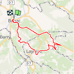
11.4 km | 14.4 km-effort
3h 16min
Yes
Trail Other activity Lanne - Averan les crêtes court - Photo
Other activity
GIRAUDEL

Other activity

Easy
(1)
Lanne, Occitania, Hautespyrenees, France
10 km | 12.6 km-effort
2h 20min
Yes
Trail Nordic walking Horgues - Horgues Odos - Photo
Nordic walking
GIRAUDEL

Nordic walking

Easy
Horgues, Occitania, Hautespyrenees, France
9.1 km | 9.8 km-effort
2h 3min
Yes
Trail Nordic walking Juillan - juillan hibarette louey  - Photo
Nordic walking
Loucha

Nordic walking

Very easy
Juillan, Occitania, Hautespyrenees, France
7.7 km | 9.6 km-effort
1h 38min
Yes
Trail Walking Orincles - Les chemins de Loucrup - Photo
Walking
GIRAUDEL

Walking

Easy
Orincles, Occitania, Hautespyrenees, France
9.4 km | 12.5 km-effort
2h 49min
Yes
Trail On foot Barry - -Barry - Miramont - Photo
On foot
mitch1952

On foot

Easy
Barry, Occitania, Hautespyrenees, France
9.9 km | 14.1 km-effort
3h 12min
Yes
Trail On foot Adé - G3 Ail des Ours et Miramont - Photo
On foot
mitch1952

On foot

Easy
Adé, Occitania, Hautespyrenees, France
11.7 km | 16.7 km-effort
3h 48min
Yes
Trail On foot Lanne - 2021-05-02 16:57:34 - Photo
On foot
mitch1952

On foot

Medium
Lanne, Occitania, Hautespyrenees, France
18.6 km | 25 km-effort
5h 42min
Yes
Trail On foot Lanne - 2021-04-16 16:42:06 - Photo
On foot
mitch1952

On foot

Medium
Lanne, Occitania, Hautespyrenees, France
21 km | 30 km-effort
6h 48min
Yes


Close
My subscriptions