![](/images/other/stat-length.png)
![Trail Walking Chindrieux - 2018-12-05 Boucle Rochetaillée - Photo](https://media.geolcdn.com/t/1900/400/ext.pjpeg?maxdim=2&url=https%3A%2F%2Fstatic1.geolcdn.com%2Fsiteimages%2Fupload%2Ffiles%2F1553511878bg_sport_marche.png)
2018-12-05 Boucle Rochetaillée
patpounet73
User
![Length](/images/other/stat-length.png)
Length
5.9 km
![Max alt](https://static1.geolcdn.com/siteimages/upload/files/1508320355ic_sort_altitude_max_24dp.png)
Max alt
470 m
![Uphill gradient](https://static1.geolcdn.com/siteimages/upload/files/1508320355ic_sort_den_pos_24dp.png)
Uphill gradient
301 m
![Km-Effort](/images/other/stat-length.png)
Km-Effort
9.9 km
![Min alt](https://static1.geolcdn.com/siteimages/upload/files/1508320355ic_sort_altitude_min_24dp.png)
Min alt
297 m
![Downhill gradient](https://static1.geolcdn.com/siteimages/upload/files/1508320355ic_sort_den_neg_24dp.png)
Downhill gradient
299 m
![Boucle](https://static1.geolcdn.com/siteimages/upload/files/16400158638029165_repeat_loop_refresh_sync_direction_icon.png)
Boucle
Yes
Creation date :
2019-01-15 19:34:47.376
Updated on :
2019-01-15 19:34:47.376
![Walking](https://static1.geolcdn.com/sitytour/trail-icons/101.png)
2h00
Difficulty : Easy
![Scan this QR Code to open this trail in the SityTrail application](https://capi.geolives.com/qq0zvz2zws4bq2lad0pu/sitytour/trails/1081037/qr.png?size=200)
FREE GPS app for hiking
About
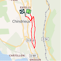
Trail Walking of 5.9 km to be discovered at Auvergne-Rhône-Alpes, Savoy, Chindrieux. This trail is proposed by patpounet73.
Description
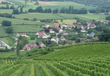
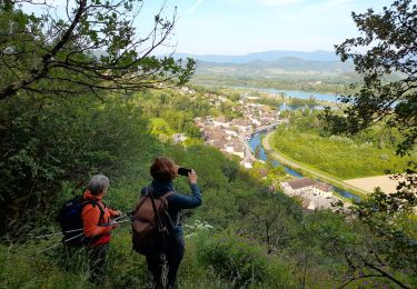
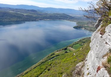
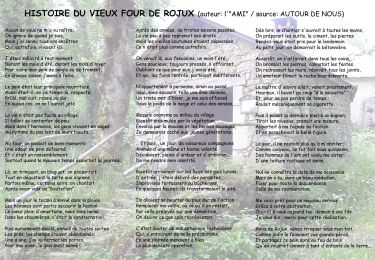
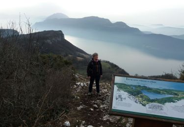
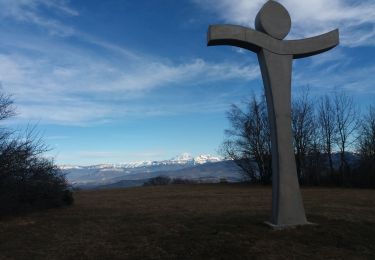
Randonnée facile avec de jolis points de vue sur le lac du Bourget. Un aller retour à la croix de Beauvoir et sa plate forme aménagée permet d'admirer un beau panorama.
Positioning
Country:
France
Region :
Auvergne-Rhône-Alpes
Department/Province :
Savoy
Municipality :
Chindrieux
Location:
Unknown
Start:(Dec)
Start:(UTM)
721476 ; 5078165 (31T) N.
Comments
Trails nearby
![Trail Walking Chindrieux - Sur les Pas des Huguenots - Chindrieux - Serrières en Chautagne - Photo](https://media.geolcdn.com/t/375/260/ext.jpg?maxdim=2&url=https%3A%2F%2Fservices.sitytrail.com%2FGeolivesWS%2FDownloadMedia.ashx%3FTrailID%3D129664%26Media%3D13193_3.jpg)
![Walking Walking](https://static1.geolcdn.com/sitytour/trail-icons/101.png)
Sur les Pas des Huguenots - Chindrieux - Serrières en Chautagne
Walking
Medium
(1)
Chindrieux,
Auvergne-Rhône-Alpes,
Savoy,
France
![](/images/other/stat-length.png)
9.2 km | 13.8 km-effort
3h 0min
![](https://static1.geolcdn.com/siteimages/upload/files/16400158638029165_repeat_loop_refresh_sync_direction_icon.png)
No
![Trail Walking Massingy - CLERGEON - Photo](https://media.geolcdn.com/t/375/260/ext.jpg?maxdim=2&url=https%3A%2F%2Fservices.sitytrail.com%2FGeolivesWS%2FDownloadMedia.ashx%3FTrailID%3D474185%26Media%3Dc01eb5a7-bf72-4ffc-98fa-1e923f8f3f43.jpg)
![Walking Walking](https://static1.geolcdn.com/sitytour/trail-icons/101.png)
CLERGEON
Walking
Easy
Massingy,
Auvergne-Rhône-Alpes,
Upper Savoy,
France
![](/images/other/stat-length.png)
14.6 km | 22 km-effort
4h 41min
![](https://static1.geolcdn.com/siteimages/upload/files/16400158638029165_repeat_loop_refresh_sync_direction_icon.png)
Yes
![Trail Walking Entrelacs - SAPENAY / CLERGEON: GRANDE CUVE - Photo](https://media.geolcdn.com/t/375/260/81ea709e-f7b9-477c-93c3-923ab4e12c63.jpg&format=jpg&maxdim=2)
![Walking Walking](https://static1.geolcdn.com/sitytour/trail-icons/101.png)
SAPENAY / CLERGEON: GRANDE CUVE
Walking
Very difficult
Entrelacs,
Auvergne-Rhône-Alpes,
Savoy,
France
![](/images/other/stat-length.png)
14.1 km | 21 km-effort
4h 45min
![](https://static1.geolcdn.com/siteimages/upload/files/16400158638029165_repeat_loop_refresh_sync_direction_icon.png)
Yes
![Trail Walking Entrelacs - La chambotte mont laval aix les bains - Photo](https://media.geolcdn.com/t/375/260/83780321-69f1-4ca1-9229-55e6ffa1c410.jpg&format=jpg&maxdim=2)
![Walking Walking](https://static1.geolcdn.com/sitytour/trail-icons/101.png)
La chambotte mont laval aix les bains
Walking
Easy
Entrelacs,
Auvergne-Rhône-Alpes,
Savoy,
France
![](/images/other/stat-length.png)
5.6 km | 8.9 km-effort
2h 24min
![](https://static1.geolcdn.com/siteimages/upload/files/16400158638029165_repeat_loop_refresh_sync_direction_icon.png)
Yes
![Trail Walking Chanaz - SAVOIE: CHANAZ - SAINT PIERRE DE CURTILLE - JONGIEUX - Photo](https://media.geolcdn.com/t/375/260/a2c9fd3e-2c40-420b-9198-d6795b6e7119.jpg&format=jpg&maxdim=2)
![Walking Walking](https://static1.geolcdn.com/sitytour/trail-icons/101.png)
SAVOIE: CHANAZ - SAINT PIERRE DE CURTILLE - JONGIEUX
Walking
Difficult
Chanaz,
Auvergne-Rhône-Alpes,
Savoy,
France
![](/images/other/stat-length.png)
26 km | 37 km-effort
8h 19min
![](https://static1.geolcdn.com/siteimages/upload/files/16400158638029165_repeat_loop_refresh_sync_direction_icon.png)
Yes
![Trail Walking Entrelacs - CHAMBOTTE: DECRASSAGE SUR LES CRETES - Photo](https://media.geolcdn.com/t/375/260/ddde69c3-3462-4077-ba6c-e835ee2db56d.jpg&format=jpg&maxdim=2)
![Walking Walking](https://static1.geolcdn.com/sitytour/trail-icons/101.png)
CHAMBOTTE: DECRASSAGE SUR LES CRETES
Walking
Easy
Entrelacs,
Auvergne-Rhône-Alpes,
Savoy,
France
![](/images/other/stat-length.png)
5.8 km | 9.4 km-effort
2h 0min
![](https://static1.geolcdn.com/siteimages/upload/files/16400158638029165_repeat_loop_refresh_sync_direction_icon.png)
Yes
![Trail Walking Chindrieux - SAPENAY / CLERGEON: COL DU SAPENAY - ROJUX - GRANDE CUVE - MONTCLERGEON - Photo](https://media.geolcdn.com/t/375/260/ec0fabdb-a998-4b52-ac46-d11021fde1e5.jpg&format=jpg&maxdim=2)
![Walking Walking](https://static1.geolcdn.com/sitytour/trail-icons/101.png)
SAPENAY / CLERGEON: COL DU SAPENAY - ROJUX - GRANDE CUVE - MONTCLERGEON
Walking
Medium
Chindrieux,
Auvergne-Rhône-Alpes,
Savoy,
France
![](/images/other/stat-length.png)
11.5 km | 15.6 km-effort
3h 15min
![](https://static1.geolcdn.com/siteimages/upload/files/16400158638029165_repeat_loop_refresh_sync_direction_icon.png)
Yes
![Trail Walking Entrelacs - SAPENAY: MONTAGNE DE CESSENS - Photo](https://media.geolcdn.com/t/375/260/cae53790-ce06-4ff8-a857-f0d1206d4970.jpg&format=jpg&maxdim=2)
![Walking Walking](https://static1.geolcdn.com/sitytour/trail-icons/101.png)
SAPENAY: MONTAGNE DE CESSENS
Walking
Easy
Entrelacs,
Auvergne-Rhône-Alpes,
Savoy,
France
![](/images/other/stat-length.png)
7.9 km | 12.2 km-effort
2h 35min
![](https://static1.geolcdn.com/siteimages/upload/files/16400158638029165_repeat_loop_refresh_sync_direction_icon.png)
Yes
![Trail Walking Chindrieux - SAPENAY / CLERGEON: COL DU SAPENAY - MONTCLERGEON PAR LE SENTIER DES VACHES (en live) - Photo](https://media.geolcdn.com/t/375/260/3c03cb4b-fb8a-4c79-83a1-ad8f3ccbc05c.jpg&format=jpg&maxdim=2)
![Walking Walking](https://static1.geolcdn.com/sitytour/trail-icons/101.png)
SAPENAY / CLERGEON: COL DU SAPENAY - MONTCLERGEON PAR LE SENTIER DES VACHES (...
Walking
Easy
Chindrieux,
Auvergne-Rhône-Alpes,
Savoy,
France
![](/images/other/stat-length.png)
8.9 km | 12.2 km-effort
2h 45min
![](https://static1.geolcdn.com/siteimages/upload/files/16400158638029165_repeat_loop_refresh_sync_direction_icon.png)
Yes