![](/images/other/stat-length.png)
![Trail Walking Besançon - trou au loup chabuis - Photo](https://media.geolcdn.com/t/1900/400/ext.pjpeg?maxdim=2&url=https%3A%2F%2Fstatic1.geolcdn.com%2Fsiteimages%2Fupload%2Ffiles%2F1553511878bg_sport_marche.png)
trou au loup chabuis
eltonnermou
User
![Length](/images/other/stat-length.png)
Length
9.4 km
![Max alt](https://static1.geolcdn.com/siteimages/upload/files/1508320355ic_sort_altitude_max_24dp.png)
Max alt
487 m
![Uphill gradient](https://static1.geolcdn.com/siteimages/upload/files/1508320355ic_sort_den_pos_24dp.png)
Uphill gradient
266 m
![Km-Effort](/images/other/stat-length.png)
Km-Effort
12.9 km
![Min alt](https://static1.geolcdn.com/siteimages/upload/files/1508320355ic_sort_altitude_min_24dp.png)
Min alt
338 m
![Downhill gradient](https://static1.geolcdn.com/siteimages/upload/files/1508320355ic_sort_den_neg_24dp.png)
Downhill gradient
266 m
![Boucle](https://static1.geolcdn.com/siteimages/upload/files/16400158638029165_repeat_loop_refresh_sync_direction_icon.png)
Boucle
Yes
Creation date :
2019-05-07 19:22:21.593
Updated on :
2019-05-07 19:22:21.593
![Walking](https://static1.geolcdn.com/sitytour/trail-icons/101.png)
1h39
Difficulty : Easy
![Scan this QR Code to open this trail in the SityTrail application](https://capi.geolives.com/qq0zvz2zws4bq2lad0pu/sitytour/trails/1080934/qr.png?size=200)
FREE GPS app for hiking
About
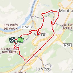
Trail Walking of 9.4 km to be discovered at Bourgogne-Franche-Comté, Doubs, Besançon. This trail is proposed by eltonnermou.
Description
Bâtons conseillés pour la descente sous le château. Tout type de sentier, sous bois et villages. de très beaux et nombreux points de vue sur vallée du Doubs, les monts du haut Doubs, les forts de Besançon.
Positioning
Country:
France
Region :
Bourgogne-Franche-Comté
Department/Province :
Doubs
Municipality :
Besançon
Location:
Unknown
Start:(Dec)
Start:(UTM)
276747 ; 5233823 (32T) N.
Comments
Trails nearby
![Trail Walking Beure - Beure de la pisseur au mercureau - Photo](https://media.geolcdn.com/t/375/260/af87c349-0861-4e70-9a13-b157a632bd51.jpg&format=jpg&maxdim=2)
![Walking Walking](https://static1.geolcdn.com/sitytour/trail-icons/101.png)
Beure de la pisseur au mercureau
Walking
Difficult
(1)
Beure,
Bourgogne-Franche-Comté,
Doubs,
France
![](/images/other/stat-length.png)
16.8 km | 24 km-effort
3h 48min
![](https://static1.geolcdn.com/siteimages/upload/files/16400158638029165_repeat_loop_refresh_sync_direction_icon.png)
Yes
![Trail Walking Beure -](https://media.geolcdn.com/t/375/260/1d465e36-f50c-4143-b089-4392e69daccf.jpg&format=jpg&maxdim=2)
![Walking Walking](https://static1.geolcdn.com/sitytour/trail-icons/101.png)
"De grottes en grottes par voies celtiques" Chabui Fontain
Walking
Medium
(1)
Beure,
Bourgogne-Franche-Comté,
Doubs,
France
![](/images/other/stat-length.png)
15.7 km | 22 km-effort
6h 35min
![](https://static1.geolcdn.com/siteimages/upload/files/16400158638029165_repeat_loop_refresh_sync_direction_icon.png)
Yes
![Trail Walking Beure - Beure, fort Planoise, Valmy, Roche trouée, vieille église. - Photo](https://media.geolcdn.com/t/375/260/f17b22e5-5227-4f08-8b37-03856be840af.jpg&format=jpg&maxdim=2)
![Walking Walking](https://static1.geolcdn.com/sitytour/trail-icons/101.png)
Beure, fort Planoise, Valmy, Roche trouée, vieille église.
Walking
Very difficult
(1)
Beure,
Bourgogne-Franche-Comté,
Doubs,
France
![](/images/other/stat-length.png)
12.9 km | 20 km-effort
4h 38min
![](https://static1.geolcdn.com/siteimages/upload/files/16400158638029165_repeat_loop_refresh_sync_direction_icon.png)
Yes
![Trail Walking Montfaucon - Du chateau au fort de Monfaucon - Photo](https://media.geolcdn.com/t/375/260/ext.jpg?maxdim=2&url=https%3A%2F%2Fservices.sitytrail.com%2FGeolivesWS%2FDownloadMedia.ashx%3FTrailID%3D705744%26Media%3Dfix__20170226154846.jpg)
![Walking Walking](https://static1.geolcdn.com/sitytour/trail-icons/101.png)
Du chateau au fort de Monfaucon
Walking
Easy
(1)
Montfaucon,
Bourgogne-Franche-Comté,
Doubs,
France
![](/images/other/stat-length.png)
6.9 km | 9.3 km-effort
1h 55min
![](https://static1.geolcdn.com/siteimages/upload/files/16400158638029165_repeat_loop_refresh_sync_direction_icon.png)
Yes
![Trail Walking Besançon - Colline de Besançon 29-08-2020 - Photo](https://media.geolcdn.com/t/375/260/1e155548-d400-46d3-8b28-207c9933a379.jpg&format=jpg&maxdim=2)
![Walking Walking](https://static1.geolcdn.com/sitytour/trail-icons/101.png)
Colline de Besançon 29-08-2020
Walking
Medium
(1)
Besançon,
Bourgogne-Franche-Comté,
Doubs,
France
![](/images/other/stat-length.png)
13.4 km | 17.7 km-effort
2h 46min
![](https://static1.geolcdn.com/siteimages/upload/files/16400158638029165_repeat_loop_refresh_sync_direction_icon.png)
Yes
![Trail Walking Fontain - fontain - fort de Fontain - forêt de Fontain - Photo](https://media.geolcdn.com/t/375/260/dda8671d-de1b-4872-afba-e5376a2d57f0.jpg&format=jpg&maxdim=2)
![Walking Walking](https://static1.geolcdn.com/sitytour/trail-icons/101.png)
fontain - fort de Fontain - forêt de Fontain
Walking
Very easy
(2)
Fontain,
Bourgogne-Franche-Comté,
Doubs,
France
![](/images/other/stat-length.png)
11.9 km | 15.2 km-effort
3h 11min
![](https://static1.geolcdn.com/siteimages/upload/files/16400158638029165_repeat_loop_refresh_sync_direction_icon.png)
Yes
![Trail On foot Montfaucon - Boucle de Nacra - Photo](https://media.geolcdn.com/t/375/260/754b99f9-55b9-4375-839c-408b044dfd0e.jpeg&format=jpg&maxdim=2)
![On foot On foot](https://static1.geolcdn.com/sitytour/trail-icons/100.png)
Boucle de Nacra
On foot
Easy
Montfaucon,
Bourgogne-Franche-Comté,
Doubs,
France
![](/images/other/stat-length.png)
3 km | 4.4 km-effort
1h 0min
![](https://static1.geolcdn.com/siteimages/upload/files/16400158638029165_repeat_loop_refresh_sync_direction_icon.png)
Yes
![Trail On foot Montfaucon - Sentier des Falaises et du château - Photo](https://media.geolcdn.com/t/375/260/5325d98d-322b-4b71-b21b-224d670c2150.jpeg&format=jpg&maxdim=2)
![On foot On foot](https://static1.geolcdn.com/sitytour/trail-icons/100.png)
Sentier des Falaises et du château
On foot
Easy
Montfaucon,
Bourgogne-Franche-Comté,
Doubs,
France
![](/images/other/stat-length.png)
5 km | 7.1 km-effort
1h 37min
![](https://static1.geolcdn.com/siteimages/upload/files/16400158638029165_repeat_loop_refresh_sync_direction_icon.png)
Yes
![Trail On foot Montfaucon - Sentier du Fort et des Batteries - Photo](https://media.geolcdn.com/t/375/260/465eae89-7ad3-4616-8710-419d54be2030.jpeg&format=jpg&maxdim=2)
![On foot On foot](https://static1.geolcdn.com/sitytour/trail-icons/100.png)
Sentier du Fort et des Batteries
On foot
Easy
Montfaucon,
Bourgogne-Franche-Comté,
Doubs,
France
![](/images/other/stat-length.png)
6.6 km | 8.7 km-effort
1h 58min
![](https://static1.geolcdn.com/siteimages/upload/files/16400158638029165_repeat_loop_refresh_sync_direction_icon.png)
Yes