![](/images/other/stat-length.png)
![Trail Walking Bullion - 20181201_Circuit_Bullion_Bonnelles_réalisé - Photo](https://media.geolcdn.com/t/1900/400/ext.pjpeg?maxdim=2&url=https%3A%2F%2Fstatic1.geolcdn.com%2Fsiteimages%2Fupload%2Ffiles%2F1553511878bg_sport_marche.png)
20181201_Circuit_Bullion_Bonnelles_réalisé
BMorin91470
User
![Length](/images/other/stat-length.png)
Length
8.3 km
![Max alt](https://static1.geolcdn.com/siteimages/upload/files/1508320355ic_sort_altitude_max_24dp.png)
Max alt
166 m
![Uphill gradient](https://static1.geolcdn.com/siteimages/upload/files/1508320355ic_sort_den_pos_24dp.png)
Uphill gradient
128 m
![Km-Effort](/images/other/stat-length.png)
Km-Effort
10 km
![Min alt](https://static1.geolcdn.com/siteimages/upload/files/1508320355ic_sort_altitude_min_24dp.png)
Min alt
108 m
![Downhill gradient](https://static1.geolcdn.com/siteimages/upload/files/1508320355ic_sort_den_neg_24dp.png)
Downhill gradient
124 m
![Boucle](https://static1.geolcdn.com/siteimages/upload/files/16400158638029165_repeat_loop_refresh_sync_direction_icon.png)
Boucle
Yes
Creation date :
2019-05-09 05:08:20.815
Updated on :
2022-11-13 08:03:55.051
![Walking](https://static1.geolcdn.com/sitytour/trail-icons/101.png)
2h21
Difficulty : Easy
![Scan this QR Code to open this trail in the SityTrail application](https://capi.geolives.com/qq0zvz2zws4bq2lad0pu/sitytour/trails/1079467/qr.png?size=200)
FREE GPS app for hiking
About
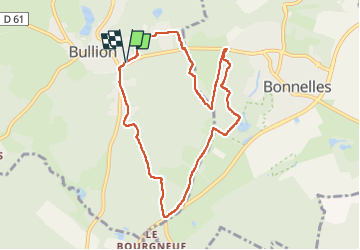
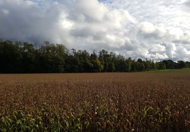
Trail Walking of 8.3 km to be discovered at Ile-de-France, Yvelines, Bullion. This trail is proposed by BMorin91470.
Description
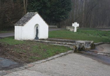
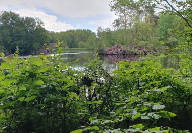
Circuit du Bois d'Haumont (répertorié n°3 dans le guide du PNR)avec un complément vers les étangs de Bonnelles.
Nota: difficulté à trouver la sortie du parc (grand mur) mal indiquée sur la carte IGN.
Positioning
Country:
France
Region :
Ile-de-France
Department/Province :
Yvelines
Municipality :
Bullion
Location:
Unknown
Start:(Dec)
Start:(UTM)
426334 ; 5385790 (31U) N.
Comments
Trails nearby
![Trail Walking La Celle-les-Bordes - _Sensations originelles - Photo](https://media.geolcdn.com/t/375/260/ext.jpg?maxdim=2&url=https%3A%2F%2Fservices.sitytrail.com%2FGeolivesWS%2FDownloadMedia.ashx%3FTrailID%3D172073%26Media%3D62ffcccf-49cf-426b-af31-a3cdff83876e.JPG)
![Walking Walking](https://static1.geolcdn.com/sitytour/trail-icons/101.png)
_Sensations originelles
Walking
Medium
(8)
La Celle-les-Bordes,
Ile-de-France,
Yvelines,
France
![](/images/other/stat-length.png)
13.6 km | 16 km-effort
3h 30min
![](https://static1.geolcdn.com/siteimages/upload/files/16400158638029165_repeat_loop_refresh_sync_direction_icon.png)
Yes
![Trail Walking Bonnelles - _Le rallye de Bonnelles à Rochefort - Photo](https://media.geolcdn.com/t/375/260/ext.jpg?maxdim=2&url=https%3A%2F%2Fservices.sitytrail.com%2FGeolivesWS%2FDownloadMedia.ashx%3FTrailID%3D172070%26Media%3De98fa123-dbbb-4948-ab08-19666b29bb58.jpg)
![Walking Walking](https://static1.geolcdn.com/sitytour/trail-icons/101.png)
_Le rallye de Bonnelles à Rochefort
Walking
Medium
(10)
Bonnelles,
Ile-de-France,
Yvelines,
France
![](/images/other/stat-length.png)
14.1 km | 16.4 km-effort
3h 30min
![](https://static1.geolcdn.com/siteimages/upload/files/16400158638029165_repeat_loop_refresh_sync_direction_icon.png)
Yes
![Trail Walking Longvilliers - _Les Moulins de la Rémarde - Photo](https://media.geolcdn.com/t/375/260/ext.jpg?maxdim=2&url=https%3A%2F%2Fservices.sitytrail.com%2FGeolivesWS%2FDownloadMedia.ashx%3FTrailID%3D172068%26Media%3Db1cdb090-96c0-44bf-89a1-996bab033954.jpg)
![Walking Walking](https://static1.geolcdn.com/sitytour/trail-icons/101.png)
_Les Moulins de la Rémarde
Walking
Easy
(8)
Longvilliers,
Ile-de-France,
Yvelines,
France
![](/images/other/stat-length.png)
9.3 km | 10.4 km-effort
2h 0min
![](https://static1.geolcdn.com/siteimages/upload/files/16400158638029165_repeat_loop_refresh_sync_direction_icon.png)
Yes
![Trail Walking Bullion - _Bullion, village vivant ! - Photo](https://media.geolcdn.com/t/375/260/ext.jpg?maxdim=2&url=https%3A%2F%2Fservices.sitytrail.com%2FGeolivesWS%2FDownloadMedia.ashx%3FTrailID%3D172071%26Media%3D4b3b53c0-a03c-424c-96bf-4753188fab20.jpg)
![Walking Walking](https://static1.geolcdn.com/sitytour/trail-icons/101.png)
_Bullion, village vivant !
Walking
Very easy
(5)
Bullion,
Ile-de-France,
Yvelines,
France
![](/images/other/stat-length.png)
7.1 km | 8.5 km-effort
1h 52min
![](https://static1.geolcdn.com/siteimages/upload/files/16400158638029165_repeat_loop_refresh_sync_direction_icon.png)
Yes
![Trail Walking Bullion - _Le bois d''Haumont - Photo](https://media.geolcdn.com/t/375/260/ext.jpg?maxdim=2&url=https%3A%2F%2Fservices.sitytrail.com%2FGeolivesWS%2FDownloadMedia.ashx%3FTrailID%3D172072%26Media%3D9dbe9f7c-fb0a-44be-ab73-8dc5727df278.JPG)
![Walking Walking](https://static1.geolcdn.com/sitytour/trail-icons/101.png)
_Le bois d''Haumont
Walking
Easy
(4)
Bullion,
Ile-de-France,
Yvelines,
France
![](/images/other/stat-length.png)
5.8 km | 7.1 km-effort
1h 30min
![](https://static1.geolcdn.com/siteimages/upload/files/16400158638029165_repeat_loop_refresh_sync_direction_icon.png)
Yes
![Trail Walking Pecqueuse - 20191019_Tour_des_Fermes_réalisé - Photo](https://media.geolcdn.com/t/375/260/3b6cb32e-1ca9-460c-8665-52898ea68512.jpg&format=jpg&maxdim=2)
![Walking Walking](https://static1.geolcdn.com/sitytour/trail-icons/101.png)
20191019_Tour_des_Fermes_réalisé
Walking
Very easy
(1)
Pecqueuse,
Ile-de-France,
Essonne,
France
![](/images/other/stat-length.png)
13.8 km | 15.2 km-effort
3h 43min
![](https://static1.geolcdn.com/siteimages/upload/files/16400158638029165_repeat_loop_refresh_sync_direction_icon.png)
Yes
![Trail Walking Bullion - Autour de Bullion - Photo](https://media.geolcdn.com/t/375/260/ext.jpg?maxdim=2&url=https%3A%2F%2Fservices.sitytrail.com%2FGeolivesWS%2FDownloadMedia.ashx%3FTrailID%3D102194%26Media%3D2593_2.jpg)
![Walking Walking](https://static1.geolcdn.com/sitytour/trail-icons/101.png)
Autour de Bullion
Walking
Difficult
(1)
Bullion,
Ile-de-France,
Yvelines,
France
![](/images/other/stat-length.png)
22 km | 26 km-effort
4h 30min
![](https://static1.geolcdn.com/siteimages/upload/files/16400158638029165_repeat_loop_refresh_sync_direction_icon.png)
Yes
![Trail Mountain bike Bonnelles - Bonnelle - Photo](https://media.geolcdn.com/t/375/260/ext.jpg?maxdim=2&url=https%3A%2F%2Fstatic1.geolcdn.com%2Fsiteimages%2Fupload%2Ffiles%2F1524743154velo.jpg)
![Mountain bike Mountain bike](https://static1.geolcdn.com/sitytour/trail-icons/202.png)
Bonnelle
Mountain bike
Easy
(1)
Bonnelles,
Ile-de-France,
Yvelines,
France
![](/images/other/stat-length.png)
52 km | 61 km-effort
Unknown
![](https://static1.geolcdn.com/siteimages/upload/files/16400158638029165_repeat_loop_refresh_sync_direction_icon.png)
Yes
![Trail Walking Bonnelles - Rumba à Bonnelles 2024 - Photo](https://media.geolcdn.com/t/375/260/7f613751-ef84-4e00-bd9f-0faeb5f1d9a9.jpg&format=jpg&maxdim=2)
![Walking Walking](https://static1.geolcdn.com/sitytour/trail-icons/101.png)
Rumba à Bonnelles 2024
Walking
Medium
Bonnelles,
Ile-de-France,
Yvelines,
France
![](/images/other/stat-length.png)
24 km | 28 km-effort
3h 6min
![](https://static1.geolcdn.com/siteimages/upload/files/16400158638029165_repeat_loop_refresh_sync_direction_icon.png)
No