![](/images/other/stat-length.png)
![Trail Walking Morre - Traîne bâton. Morre - Photo](https://media.geolcdn.com/t/1900/400/ext.pjpeg?maxdim=2&url=https%3A%2F%2Fstatic1.geolcdn.com%2Fsiteimages%2Fupload%2Ffiles%2F1553511878bg_sport_marche.png)
Traîne bâton. Morre
eltonnermou
User
![Length](/images/other/stat-length.png)
Length
7.6 km
![Max alt](https://static1.geolcdn.com/siteimages/upload/files/1508320355ic_sort_altitude_max_24dp.png)
Max alt
448 m
![Uphill gradient](https://static1.geolcdn.com/siteimages/upload/files/1508320355ic_sort_den_pos_24dp.png)
Uphill gradient
270 m
![Km-Effort](/images/other/stat-length.png)
Km-Effort
11.2 km
![Min alt](https://static1.geolcdn.com/siteimages/upload/files/1508320355ic_sort_altitude_min_24dp.png)
Min alt
238 m
![Downhill gradient](https://static1.geolcdn.com/siteimages/upload/files/1508320355ic_sort_den_neg_24dp.png)
Downhill gradient
272 m
![Boucle](https://static1.geolcdn.com/siteimages/upload/files/16400158638029165_repeat_loop_refresh_sync_direction_icon.png)
Boucle
Yes
Creation date :
2019-05-07 19:22:22.443
Updated on :
2019-05-07 19:22:22.443
![Walking](https://static1.geolcdn.com/sitytour/trail-icons/101.png)
1h15
Difficulty : Medium
![Scan this QR Code to open this trail in the SityTrail application](https://capi.geolives.com/qq0zvz2zws4bq2lad0pu/sitytour/trails/1078587/qr.png?size=200)
FREE GPS app for hiking
About
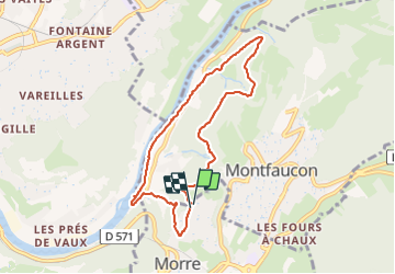
Trail Walking of 7.6 km to be discovered at Bourgogne-Franche-Comté, Doubs, Morre. This trail is proposed by eltonnermou.
Description
Descente sous le château : long passage difficile par SOL et temps mouillés, bâtons conseillées.Belles vues sur la vallée du Doubs, le château de Montfaucon. Belle randonnée essentiellement en sous bois
possibilité d'une connexion avec celle du trou au loup.
Positioning
Country:
France
Region :
Bourgogne-Franche-Comté
Department/Province :
Doubs
Municipality :
Morre
Location:
Unknown
Start:(Dec)
Start:(UTM)
278098 ; 5235046 (32T) N.
Comments
Trails nearby
![Trail Walking Beure - Beure de la pisseur au mercureau - Photo](https://media.geolcdn.com/t/375/260/ext.jpg?maxdim=2&url=https%3A%2F%2Fmedia.geolcdn.com%2Ff%2F9fe3b30a-2755-401a-b569-957806280789.jpg)
![Walking Walking](https://static1.geolcdn.com/sitytour/trail-icons/101.png)
Beure de la pisseur au mercureau
Walking
Difficult
(1)
Beure,
Bourgogne-Franche-Comté,
Doubs,
France
![](/images/other/stat-length.png)
16.8 km | 24 km-effort
3h 48min
![](https://static1.geolcdn.com/siteimages/upload/files/16400158638029165_repeat_loop_refresh_sync_direction_icon.png)
Yes
![Trail Walking Beure -](https://media.geolcdn.com/t/375/260/ext.jpg?maxdim=2&url=https%3A%2F%2Fmedia.geolcdn.com%2Ff%2F1d465e36-f50c-4143-b089-4392e69daccf.jpg)
![Walking Walking](https://static1.geolcdn.com/sitytour/trail-icons/101.png)
"De grottes en grottes par voies celtiques" Chabui Fontain
Walking
Medium
(1)
Beure,
Bourgogne-Franche-Comté,
Doubs,
France
![](/images/other/stat-length.png)
15.7 km | 22 km-effort
6h 35min
![](https://static1.geolcdn.com/siteimages/upload/files/16400158638029165_repeat_loop_refresh_sync_direction_icon.png)
Yes
![Trail Walking Montfaucon - Du chateau au fort de Monfaucon - Photo](https://media.geolcdn.com/t/375/260/ext.jpg?maxdim=2&url=https%3A%2F%2Fservices.sitytrail.com%2FGeolivesWS%2FDownloadMedia.ashx%3FTrailID%3D705744%26Media%3Dfix__20170226154846.jpg)
![Walking Walking](https://static1.geolcdn.com/sitytour/trail-icons/101.png)
Du chateau au fort de Monfaucon
Walking
Easy
(1)
Montfaucon,
Bourgogne-Franche-Comté,
Doubs,
France
![](/images/other/stat-length.png)
6.9 km | 9.3 km-effort
1h 55min
![](https://static1.geolcdn.com/siteimages/upload/files/16400158638029165_repeat_loop_refresh_sync_direction_icon.png)
Yes
![Trail Walking Besançon - Colline de Besançon 29-08-2020 - Photo](https://media.geolcdn.com/t/375/260/ext.jpg?maxdim=2&url=https%3A%2F%2Fmedia.geolcdn.com%2Ff%2F1e155548-d400-46d3-8b28-207c9933a379.jpg)
![Walking Walking](https://static1.geolcdn.com/sitytour/trail-icons/101.png)
Colline de Besançon 29-08-2020
Walking
Medium
(1)
Besançon,
Bourgogne-Franche-Comté,
Doubs,
France
![](/images/other/stat-length.png)
13.4 km | 17.7 km-effort
2h 46min
![](https://static1.geolcdn.com/siteimages/upload/files/16400158638029165_repeat_loop_refresh_sync_direction_icon.png)
Yes
![Trail Walking Fontain - fontain - fort de Fontain - forêt de Fontain - Photo](https://media.geolcdn.com/t/375/260/ext.jpg?maxdim=2&url=https%3A%2F%2Fmedia.geolcdn.com%2Ff%2Fb87cbef0-305c-4c42-8629-78124db9ab23.jpg)
![Walking Walking](https://static1.geolcdn.com/sitytour/trail-icons/101.png)
fontain - fort de Fontain - forêt de Fontain
Walking
Very easy
(1)
Fontain,
Bourgogne-Franche-Comté,
Doubs,
France
![](/images/other/stat-length.png)
10.9 km | 14 km-effort
3h 11min
![](https://static1.geolcdn.com/siteimages/upload/files/16400158638029165_repeat_loop_refresh_sync_direction_icon.png)
Yes
![Trail On foot Mamirolle - Sentier du Bois de la Fougère - Photo](https://media.geolcdn.com/t/375/260/ext.jpg?maxdim=2&url=https%3A%2F%2Fmedia.geolcdn.com%2Ff%2Fa8a8f146-f198-41be-852b-9ac1789ecd72.jpeg)
![On foot On foot](https://static1.geolcdn.com/sitytour/trail-icons/100.png)
Sentier du Bois de la Fougère
On foot
Easy
Mamirolle,
Bourgogne-Franche-Comté,
Doubs,
France
![](/images/other/stat-length.png)
7.3 km | 8.7 km-effort
1h 58min
![](https://static1.geolcdn.com/siteimages/upload/files/16400158638029165_repeat_loop_refresh_sync_direction_icon.png)
Yes
![Trail On foot Montfaucon - Boucle de Nacra - Photo](https://media.geolcdn.com/t/375/260/ext.jpg?maxdim=2&url=https%3A%2F%2Fmedia.geolcdn.com%2Ff%2F754b99f9-55b9-4375-839c-408b044dfd0e.jpeg)
![On foot On foot](https://static1.geolcdn.com/sitytour/trail-icons/100.png)
Boucle de Nacra
On foot
Easy
Montfaucon,
Bourgogne-Franche-Comté,
Doubs,
France
![](/images/other/stat-length.png)
3 km | 4.4 km-effort
1h 0min
![](https://static1.geolcdn.com/siteimages/upload/files/16400158638029165_repeat_loop_refresh_sync_direction_icon.png)
Yes
![Trail On foot Saône - Sentier des Essarts - Photo](https://media.geolcdn.com/t/375/260/ext.jpg?maxdim=2&url=https%3A%2F%2Fmedia.geolcdn.com%2Ff%2Fbda44002-ccb3-4d91-bd01-33fbc5477f0c.jpeg)
![On foot On foot](https://static1.geolcdn.com/sitytour/trail-icons/100.png)
Sentier des Essarts
On foot
Easy
Saône,
Bourgogne-Franche-Comté,
Doubs,
France
![](/images/other/stat-length.png)
6.9 km | 8.1 km-effort
1h 50min
![](https://static1.geolcdn.com/siteimages/upload/files/16400158638029165_repeat_loop_refresh_sync_direction_icon.png)
Yes
![Trail On foot Montfaucon - Sentier des Falaises et du château - Photo](https://media.geolcdn.com/t/375/260/ext.jpg?maxdim=2&url=https%3A%2F%2Fmedia.geolcdn.com%2Ff%2F5325d98d-322b-4b71-b21b-224d670c2150.jpeg)
![On foot On foot](https://static1.geolcdn.com/sitytour/trail-icons/100.png)
Sentier des Falaises et du château
On foot
Easy
Montfaucon,
Bourgogne-Franche-Comté,
Doubs,
France
![](/images/other/stat-length.png)
5 km | 7.1 km-effort
1h 37min
![](https://static1.geolcdn.com/siteimages/upload/files/16400158638029165_repeat_loop_refresh_sync_direction_icon.png)
Yes