Trail Walking La Chapelaude - Randonnée La Chapelaude - Photo
 tracegps
tracegps

User

© OpenStreetMap contributors
Length
Length
14.8 km
Max alt
Max alt
358 m
Uphill gradient
Uphill gradient
229 m
Km-Effort
Km-Effort  
17.9 km
Min alt
Min alt
232 m
Downhill gradient
Downhill gradient
231 m
Boucle
Boucle
Yes
Creation date :
2014-12-10 00:00:00.0
Updated on :
2014-12-10 00:00:00.0

(0 Reviews)

Walking
Walking
3h30
Difficulty : Medium

Scan this QR Code to open this trail in the SityTrail application

FREE GPS app for hiking

Logo SityTrail SityTrail

IGN / Geographical institutes

Download SityTrail from the App Store Download SityTrail from Google Play

Logo SityTrail SityTrail World

The world is yours!

Download SityTrail from the App Store Download SityTrail from Google Play Download SityTrail on Huawei AppGallery

About

Trail Walking of 14.8 km to be discovered at Auvergne-Rhône-Alpes, Allier, La Chapelaude. This trail is proposed by tracegps.

Description

Randonnée autour de la Meuzelle et du Ruisseau des Chiez.

Elevation profile

Photos

Positioning

Country:
France
Region :
Auvergne-Rhône-Alpes
Department/Province :
Allier
Municipality :
La Chapelaude
Location:
Unknown
Start:(UTM)
461759 ; 5141043 (31T) N.

Trails nearby

Trail Walking La Chapelaude - Circuit des côtes - La Chapelaude - Photo
Walking
tracegps

Walking

Difficult
La Chapelaude, Auvergne-Rhône-Alpes, Allier, France
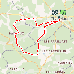
14.9 km | 17.8 km-effort
3h 45min
Yes
Trail Mountain bike Audes - Audes - Magnette - Photo
Mountain bike
Arnoldr8491

Mountain bike

Medium
Audes, Auvergne-Rhône-Alpes, Allier, France
15 km | 17.5 km-effort
1h 9min
Yes
Trail Hybrid bike La Chapelaude - 3eme jour road trip  - Photo
Hybrid bike
starsky03

Hybrid bike

Medium
La Chapelaude, Auvergne-Rhône-Alpes, Allier, France
25 km | 29 km-effort
9h 39min
No


Close
My subscriptions