![](/images/other/stat-length.png)
![Trail Running Noyers-sur-Jabron - Boucle Vieux Noyers - Chapelle St Claude - Photo](https://media.geolcdn.com/t/1900/400/ext.pjpeg?maxdim=2&url=https%3A%2F%2Fservices.sitytrail.com%2FGeolivesWS%2FDownloadMedia.ashx%3FTrailID%3D107724%26Media%3D12768_1.jpg)
Boucle Vieux Noyers - Chapelle St Claude
tracegps
User
![Length](/images/other/stat-length.png)
Length
9.3 km
![Max alt](https://static1.geolcdn.com/siteimages/upload/files/1508320355ic_sort_altitude_max_24dp.png)
Max alt
919 m
![Uphill gradient](https://static1.geolcdn.com/siteimages/upload/files/1508320355ic_sort_den_pos_24dp.png)
Uphill gradient
438 m
![Km-Effort](/images/other/stat-length.png)
Km-Effort
15.2 km
![Min alt](https://static1.geolcdn.com/siteimages/upload/files/1508320355ic_sort_altitude_min_24dp.png)
Min alt
563 m
![Downhill gradient](https://static1.geolcdn.com/siteimages/upload/files/1508320355ic_sort_den_neg_24dp.png)
Downhill gradient
434 m
![Boucle](https://static1.geolcdn.com/siteimages/upload/files/16400158638029165_repeat_loop_refresh_sync_direction_icon.png)
Boucle
Yes
Creation date :
2014-12-10 00:00:00.0
Updated on :
2014-12-10 00:00:00.0
![Running](https://static1.geolcdn.com/sitytour/trail-icons/103.png)
1h19
Difficulty : Medium
![Scan this QR Code to open this trail in the SityTrail application](https://capi.geolives.com/qq0zvz2zws4bq2lad0pu/sitytour/trails/107724/qr.png?size=200)
FREE GPS app for hiking
About
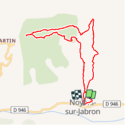
Trail Running of 9.3 km to be discovered at Provence-Alpes-Côte d'Azur, Alpes-de-Haute-Provence, Noyers-sur-Jabron. This trail is proposed by tracegps.
Description
Départ derrière la mairie. Prendre la route du Vieux Noyers jusqu'au croisement de Durban. Suivre Durban. Puis prendre le GR6 jusqu'au Vieux Noyers. Traverser le village. A la sortie prendre le sentier qui vous mènera jusqu'à la Chapelle St Claude.
Positioning
Country:
France
Region :
Provence-Alpes-Côte d'Azur
Department/Province :
Alpes-de-Haute-Provence
Municipality :
Noyers-sur-Jabron
Location:
Unknown
Start:(Dec)
Start:(UTM)
726174 ; 4894521 (31T) N.
Comments
Trails nearby
![Trail Walking Valbelle - VALBELLE . Chemin de Sara o l s - Photo](https://media.geolcdn.com/t/375/260/f5bc0f94-fea9-4cf8-899a-951c04f93f5f.jpg&format=jpg&maxdim=2)
![Walking Walking](https://static1.geolcdn.com/sitytour/trail-icons/101.png)
VALBELLE . Chemin de Sara o l s
Walking
Medium
(1)
Valbelle,
Provence-Alpes-Côte d'Azur,
Alpes-de-Haute-Provence,
France
![](/images/other/stat-length.png)
13.2 km | 19.7 km-effort
4h 47min
![](https://static1.geolcdn.com/siteimages/upload/files/16400158638029165_repeat_loop_refresh_sync_direction_icon.png)
Yes
![Trail Walking Valbelle - 05 chap st Pons col sumiou zel - Photo](https://media.geolcdn.com/t/375/260/654eadec-c68c-403c-8c9b-a622285d41ca.jpg&format=jpg&maxdim=2)
![Walking Walking](https://static1.geolcdn.com/sitytour/trail-icons/101.png)
05 chap st Pons col sumiou zel
Walking
Difficult
Valbelle,
Provence-Alpes-Côte d'Azur,
Alpes-de-Haute-Provence,
France
![](/images/other/stat-length.png)
11 km | 21 km-effort
5h 40min
![](https://static1.geolcdn.com/siteimages/upload/files/16400158638029165_repeat_loop_refresh_sync_direction_icon.png)
Yes
![Trail Walking Valbelle - chapelle saint Pont et montagne Sumiou - Photo](https://media.geolcdn.com/t/375/260/36d6cde7-c446-427e-9ab1-73d7e5890674.jpg&format=jpg&maxdim=2)
![Walking Walking](https://static1.geolcdn.com/sitytour/trail-icons/101.png)
chapelle saint Pont et montagne Sumiou
Walking
Difficult
Valbelle,
Provence-Alpes-Côte d'Azur,
Alpes-de-Haute-Provence,
France
![](/images/other/stat-length.png)
21 km | 34 km-effort
5h 11min
![](https://static1.geolcdn.com/siteimages/upload/files/16400158638029165_repeat_loop_refresh_sync_direction_icon.png)
Yes
![Trail On foot Noyers-sur-Jabron - Montagne de Sumiou - Grotte des Peyrouets_19_01_2024 - Photo](https://media.geolcdn.com/t/375/260/d885e4ac-abdf-4f73-b427-5e5b97ac821b.jpg&format=jpg&maxdim=2)
![On foot On foot](https://static1.geolcdn.com/sitytour/trail-icons/100.png)
Montagne de Sumiou - Grotte des Peyrouets_19_01_2024
On foot
Medium
Noyers-sur-Jabron,
Provence-Alpes-Côte d'Azur,
Alpes-de-Haute-Provence,
France
![](/images/other/stat-length.png)
16 km | 24 km-effort
5h 32min
![](https://static1.geolcdn.com/siteimages/upload/files/16400158638029165_repeat_loop_refresh_sync_direction_icon.png)
Yes
![Trail Walking Valbelle - 04 chapelle St Pons 03.08.23 - Photo](https://media.geolcdn.com/t/375/260/a22dc00e-ca36-48e1-a26c-c25718a9238f.jpg&format=jpg&maxdim=2)
![Walking Walking](https://static1.geolcdn.com/sitytour/trail-icons/101.png)
04 chapelle St Pons 03.08.23
Walking
Difficult
Valbelle,
Provence-Alpes-Côte d'Azur,
Alpes-de-Haute-Provence,
France
![](/images/other/stat-length.png)
8.2 km | 13.6 km-effort
3h 27min
![](https://static1.geolcdn.com/siteimages/upload/files/16400158638029165_repeat_loop_refresh_sync_direction_icon.png)
No
![Trail Walking Val-Buëch-Méouge - Rocher de pierre Impie, roc de l'aigle, pas de Berches - Photo](https://media.geolcdn.com/t/375/260/872433af-29da-42c0-940a-93266e0778d4.jpg&format=jpg&maxdim=2)
![Walking Walking](https://static1.geolcdn.com/sitytour/trail-icons/101.png)
Rocher de pierre Impie, roc de l'aigle, pas de Berches
Walking
Medium
Val-Buëch-Méouge,
Provence-Alpes-Côte d'Azur,
Hautes-Alpes,
France
![](/images/other/stat-length.png)
12.4 km | 23 km-effort
6h 1min
![](https://static1.geolcdn.com/siteimages/upload/files/16400158638029165_repeat_loop_refresh_sync_direction_icon.png)
No
![Trail Walking Noyers-sur-Jabron - SityTrail - NOYERS SUR JABRON , S Martin , col S Pierre , cretes de l ane n - Photo](https://media.geolcdn.com/t/375/260/b5b69900-a4cf-40a0-8395-e0fe0112d265.jpg&format=jpg&maxdim=2)
![Walking Walking](https://static1.geolcdn.com/sitytour/trail-icons/101.png)
SityTrail - NOYERS SUR JABRON , S Martin , col S Pierre , cretes de l ane n
Walking
Difficult
Noyers-sur-Jabron,
Provence-Alpes-Côte d'Azur,
Alpes-de-Haute-Provence,
France
![](/images/other/stat-length.png)
13.3 km | 24 km-effort
5h 28min
![](https://static1.geolcdn.com/siteimages/upload/files/16400158638029165_repeat_loop_refresh_sync_direction_icon.png)
Yes
![Trail On foot Valbelle - Montagne de Lure - Photo](https://media.geolcdn.com/t/375/260/d2f7e93b-ac8d-4890-bbc4-c62d8ad565bf.jpg&format=jpg&maxdim=2)
![On foot On foot](https://static1.geolcdn.com/sitytour/trail-icons/100.png)
Montagne de Lure
On foot
Difficult
Valbelle,
Provence-Alpes-Côte d'Azur,
Alpes-de-Haute-Provence,
France
![](/images/other/stat-length.png)
20 km | 35 km-effort
7h 54min
![](https://static1.geolcdn.com/siteimages/upload/files/16400158638029165_repeat_loop_refresh_sync_direction_icon.png)
Yes
![Trail Walking Valbelle - Tour de Sumiou - Photo](https://media.geolcdn.com/t/375/260/98046d43-9799-41dd-91ec-957f42022344.jpg&format=jpg&maxdim=2)
![Walking Walking](https://static1.geolcdn.com/sitytour/trail-icons/101.png)
Tour de Sumiou
Walking
Difficult
Valbelle,
Provence-Alpes-Côte d'Azur,
Alpes-de-Haute-Provence,
France
![](/images/other/stat-length.png)
13.4 km | 23 km-effort
5h 14min
![](https://static1.geolcdn.com/siteimages/upload/files/16400158638029165_repeat_loop_refresh_sync_direction_icon.png)
No