![](/images/other/stat-length.png)
![Trail Cycle Annecy - Cran Gevrier- Frangy - Cran par réseau secondaire - Photo](https://media.geolcdn.com/t/1900/400/ext.pjpeg?maxdim=2&url=https%3A%2F%2Fstatic1.geolcdn.com%2Fsiteimages%2Fupload%2Ffiles%2F1524743154velo.jpg)
Cran Gevrier- Frangy - Cran par réseau secondaire
tracegps
User
![Length](/images/other/stat-length.png)
Length
79 km
![Max alt](https://static1.geolcdn.com/siteimages/upload/files/1508320355ic_sort_altitude_max_24dp.png)
Max alt
656 m
![Uphill gradient](https://static1.geolcdn.com/siteimages/upload/files/1508320355ic_sort_den_pos_24dp.png)
Uphill gradient
1554 m
![Km-Effort](/images/other/stat-length.png)
Km-Effort
100 km
![Min alt](https://static1.geolcdn.com/siteimages/upload/files/1508320355ic_sort_altitude_min_24dp.png)
Min alt
312 m
![Downhill gradient](https://static1.geolcdn.com/siteimages/upload/files/1508320355ic_sort_den_neg_24dp.png)
Downhill gradient
1552 m
![Boucle](https://static1.geolcdn.com/siteimages/upload/files/16400158638029165_repeat_loop_refresh_sync_direction_icon.png)
Boucle
Yes
Creation date :
2014-12-10 00:00:00.0
Updated on :
2014-12-10 00:00:00.0
![Cycle](https://static1.geolcdn.com/sitytour/trail-icons/200.png)
3h00
Difficulty : Difficult
![Scan this QR Code to open this trail in the SityTrail application](https://capi.geolives.com/qq0zvz2zws4bq2lad0pu/sitytour/trails/107678/qr.png?size=200)
FREE GPS app for hiking
About
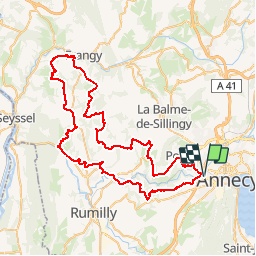
Trail Cycle of 79 km to be discovered at Auvergne-Rhône-Alpes, Upper Savoy, Annecy. This trail is proposed by tracegps.
Description
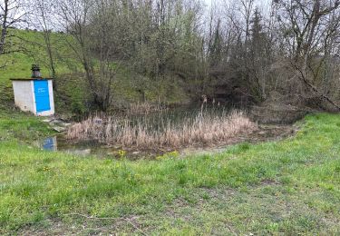
Circuit empruntant un maximum de petites routes, loin des grands axes de circulation. Nécessite environ 3h00 à 25 km/h. 1500 m de dénivelé environ.
Positioning
Country:
France
Region :
Auvergne-Rhône-Alpes
Department/Province :
Upper Savoy
Municipality :
Annecy
Location:
Cran-Gevrier
Start:(Dec)
Start:(UTM)
274779 ; 5087359 (32T) N.
Comments
Trails nearby
![Trail Walking Lovagny - 28/02/2022 - Gorges du Fier - Nonglard - Lovagny - Chavanod - Photo](https://media.geolcdn.com/t/375/260/ext.jpg?maxdim=2&url=https%3A%2F%2Fmedia.geolcdn.com%2Ff%2F03500606-e21f-4d38-a3f6-549dc5117f26.jpg)
![Walking Walking](https://static1.geolcdn.com/sitytour/trail-icons/101.png)
28/02/2022 - Gorges du Fier - Nonglard - Lovagny - Chavanod
Walking
Medium
Lovagny,
Auvergne-Rhône-Alpes,
Upper Savoy,
France
![](/images/other/stat-length.png)
20 km | 28 km-effort
5h 11min
![](https://static1.geolcdn.com/siteimages/upload/files/16400158638029165_repeat_loop_refresh_sync_direction_icon.png)
Yes
![Trail Cycle Annecy - semnoz par quintal - Photo](https://media.geolcdn.com/t/375/260/ext.jpg?maxdim=2&url=https%3A%2F%2Fstatic1.geolcdn.com%2Fsiteimages%2Fupload%2Ffiles%2F1524743154velo.jpg)
![Cycle Cycle](https://static1.geolcdn.com/sitytour/trail-icons/200.png)
semnoz par quintal
Cycle
Medium
(1)
Annecy,
Auvergne-Rhône-Alpes,
Upper Savoy,
France
![](/images/other/stat-length.png)
32 km | 52 km-effort
11min
![](https://static1.geolcdn.com/siteimages/upload/files/16400158638029165_repeat_loop_refresh_sync_direction_icon.png)
No
![Trail Mountain bike Annecy - semnoz 31 8 10 - Photo](https://media.geolcdn.com/t/375/260/ext.jpg?maxdim=2&url=https%3A%2F%2Fstatic1.geolcdn.com%2Fsiteimages%2Fupload%2Ffiles%2F1524743154velo.jpg)
![Mountain bike Mountain bike](https://static1.geolcdn.com/sitytour/trail-icons/202.png)
semnoz 31 8 10
Mountain bike
Very easy
(1)
Annecy,
Auvergne-Rhône-Alpes,
Upper Savoy,
France
![](/images/other/stat-length.png)
31 km | 48 km-effort
Unknown
![](https://static1.geolcdn.com/siteimages/upload/files/16400158638029165_repeat_loop_refresh_sync_direction_icon.png)
Yes
![Trail Walking Chavanod - CHAVANOD ... vers Montagny-les-Lanches. - Photo](https://media.geolcdn.com/t/375/260/ext.jpg?maxdim=2&url=https%3A%2F%2Fmedia.geolcdn.com%2Ff%2F9cf02be8-0d43-4c97-a143-e34f6de46c37.jpg)
![Walking Walking](https://static1.geolcdn.com/sitytour/trail-icons/101.png)
CHAVANOD ... vers Montagny-les-Lanches.
Walking
Easy
Chavanod,
Auvergne-Rhône-Alpes,
Upper Savoy,
France
![](/images/other/stat-length.png)
8.4 km | 10.7 km-effort
2h 5min
![](https://static1.geolcdn.com/siteimages/upload/files/16400158638029165_repeat_loop_refresh_sync_direction_icon.png)
Yes
![Trail Hybrid bike Annecy - ANNECY ... le Tour du lac à vélo. - Photo](https://media.geolcdn.com/t/375/260/ext.jpg?maxdim=2&url=https%3A%2F%2Fmedia.geolcdn.com%2Ff%2F64c38e9e-432d-4f1e-a098-d3a526529324.jpg)
![Hybrid bike Hybrid bike](https://static1.geolcdn.com/sitytour/trail-icons/203.png)
ANNECY ... le Tour du lac à vélo.
Hybrid bike
Easy
Annecy,
Auvergne-Rhône-Alpes,
Upper Savoy,
France
![](/images/other/stat-length.png)
38 km | 44 km-effort
1h 55min
![](https://static1.geolcdn.com/siteimages/upload/files/16400158638029165_repeat_loop_refresh_sync_direction_icon.png)
Yes
![Trail Walking Annecy - ANNECY ... le sentier des crêtes. - Photo](https://media.geolcdn.com/t/375/260/ext.jpg?maxdim=2&url=https%3A%2F%2Fmedia.geolcdn.com%2Ff%2F954e85ce-e790-4ec1-8a5b-52762288e410.jpg)
![Walking Walking](https://static1.geolcdn.com/sitytour/trail-icons/101.png)
ANNECY ... le sentier des crêtes.
Walking
Difficult
Annecy,
Auvergne-Rhône-Alpes,
Upper Savoy,
France
![](/images/other/stat-length.png)
10.6 km | 16.2 km-effort
3h 21min
![](https://static1.geolcdn.com/siteimages/upload/files/16400158638029165_repeat_loop_refresh_sync_direction_icon.png)
Yes
![Trail Walking Chavanod - CHAVANOD ... les Gorges du Fier. - Photo](https://media.geolcdn.com/t/375/260/ext.jpg?maxdim=2&url=https%3A%2F%2Fmedia.geolcdn.com%2Ff%2Fb76880dc-3a6b-4b5d-9dee-7a400ed01ca2.jpg)
![Walking Walking](https://static1.geolcdn.com/sitytour/trail-icons/101.png)
CHAVANOD ... les Gorges du Fier.
Walking
Medium
Chavanod,
Auvergne-Rhône-Alpes,
Upper Savoy,
France
![](/images/other/stat-length.png)
8 km | 10.8 km-effort
2h 20min
![](https://static1.geolcdn.com/siteimages/upload/files/16400158638029165_repeat_loop_refresh_sync_direction_icon.png)
Yes
![Trail Walking Annecy - 260523 Monr Veyrier - Photo](https://media.geolcdn.com/t/375/260/ext.jpg?maxdim=2&url=https%3A%2F%2Fmedia.geolcdn.com%2Ff%2F7cafe482-fdd0-430f-9583-efd1a36c0573.jpg)
![Walking Walking](https://static1.geolcdn.com/sitytour/trail-icons/101.png)
260523 Monr Veyrier
Walking
Difficult
Annecy,
Auvergne-Rhône-Alpes,
Upper Savoy,
France
![](/images/other/stat-length.png)
12.6 km | 25 km-effort
4h 24min
![](https://static1.geolcdn.com/siteimages/upload/files/16400158638029165_repeat_loop_refresh_sync_direction_icon.png)
Yes
![Trail sport Lovagny - 20230411 RANDONNÉE LOVAGNY - Photo](https://media.geolcdn.com/t/375/260/ext.jpg?maxdim=2&url=https%3A%2F%2Fmedia.geolcdn.com%2Ff%2Fdb936043-ccfb-4d87-a656-a3bf3f515ba1.jpg)
20230411 RANDONNÉE LOVAGNY
sport
Very easy
Lovagny,
Auvergne-Rhône-Alpes,
Upper Savoy,
France
![](/images/other/stat-length.png)
5 km | 7.5 km-effort
Unknown
![](https://static1.geolcdn.com/siteimages/upload/files/16400158638029165_repeat_loop_refresh_sync_direction_icon.png)
Yes