![](/images/other/stat-length.png)
![Trail Running Les Noës - Nouvelle Piste Forestière entre le Rocher de Rochefort et le Plan du Grand Jonc - Photo](https://media.geolcdn.com/t/1900/400/ext.pjpeg?maxdim=2&url=https%3A%2F%2Fservices.sitytrail.com%2FGeolivesWS%2FDownloadMedia.ashx%3FTrailID%3D107631%26Media%3D12614_6.jpg)
Nouvelle Piste Forestière entre le Rocher de Rochefort et le Plan du Grand Jonc
tracegps
User
![Length](/images/other/stat-length.png)
![Max alt](https://static1.geolcdn.com/siteimages/upload/files/1508320355ic_sort_altitude_max_24dp.png)
![Uphill gradient](https://static1.geolcdn.com/siteimages/upload/files/1508320355ic_sort_den_pos_24dp.png)
![Km-Effort](/images/other/stat-length.png)
![Min alt](https://static1.geolcdn.com/siteimages/upload/files/1508320355ic_sort_altitude_min_24dp.png)
![Downhill gradient](https://static1.geolcdn.com/siteimages/upload/files/1508320355ic_sort_den_neg_24dp.png)
![Boucle](https://static1.geolcdn.com/siteimages/upload/files/16400158638029165_repeat_loop_refresh_sync_direction_icon.png)
![Running](https://static1.geolcdn.com/sitytour/trail-icons/103.png)
2h00
Difficulty : Medium
![Scan this QR Code to open this trail in the SityTrail application](https://capi.geolives.com/qq0zvz2zws4bq2lad0pu/sitytour/trails/107631/qr.png?size=200)
FREE GPS app for hiking
About
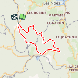
Trail Running of 12.8 km to be discovered at Auvergne-Rhône-Alpes, Loire, Les Noës. This trail is proposed by tracegps.
Description
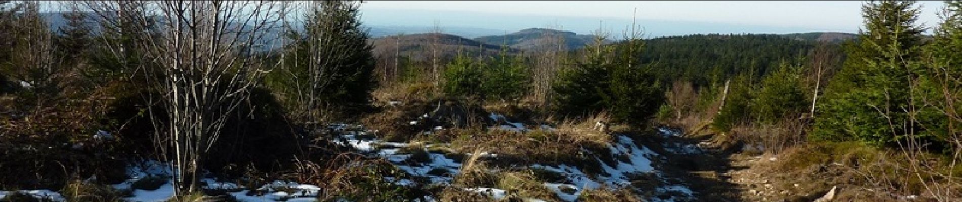
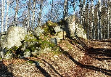
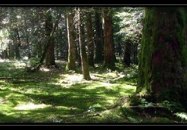
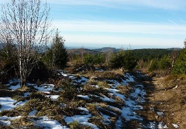
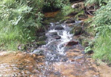
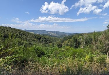
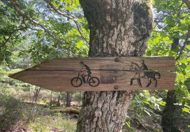
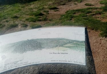
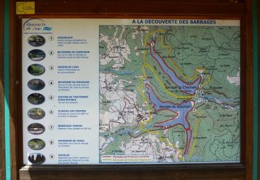
La nouvelle piste forestière créée sur une longueur de 4,9 km, depuis le "Rocher de Rochefort" jusqu'au "Plan du Grand Jonc", permet de relier Arcon aux Noës, en passant par la Croix Trévingt. Après le carrefour du "Plan de Grand Jonc", une autre piste a été restaurée pour déboucher sur la route D 47 au niveau de La Goutte Bruyère, en amont du lieu dit La Croze ou La sable. Ce nouveau passage ondule et serpente à flanc de montagne tout en traversant les bois. Sur les versants coulent de nombreuses sources qui forment des petits ruisseaux que l'on entend chanter en dévalant les pentes prononcées pour rejoindre la vallée du Rouchain afin de gonfler le ruisseau du même nom. Parking et départ du lieu dit de la "Grande Borne" à 1029 m d'altitude (limite entre les départements de La Loire et de l'Allier). La "Grande Borne" se situe sur l'axe (D 47 – D 478) Renaison, Les Noës et La Loge des Gardes (Base de loisir en été et station de ski en hiver). Cette balade facile et agréable vous fera marcher en moyenne montagne sur des pistes et des sentiers majoritairement dans la forêt où l’eau ruisselle d’un peu partout et vous vous déplacerez toujours entre 900 et 1100 m d'altitude. Du parking dès que le sentier pierreux s’élève jeter régulièrement un coup d’œil sur votre droite (vers l’ouest) et vous apercevrez certainement le Puy de Dôme. Sur le plateau du "Gué de la Chaux" un bref passage à découvert avec un joli coup d'œil sur le plan d'eau artificiel puis en remontant en direction du Rocher de Rochefort il est possible d'apercevoir le Mont Blanc par temps clair (vers l’est). En descendant vers le nouveau chemin forestier, vous pourrez admirer par quelques trouées, la vallée du Rouchain et la plaine Roannaise. Plus loin vers l’horizon se dessinent les Monts du Beaujolais. Avec une bonne couche de neige, il serait fort agréable de faire ce parcours en raquettes... Topoguide : Randonnée en Côte Roannaise (30 circuits de randonnée pédestre, équestre et VTT), disponible à l'O.T de Roanne.
Positioning
Comments
Trails nearby
![Trail Walking Saint-Nicolas-des-Biefs - Ronde boisée des rochers et des ruisseaux - La Verrerie - Photo](https://media.geolcdn.com/t/375/260/ext.jpg?maxdim=2&url=https%3A%2F%2Fservices.sitytrail.com%2FGeolivesWS%2FDownloadMedia.ashx%3FTrailID%3D317633%26Media%3D16900_4.jpg)
![Walking Walking](https://static1.geolcdn.com/sitytour/trail-icons/101.png)
Walking
![](/images/other/stat-length.png)
![](https://static1.geolcdn.com/siteimages/upload/files/16400158638029165_repeat_loop_refresh_sync_direction_icon.png)
![Trail Walking Les Noës - Les Grands Joncs - Les Noës - Photo](https://media.geolcdn.com/t/375/260/ext.jpg?maxdim=2&url=https%3A%2F%2Fservices.sitytrail.com%2FGeolivesWS%2FDownloadMedia.ashx%3FTrailID%3D173243%26Media%3D14853_3.jpg)
![Walking Walking](https://static1.geolcdn.com/sitytour/trail-icons/101.png)
Walking
![](/images/other/stat-length.png)
![](https://static1.geolcdn.com/siteimages/upload/files/16400158638029165_repeat_loop_refresh_sync_direction_icon.png)
![Trail Walking Les Noës - Nouvelle Piste Forestière entre le Rocher de Rochefort et le Plan du Grand Jonc - Photo](https://media.geolcdn.com/t/375/260/ext.jpg?maxdim=2&url=https%3A%2F%2Fservices.sitytrail.com%2FGeolivesWS%2FDownloadMedia.ashx%3FTrailID%3D107630%26Media%3D12614_6.jpg)
![Walking Walking](https://static1.geolcdn.com/sitytour/trail-icons/101.png)
Walking
![](/images/other/stat-length.png)
![](https://static1.geolcdn.com/siteimages/upload/files/16400158638029165_repeat_loop_refresh_sync_direction_icon.png)
![Trail Walking Saint-Nicolas-des-Biefs - St Nicolas- circuit du Barbenan - Photo](https://media.geolcdn.com/t/375/260/ext.jpg?maxdim=2&url=https%3A%2F%2Fservices.sitytrail.com%2FGeolivesWS%2FDownloadMedia.ashx%3FTrailID%3D606892%26Media%3Dfix__20160731170655.jpg)
![Walking Walking](https://static1.geolcdn.com/sitytour/trail-icons/101.png)
Walking
![](/images/other/stat-length.png)
![](https://static1.geolcdn.com/siteimages/upload/files/16400158638029165_repeat_loop_refresh_sync_direction_icon.png)
![Trail Walking La Chabanne - périasse boucle 7 km - Photo](https://media.geolcdn.com/t/375/260/ext.jpg?maxdim=2&url=https%3A%2F%2Fmedia.geolcdn.com%2Ff%2F3ea506f1-1a6e-4f9b-a809-3df88ca4c02b.jpg)
![Walking Walking](https://static1.geolcdn.com/sitytour/trail-icons/101.png)
Walking
![](/images/other/stat-length.png)
![](https://static1.geolcdn.com/siteimages/upload/files/16400158638029165_repeat_loop_refresh_sync_direction_icon.png)
![Trail Walking Renaison - Renaison : d’un barrage à l’autre - Photo](https://media.geolcdn.com/t/375/260/ext.jpg?maxdim=2&url=https%3A%2F%2Fmedia.geolcdn.com%2Ff%2F0c55d59a-831c-4f21-8687-c1695b3393b5.jpg)
![Walking Walking](https://static1.geolcdn.com/sitytour/trail-icons/101.png)
Walking
![](/images/other/stat-length.png)
![](https://static1.geolcdn.com/siteimages/upload/files/16400158638029165_repeat_loop_refresh_sync_direction_icon.png)
![Trail Walking Saint-Nicolas-des-Biefs - rando du roc du Vacher à St Nicolas des Biefs - Photo](https://media.geolcdn.com/t/375/260/ext.jpg?maxdim=2&url=https%3A%2F%2Fmedia.geolcdn.com%2Ff%2F3714a1ed-498c-4402-9263-e78aee47b4a3.jpg)
![Walking Walking](https://static1.geolcdn.com/sitytour/trail-icons/101.png)
Walking
![](/images/other/stat-length.png)
![](https://static1.geolcdn.com/siteimages/upload/files/16400158638029165_repeat_loop_refresh_sync_direction_icon.png)
![Trail Snowshoes Les Noës - la loge aux gardes - Photo](https://media.geolcdn.com/t/375/260/ext.jpg?maxdim=2&url=https%3A%2F%2Fservices.sitytrail.com%2FGeolivesWS%2FDownloadMedia.ashx%3FTrailID%3D390981%26Media%3Dfix__20150228150811.jpg)
![Snowshoes Snowshoes](https://static1.geolcdn.com/sitytour/trail-icons/504.png)
Snowshoes
![](/images/other/stat-length.png)
![](https://static1.geolcdn.com/siteimages/upload/files/16400158638029165_repeat_loop_refresh_sync_direction_icon.png)
![Trail Mountain bike Renaison - Boucle autour de la Faille du Rouchain - Renaison (les barrages) - Photo](https://media.geolcdn.com/t/375/260/ext.jpg?maxdim=2&url=https%3A%2F%2Fservices.sitytrail.com%2FGeolivesWS%2FDownloadMedia.ashx%3FTrailID%3D318016%26Media%3D17472_6.jpg)
![Mountain bike Mountain bike](https://static1.geolcdn.com/sitytour/trail-icons/202.png)
Mountain bike
![](/images/other/stat-length.png)
![](https://static1.geolcdn.com/siteimages/upload/files/16400158638029165_repeat_loop_refresh_sync_direction_icon.png)