![](/images/other/stat-length.png)
![Trail Walking Pourcieux - Le Mont Aurélien, une traversée - Pourcieux - Photo](https://media.geolcdn.com/t/1900/400/ext.pjpeg?maxdim=2&url=https%3A%2F%2Fservices.sitytrail.com%2FGeolivesWS%2FDownloadMedia.ashx%3FTrailID%3D107615%26Media%3D12587_1.jpg)
Le Mont Aurélien, une traversée - Pourcieux
tracegps
User
![Length](/images/other/stat-length.png)
![Max alt](https://static1.geolcdn.com/siteimages/upload/files/1508320355ic_sort_altitude_max_24dp.png)
![Uphill gradient](https://static1.geolcdn.com/siteimages/upload/files/1508320355ic_sort_den_pos_24dp.png)
![Km-Effort](/images/other/stat-length.png)
![Min alt](https://static1.geolcdn.com/siteimages/upload/files/1508320355ic_sort_altitude_min_24dp.png)
![Downhill gradient](https://static1.geolcdn.com/siteimages/upload/files/1508320355ic_sort_den_neg_24dp.png)
![Boucle](https://static1.geolcdn.com/siteimages/upload/files/16400158638029165_repeat_loop_refresh_sync_direction_icon.png)
![Walking](https://static1.geolcdn.com/sitytour/trail-icons/101.png)
6h00
Difficulty : Easy
![Scan this QR Code to open this trail in the SityTrail application](https://capi.geolives.com/qq0zvz2zws4bq2lad0pu/sitytour/trails/107615/qr.png?size=200)
FREE GPS app for hiking
About
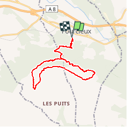
Trail Walking of 16.7 km to be discovered at Provence-Alpes-Côte d'Azur, Var, Pourcieux. This trail is proposed by tracegps.
Description
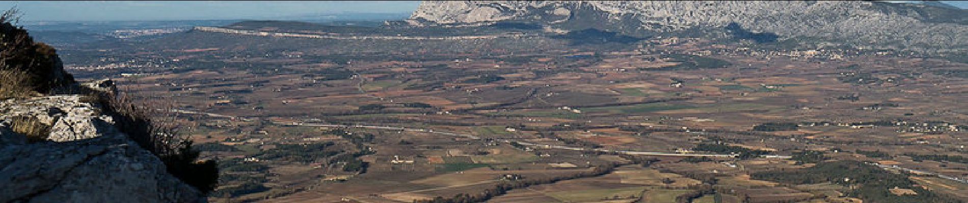
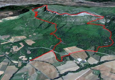
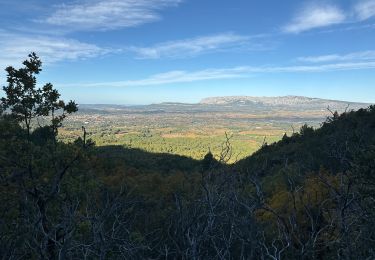
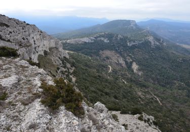
Pays d'Aix-en-Provence. Dominant Pourcieux, le Mont Aurélien étire sa longue barre rocheuse d'Est en Ouest. Depuis l'aire de pique nique, au Sud de Pourcieux accessible par la Nationale 7, la longue randonnée parcourt le bois du Défens pour atteindre le Chemin des Contrebandiers. Passant à proximité, on ne manquera pas la visite des ruines du Château de Saint-Barthélémy avant de poursuivre la longue piste jusqu'au Col du Rocher de l'Olympe. Au col, commence le parcours de la crête du Mont Aurélien, centre d'intérêt de la randonnée qui va traverser l'Olympe et le Pas de Titet pour atteindre le sommet du mont, point coté 876m. L'itinéraire traverse le Pas de la Croix, le Pas des Ifs avant de plonger dans les pentes raides qui dominent l'héliport DFCI. Le retour par le Chemin des Contrebandiers, permet de retrouver l'itinéraire d'ascension et le point de départ. Description complète sur sentier-nature.com : Le Mont Aurélien, une traversée Avertissement [Pénibilité 2/3].Certains passages de cet itinéraire de montagne sont escarpés et/ou très exposés, il est déconseillé aux enfants non accompagnés et aux personnes sujettes au vertige. Pour votre sécurité, nous vous invitons à respecter les règles suivantes : être bien chaussé, ne pas s'engager par mauvais temps, ne pas s'écarter de l'itinéraire ni des sentiers.
Positioning
Comments
Trails nearby
![Trail Walking Pourrières - JPS Monts Aurélien-17655561 - Photo](https://media.geolcdn.com/t/375/260/8dbb5ea6-c181-4e2b-88a9-6319fd5fd375.jpg&format=jpg&maxdim=2)
![Walking Walking](https://static1.geolcdn.com/sitytour/trail-icons/101.png)
Walking
![](/images/other/stat-length.png)
![](https://static1.geolcdn.com/siteimages/upload/files/16400158638029165_repeat_loop_refresh_sync_direction_icon.png)
![Trail Walking Pourcieux - 2022-11-11_17h53m46_pourcieux - Photo](https://media.geolcdn.com/t/375/260/ext.jpg?maxdim=2&url=https%3A%2F%2Fstatic1.geolcdn.com%2Fsiteimages%2Fupload%2Ffiles%2F1553511878bg_sport_marche.png)
![Walking Walking](https://static1.geolcdn.com/sitytour/trail-icons/101.png)
Walking
![](/images/other/stat-length.png)
![](https://static1.geolcdn.com/siteimages/upload/files/16400158638029165_repeat_loop_refresh_sync_direction_icon.png)
![Trail Walking Pourcieux - pas des iifs - Photo](https://media.geolcdn.com/t/375/260/ext.jpg?maxdim=2&url=https%3A%2F%2Fstatic1.geolcdn.com%2Fsiteimages%2Fupload%2Ffiles%2F1553511878bg_sport_marche.png)
![Walking Walking](https://static1.geolcdn.com/sitytour/trail-icons/101.png)
Walking
![](/images/other/stat-length.png)
![](https://static1.geolcdn.com/siteimages/upload/files/16400158638029165_repeat_loop_refresh_sync_direction_icon.png)
![Trail Walking Pourrières - Mt Olympe et le pas du Titet - Photo](https://media.geolcdn.com/t/375/260/dc918a12-1c27-4a5f-a427-bc8e0fdbc469.jpg&format=jpg&maxdim=2)
![Walking Walking](https://static1.geolcdn.com/sitytour/trail-icons/101.png)
Walking
![](/images/other/stat-length.png)
![](https://static1.geolcdn.com/siteimages/upload/files/16400158638029165_repeat_loop_refresh_sync_direction_icon.png)
![Trail Walking Pourcieux - 2024-03-02_17h01m33_La chouette d'Or Pourcieux - Photo](https://media.geolcdn.com/t/375/260/ext.jpg?maxdim=2&url=https%3A%2F%2Fstatic1.geolcdn.com%2Fsiteimages%2Fupload%2Ffiles%2F1553511878bg_sport_marche.png)
![Walking Walking](https://static1.geolcdn.com/sitytour/trail-icons/101.png)
Walking
![](/images/other/stat-length.png)
![](https://static1.geolcdn.com/siteimages/upload/files/16400158638029165_repeat_loop_refresh_sync_direction_icon.png)
![Trail Walking Trets - SityTrail - mont olympe + crête - Photo](https://media.geolcdn.com/t/375/260/ext.jpg?maxdim=2&url=https%3A%2F%2Fstatic1.geolcdn.com%2Fsiteimages%2Fupload%2Ffiles%2F1553511878bg_sport_marche.png)
![Walking Walking](https://static1.geolcdn.com/sitytour/trail-icons/101.png)
Walking
![](/images/other/stat-length.png)
![](https://static1.geolcdn.com/siteimages/upload/files/16400158638029165_repeat_loop_refresh_sync_direction_icon.png)
![Trail Walking Pourrières - Pourcieux :Mont Olympe et Pas du Titet - Photo](https://media.geolcdn.com/t/375/260/bc3de33d-3e9b-495a-a14b-a8c68a4f3699.jpg&format=jpg&maxdim=2)
![Walking Walking](https://static1.geolcdn.com/sitytour/trail-icons/101.png)
Walking
![](/images/other/stat-length.png)
![](https://static1.geolcdn.com/siteimages/upload/files/16400158638029165_repeat_loop_refresh_sync_direction_icon.png)
![Walking Walking](https://static1.geolcdn.com/sitytour/trail-icons/101.png)
Walking
![](/images/other/stat-length.png)
![](https://static1.geolcdn.com/siteimages/upload/files/16400158638029165_repeat_loop_refresh_sync_direction_icon.png)
![Trail Walking Pourcieux - Croix de pourcieux - Photo](https://media.geolcdn.com/t/375/260/028bd40e-26d3-4985-87d9-e7ed90ef1201.jpg&format=jpg&maxdim=2)
![Walking Walking](https://static1.geolcdn.com/sitytour/trail-icons/101.png)
Walking
![](/images/other/stat-length.png)
![](https://static1.geolcdn.com/siteimages/upload/files/16400158638029165_repeat_loop_refresh_sync_direction_icon.png)