![](/images/other/stat-length.png)
![Trail Walking Vizille - Sur les Pas des Huguenots - Vizille - Echirolles - Photo](https://media.geolcdn.com/t/1900/400/ext.pjpeg?maxdim=2&url=https%3A%2F%2Fservices.sitytrail.com%2FGeolivesWS%2FDownloadMedia.ashx%3FTrailID%3D107611%26Media%3D12582_6.jpg)
Sur les Pas des Huguenots - Vizille - Echirolles
tracegps
User
![Length](/images/other/stat-length.png)
![Max alt](https://static1.geolcdn.com/siteimages/upload/files/1508320355ic_sort_altitude_max_24dp.png)
![Uphill gradient](https://static1.geolcdn.com/siteimages/upload/files/1508320355ic_sort_den_pos_24dp.png)
![Km-Effort](/images/other/stat-length.png)
![Min alt](https://static1.geolcdn.com/siteimages/upload/files/1508320355ic_sort_altitude_min_24dp.png)
![Downhill gradient](https://static1.geolcdn.com/siteimages/upload/files/1508320355ic_sort_den_neg_24dp.png)
![Boucle](https://static1.geolcdn.com/siteimages/upload/files/16400158638029165_repeat_loop_refresh_sync_direction_icon.png)
![Walking](https://static1.geolcdn.com/sitytour/trail-icons/101.png)
4h00
Difficulty : Difficult
![Scan this QR Code to open this trail in the SityTrail application](https://capi.geolives.com/qq0zvz2zws4bq2lad0pu/sitytour/trails/107611/qr.png?size=200)
FREE GPS app for hiking
About
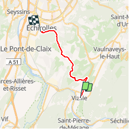
Trail Walking of 12.4 km to be discovered at Auvergne-Rhône-Alpes, Isère, Vizille. This trail is proposed by tracegps.
Description
« Sur les pas des Huguenots » consiste en la création d'un sentier international de grande randonnée suivant le tracé historique de l'exil des Huguenots dauphinois vers l'Allemagne et la Suisse après la révocation de l’Édit de Nantes (1685-1690), ainsi que la création de deux itinéraires de l'Italie vers la Suisse, l'exode et la Glorieuse Rentrée des Vaudois du Piémont.
Positioning
Comments
Trails nearby
![Trail Running Vizille - Echappée Belle 2013 - Photo](https://media.geolcdn.com/t/375/260/ext.jpg?maxdim=2&url=https%3A%2F%2Fstatic1.geolcdn.com%2Fsiteimages%2Fupload%2Ffiles%2F1524743154running.jpg)
![Running Running](https://static1.geolcdn.com/sitytour/trail-icons/103.png)
Running
![](/images/other/stat-length.png)
![](https://static1.geolcdn.com/siteimages/upload/files/16400158638029165_repeat_loop_refresh_sync_direction_icon.png)
![Trail Walking Champ-sur-Drac - 38 Couvent St Michel Champ / drac - Photo](https://media.geolcdn.com/t/375/260/2541c209-e2b9-4fc5-ac0c-29659bf67ee5.jpg&format=jpg&maxdim=2)
![Walking Walking](https://static1.geolcdn.com/sitytour/trail-icons/101.png)
Walking
![](/images/other/stat-length.png)
![](https://static1.geolcdn.com/siteimages/upload/files/16400158638029165_repeat_loop_refresh_sync_direction_icon.png)
![Trail Nordic walking Jarrie - Mon chabou -haut jarret - Photo](https://media.geolcdn.com/t/375/260/8d9b08e7-4849-40d2-bae6-1be2c82dc5a3.jpg&format=jpg&maxdim=2)
![Nordic walking Nordic walking](https://static1.geolcdn.com/sitytour/trail-icons/102.png)
Nordic walking
![](/images/other/stat-length.png)
![](https://static1.geolcdn.com/siteimages/upload/files/16400158638029165_repeat_loop_refresh_sync_direction_icon.png)
![Trail Walking Brié-et-Angonnes - Brié - Montchabout - Sommet de Pravena - Photo](https://media.geolcdn.com/t/375/260/0f2df736-86ba-41cf-8335-b76275aca73b.jpg&format=jpg&maxdim=2)
![Walking Walking](https://static1.geolcdn.com/sitytour/trail-icons/101.png)
Walking
![](/images/other/stat-length.png)
![](https://static1.geolcdn.com/siteimages/upload/files/16400158638029165_repeat_loop_refresh_sync_direction_icon.png)
![Trail Walking Vaulnaveys-le-Bas - Montchaffrey/chartreuse de premol - Photo](https://media.geolcdn.com/t/375/260/bb0c8a32-d481-4cd5-bf35-438acdb94f2e.jpg&format=jpg&maxdim=2)
![Walking Walking](https://static1.geolcdn.com/sitytour/trail-icons/101.png)
Walking
![](/images/other/stat-length.png)
![](https://static1.geolcdn.com/siteimages/upload/files/16400158638029165_repeat_loop_refresh_sync_direction_icon.png)
![Trail Walking Brié-et-Angonnes - Brié- Table d'orientation - Photo](https://media.geolcdn.com/t/375/260/7bbbe70d-bffa-4966-9f56-9fa776cf97b0.jpg&format=jpg&maxdim=2)
![Walking Walking](https://static1.geolcdn.com/sitytour/trail-icons/101.png)
Walking
![](/images/other/stat-length.png)
![](https://static1.geolcdn.com/siteimages/upload/files/16400158638029165_repeat_loop_refresh_sync_direction_icon.png)
![Trail Nordic walking Jarrie - Château de Bon Repos, Bois de Bouchassey, Saut du Moine - Photo](https://media.geolcdn.com/t/375/260/6035c0cd-abfc-41ef-b589-8891c45ae620.jpg&format=jpg&maxdim=2)
![Nordic walking Nordic walking](https://static1.geolcdn.com/sitytour/trail-icons/102.png)
Nordic walking
![](/images/other/stat-length.png)
![](https://static1.geolcdn.com/siteimages/upload/files/16400158638029165_repeat_loop_refresh_sync_direction_icon.png)
![Trail Walking Séchilienne - Col De La Madeleine en circuit par les Pavies de Sėchilienne - Photo](https://media.geolcdn.com/t/375/260/2e8c4d28-aa51-4ff7-afca-94e141b05ff2.jpg&format=jpg&maxdim=2)
![Walking Walking](https://static1.geolcdn.com/sitytour/trail-icons/101.png)
Walking
![](/images/other/stat-length.png)
![](https://static1.geolcdn.com/siteimages/upload/files/16400158638029165_repeat_loop_refresh_sync_direction_icon.png)
![Trail Nordic walking Vizille - Circuit en MN dans le parc de Vizille - Photo](https://media.geolcdn.com/t/375/260/51f9bff4-5f52-4fb6-a1e9-0e5556296f34.jpg&format=jpg&maxdim=2)
![Nordic walking Nordic walking](https://static1.geolcdn.com/sitytour/trail-icons/102.png)
Nordic walking
![](/images/other/stat-length.png)
![](https://static1.geolcdn.com/siteimages/upload/files/16400158638029165_repeat_loop_refresh_sync_direction_icon.png)