![](/images/other/stat-length.png)
![Trail Mountain bike Cornillon-Confoux - S'amuser à Cornillon-Confoux - Photo](https://media.geolcdn.com/t/1900/400/ext.pjpeg?maxdim=2&url=https%3A%2F%2Fservices.sitytrail.com%2FGeolivesWS%2FDownloadMedia.ashx%3FTrailID%3D107606%26Media%3D12571_2.jpg)
S'amuser à Cornillon-Confoux
tracegps
User
![Length](/images/other/stat-length.png)
![Max alt](https://static1.geolcdn.com/siteimages/upload/files/1508320355ic_sort_altitude_max_24dp.png)
![Uphill gradient](https://static1.geolcdn.com/siteimages/upload/files/1508320355ic_sort_den_pos_24dp.png)
![Km-Effort](/images/other/stat-length.png)
![Min alt](https://static1.geolcdn.com/siteimages/upload/files/1508320355ic_sort_altitude_min_24dp.png)
![Downhill gradient](https://static1.geolcdn.com/siteimages/upload/files/1508320355ic_sort_den_neg_24dp.png)
![Boucle](https://static1.geolcdn.com/siteimages/upload/files/16400158638029165_repeat_loop_refresh_sync_direction_icon.png)
![Mountain bike](https://static1.geolcdn.com/sitytour/trail-icons/202.png)
1h00
Difficulty : Difficult
![Scan this QR Code to open this trail in the SityTrail application](https://capi.geolives.com/qq0zvz2zws4bq2lad0pu/sitytour/trails/107606/qr.png?size=200)
FREE GPS app for hiking
About
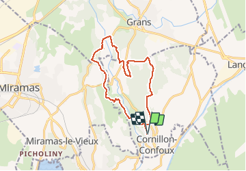
Trail Mountain bike of 13.8 km to be discovered at Provence-Alpes-Côte d'Azur, Bouches-du-Rhône, Cornillon-Confoux. This trail is proposed by tracegps.
Description
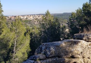
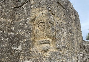
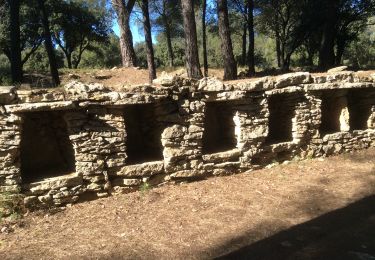
Petite balade sympa avec 2 descentes techniques. Tout d'abord on emprunte une promenade "Circuit des Borries", partie roulante. Ensuite on quitte le parcours pour emprunter un petit sentier qui passe dans les arbres avec une superbe vue, attention à ne pas tomber de la falaise... Ensuite un peu de route pour repartir sur le domaine de Lunar où plusieurs chemins se présentent à vous. Ensuite on emprunte un autre petit sentier où se trouve une descente technique. On arrive au point minimal d'altitude et donc il faut tout remonter... Tout ce parcours se situe dans un cadre magnifique.
Positioning
Comments
Trails nearby
![Trail Walking Miramas - Miramas le vieux- tour de guet - Photo](https://media.geolcdn.com/t/375/260/bceb2c2b-a11e-4eeb-8b54-cb95c623a8a6.jpg&format=jpg&maxdim=2)
![Walking Walking](https://static1.geolcdn.com/sitytour/trail-icons/101.png)
Walking
![](/images/other/stat-length.png)
![](https://static1.geolcdn.com/siteimages/upload/files/16400158638029165_repeat_loop_refresh_sync_direction_icon.png)
![Walking Walking](https://static1.geolcdn.com/sitytour/trail-icons/101.png)
Walking
![](/images/other/stat-length.png)
![](https://static1.geolcdn.com/siteimages/upload/files/16400158638029165_repeat_loop_refresh_sync_direction_icon.png)
![Trail Walking Miramas - Belval-Pont de Rhaud - Photo](https://media.geolcdn.com/t/375/260/b4457b0a-c4c8-4c11-a689-47f6bf6ce055.jpg&format=jpg&maxdim=2)
![Walking Walking](https://static1.geolcdn.com/sitytour/trail-icons/101.png)
Walking
![](/images/other/stat-length.png)
![](https://static1.geolcdn.com/siteimages/upload/files/16400158638029165_repeat_loop_refresh_sync_direction_icon.png)
![Walking Walking](https://static1.geolcdn.com/sitytour/trail-icons/101.png)
Walking
![](/images/other/stat-length.png)
![](https://static1.geolcdn.com/siteimages/upload/files/16400158638029165_repeat_loop_refresh_sync_direction_icon.png)
![Walking Walking](https://static1.geolcdn.com/sitytour/trail-icons/101.png)
Walking
![](/images/other/stat-length.png)
![](https://static1.geolcdn.com/siteimages/upload/files/16400158638029165_repeat_loop_refresh_sync_direction_icon.png)
![Trail Walking Saint-Chamas - St Chamas la Touloubre - Photo](https://media.geolcdn.com/t/375/260/f9f7571a-d63b-4c1d-b704-b5de87e678de.jpg&format=jpg&maxdim=2)
![Walking Walking](https://static1.geolcdn.com/sitytour/trail-icons/101.png)
Walking
![](/images/other/stat-length.png)
![](https://static1.geolcdn.com/siteimages/upload/files/16400158638029165_repeat_loop_refresh_sync_direction_icon.png)
![Trail Walking Miramas - Miramas le Vieux St Chamas - Photo](https://media.geolcdn.com/t/375/260/ffd9cc6f-aade-4c62-be66-d3e63bbdb2f1.jpg&format=jpg&maxdim=2)
![Walking Walking](https://static1.geolcdn.com/sitytour/trail-icons/101.png)
Walking
![](/images/other/stat-length.png)
![](https://static1.geolcdn.com/siteimages/upload/files/16400158638029165_repeat_loop_refresh_sync_direction_icon.png)
![Trail Walking Miramas - Vieux Miramas - Photo](https://media.geolcdn.com/t/375/260/1ab1cb9f-58cd-43b8-be44-edc60b9b1d02.jpg&format=jpg&maxdim=2)
![Walking Walking](https://static1.geolcdn.com/sitytour/trail-icons/101.png)
Walking
![](/images/other/stat-length.png)
![](https://static1.geolcdn.com/siteimages/upload/files/16400158638029165_repeat_loop_refresh_sync_direction_icon.png)
![Walking Walking](https://static1.geolcdn.com/sitytour/trail-icons/101.png)
Walking
![](/images/other/stat-length.png)
![](https://static1.geolcdn.com/siteimages/upload/files/16400158638029165_repeat_loop_refresh_sync_direction_icon.png)