![](/images/other/stat-length.png)
![Trail Walking Percy - Sur les Pas des Huguenots - Le Percy - Mens - Photo](https://media.geolcdn.com/t/1900/400/ext.pjpeg?maxdim=2&url=https%3A%2F%2Fservices.sitytrail.com%2FGeolivesWS%2FDownloadMedia.ashx%3FTrailID%3D107590%26Media%3D12545_6.jpg)
Sur les Pas des Huguenots - Le Percy - Mens
tracegps
User
![Length](/images/other/stat-length.png)
![Max alt](https://static1.geolcdn.com/siteimages/upload/files/1508320355ic_sort_altitude_max_24dp.png)
![Uphill gradient](https://static1.geolcdn.com/siteimages/upload/files/1508320355ic_sort_den_pos_24dp.png)
![Km-Effort](/images/other/stat-length.png)
![Min alt](https://static1.geolcdn.com/siteimages/upload/files/1508320355ic_sort_altitude_min_24dp.png)
![Downhill gradient](https://static1.geolcdn.com/siteimages/upload/files/1508320355ic_sort_den_neg_24dp.png)
![Boucle](https://static1.geolcdn.com/siteimages/upload/files/16400158638029165_repeat_loop_refresh_sync_direction_icon.png)
![Walking](https://static1.geolcdn.com/sitytour/trail-icons/101.png)
4h00
Difficulty : Very difficult
![Scan this QR Code to open this trail in the SityTrail application](https://capi.geolives.com/qq0zvz2zws4bq2lad0pu/sitytour/trails/107590/qr.png?size=200)
FREE GPS app for hiking
About
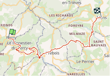
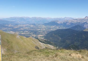
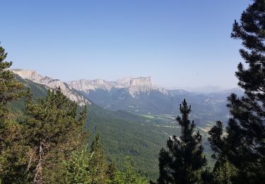
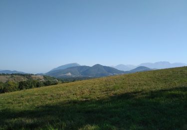
Trail Walking of 16.2 km to be discovered at Auvergne-Rhône-Alpes, Isère, Percy. This trail is proposed by tracegps.
Description
« Sur les pas des Huguenots » consiste en la création d'un sentier international de grande randonnée suivant le tracé historique de l'exil des Huguenots dauphinois vers l'Allemagne et la Suisse après la révocation de l'Edit de Nantes (1685-1690), ainsi que la création de deux itinéraires de l'Italievers la Suisse, l'exode et la Glorieuse Rentrée des Vaudois du Piémont. Au Percy, au niveau du lavoir, prendre à droite le chemin qui descend en direction de Monestier. Après le pont, rester sur le chemin principal qui tire sur la gauche. Aller jusqu’à Monestier du Percy.Contourner l’église par la droite, puis prendre à gauche, puis à droite direction “Mens / Prébois ”. Descendre sur la route et, avant la sortie du village, prendre la route et le chemin qui descendent aux “ Bayles ” sur 150m, au niveau du transformateur. Aux “Bayles”, emprunter la route départementale D252.Au croisement, laisser la route départementale D253a (“ Prébois ”) et continuer tout droit jusqu’à trouver le sentier au “ Souberat”. Traverser la route et continuer en suivant la direction de Prébois. A la fourche (poteau directionnel “ Bayardières”), prendre la direction “ Serrya ”. Au Serre, prendre la route à droite, laisser un premier sentier à gauche et prendre le second direction “ Prébois / Saut du Loup ”. Arrivé à la route, prendre à gauche, puis suivre la route départementale D 253 qui descend en lacets. Après avoir traversé l’Ebron, continuer sur la route départementale D 253 et prendre ensuite le sentier qui monte tout droit. Retrouver, à gauche, la route qui mène à Prébois. Au lavoir, prendre à droite, puis de suite à gauche la rue qui descend. Continuer tout droit jusqu’à la croix. Monter à droite en direction de Mens (poteau directionnel “ Veyre Eycour ”, direction Mens). Vous allez passer par un pont en bois. Emprunter ce chemin jusqu’au “Mas Martinenc ” et garder la direction de Mens. Passer au-dessus du Mas et, au bout du champ, tourner à gauche (balisage VTT rouge n°5). Laisser un chemin à droite. Attention, les ornières sont inondées par mauvais temps. Au “ Flachet ”, continuer tout droit. Au carrefour suivant, toujours continuer tout droit. A “Margounon ”, prendre tout droit et descendre au “Moulin de Chardeyre ”. Après le moulin, prendre le sentier à droite qui mène à “ Beaumet ”. Alterner entre route et chemin pour arriver à Mens. Retrouvez le guide étape n° 10 sur le site « Sur les Pas des Huguenots ».
Positioning
Comments
Trails nearby
![Trail Walking Chichilianne - Le Platary - Photo](https://media.geolcdn.com/t/375/260/ext.jpg?maxdim=2&url=https%3A%2F%2Fservices.sitytrail.com%2FGeolivesWS%2FDownloadMedia.ashx%3FTrailID%3D836793%26Media%3Dfix__20170928142121.jpg)
![Walking Walking](https://static1.geolcdn.com/sitytour/trail-icons/101.png)
Walking
![](/images/other/stat-length.png)
![](https://static1.geolcdn.com/siteimages/upload/files/16400158638029165_repeat_loop_refresh_sync_direction_icon.png)
![Trail Walking Châtillon-en-Diois - La boucle du Mont Barral - Photo](https://media.geolcdn.com/t/375/260/ext.jpg?maxdim=2&url=https%3A%2F%2Fservices.sitytrail.com%2FGeolivesWS%2FDownloadMedia.ashx%3FTrailID%3D634749%26Media%3Dc20ca353-82d8-44c0-a4a4-ad6f8b92275b.JPG)
![Walking Walking](https://static1.geolcdn.com/sitytour/trail-icons/101.png)
Walking
![](/images/other/stat-length.png)
![](https://static1.geolcdn.com/siteimages/upload/files/16400158638029165_repeat_loop_refresh_sync_direction_icon.png)
![Trail Walking Châtillon-en-Diois - mont barral - Photo](https://media.geolcdn.com/t/375/260/ext.jpg?maxdim=2&url=https%3A%2F%2Fmedia.geolcdn.com%2Ff%2Fc48456c2-74aa-4aa3-bdc3-46c6c449c56c.jpg)
![Walking Walking](https://static1.geolcdn.com/sitytour/trail-icons/101.png)
Walking
![](/images/other/stat-length.png)
![](https://static1.geolcdn.com/siteimages/upload/files/16400158638029165_repeat_loop_refresh_sync_direction_icon.png)
![Trail Walking Châtillon-en-Diois - 26 grimone j1 - Photo](https://media.geolcdn.com/t/375/260/ext.jpg?maxdim=2&url=https%3A%2F%2Fmedia.geolcdn.com%2Ff%2F781a4ae6-6994-4c28-83c7-bfb5368271f2.jpg)
![Walking Walking](https://static1.geolcdn.com/sitytour/trail-icons/101.png)
Walking
![](/images/other/stat-length.png)
![](https://static1.geolcdn.com/siteimages/upload/files/16400158638029165_repeat_loop_refresh_sync_direction_icon.png)
![Trail Walking Châtillon-en-Diois - menée le natal le jocou - Photo](https://media.geolcdn.com/t/375/260/ext.jpg?maxdim=2&url=https%3A%2F%2Fmedia.geolcdn.com%2Ff%2Fe5ed90c8-8f6e-4826-90e8-0106fe799e16.jpg)
![Walking Walking](https://static1.geolcdn.com/sitytour/trail-icons/101.png)
Walking
![](/images/other/stat-length.png)
![](https://static1.geolcdn.com/siteimages/upload/files/16400158638029165_repeat_loop_refresh_sync_direction_icon.png)
![Trail Walking Châtillon-en-Diois - jocou par le mont Barral depuis le col de Menée - Photo](https://media.geolcdn.com/t/375/260/ext.jpg?maxdim=2&url=https%3A%2F%2Fmedia.geolcdn.com%2Ff%2F64e40fd7-c62e-4641-8909-9883c0523bbe.jpg)
![Walking Walking](https://static1.geolcdn.com/sitytour/trail-icons/101.png)
Walking
![](/images/other/stat-length.png)
![](https://static1.geolcdn.com/siteimages/upload/files/16400158638029165_repeat_loop_refresh_sync_direction_icon.png)
![Trail Walking Chichilianne - Tete de Praortzel et Crête de Grande Leirie - Photo](https://media.geolcdn.com/t/375/260/ext.jpg?maxdim=2&url=https%3A%2F%2Fmedia.geolcdn.com%2Ff%2F1c9d86f4-51eb-459b-8294-d06675410924.jpg)
![Walking Walking](https://static1.geolcdn.com/sitytour/trail-icons/101.png)
Walking
![](/images/other/stat-length.png)
![](https://static1.geolcdn.com/siteimages/upload/files/16400158638029165_repeat_loop_refresh_sync_direction_icon.png)
![Trail Walking Percy - LE PERCU - Photo](https://media.geolcdn.com/t/375/260/ext.jpg?maxdim=2&url=https%3A%2F%2Fmedia.geolcdn.com%2Ff%2Fcbff7f98-bf67-4537-b31a-bdb3d4f81aa4.jpg)
![Walking Walking](https://static1.geolcdn.com/sitytour/trail-icons/101.png)
Walking
![](/images/other/stat-length.png)
![](https://static1.geolcdn.com/siteimages/upload/files/16400158638029165_repeat_loop_refresh_sync_direction_icon.png)
![Trail Walking Châtillon-en-Diois - pp mont barral - Photo](https://media.geolcdn.com/t/375/260/ext.jpg?maxdim=2&url=https%3A%2F%2Fservices.sitytrail.com%2FGeolivesWS%2FDownloadMedia.ashx%3FTrailID%3D210658%26Media%3Dfix__20130806124828.jpg)
![Walking Walking](https://static1.geolcdn.com/sitytour/trail-icons/101.png)
Walking
![](/images/other/stat-length.png)
![](https://static1.geolcdn.com/siteimages/upload/files/16400158638029165_repeat_loop_refresh_sync_direction_icon.png)