![](/images/other/stat-length.png)
![Trail Mountain bike Pardailhan - Grande Traversée de l'Hérault à VTT - itinéraire Sud - de Rodomouls à Vieulac - Photo](https://media.geolcdn.com/t/1900/400/ext.pjpeg?maxdim=2&url=https%3A%2F%2Fservices.sitytrail.com%2FGeolivesWS%2FDownloadMedia.ashx%3FTrailID%3D107575%26Media%3D12526_2.jpg)
Grande Traversée de l'Hérault à VTT - itinéraire Sud - de Rodomouls à Vieulac
tracegps
User
![Length](/images/other/stat-length.png)
![Max alt](https://static1.geolcdn.com/siteimages/upload/files/1508320355ic_sort_altitude_max_24dp.png)
![Uphill gradient](https://static1.geolcdn.com/siteimages/upload/files/1508320355ic_sort_den_pos_24dp.png)
![Km-Effort](/images/other/stat-length.png)
![Min alt](https://static1.geolcdn.com/siteimages/upload/files/1508320355ic_sort_altitude_min_24dp.png)
![Downhill gradient](https://static1.geolcdn.com/siteimages/upload/files/1508320355ic_sort_den_neg_24dp.png)
![Boucle](https://static1.geolcdn.com/siteimages/upload/files/16400158638029165_repeat_loop_refresh_sync_direction_icon.png)
![Mountain bike](https://static1.geolcdn.com/sitytour/trail-icons/202.png)
4h30
Difficulty : Difficult
![Scan this QR Code to open this trail in the SityTrail application](https://capi.geolives.com/qq0zvz2zws4bq2lad0pu/sitytour/trails/107575/qr.png?size=200)
FREE GPS app for hiking
About
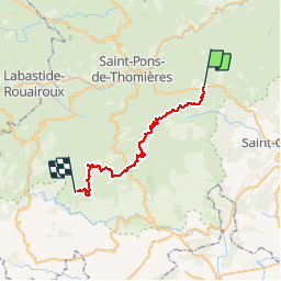
Trail Mountain bike of 31 km to be discovered at Occitania, Hérault, Pardailhan. This trail is proposed by tracegps.
Description
Grande Traversée de l'Hérault à VTT - itinéraire Sud - de Rodomouls à Vieulac. Itinéraire officiel s'appuyant sur le Réseau Vert® et labellisé par la Fédération Française de Cyclisme. Grâce à la forme de son corps et à l’épaisseur de sa peau, le sanglier peut se frayer des passages là où d'autres animaux seraient bien incapables de passer. S’ils sont d’assez petite taille par rapport à leurs cousins du nord de la France, certains vieux mâles de notre région peuvent cependant dépasser allègrement les 100kg. Leur vue n’est pas très perçante, mais leur odorat et leur ouïe sont très fins. Omnivores, ils fouillent le sol avec leur groin à la recherche de glands, de racines ou d’insectes. Tout au long de ce chemin, vous pourrez voir des sols totalement retournés, signe de leur récent passage. Téléchargez la fiche de ce tronçon. Cet itinéraire est accessible aux randonneurs à pied et aux cavaliers en suivant les bornes vertes. Le balisage de la Grande Traversée est à double sens alors que le Réseau Vert est balisé dans le sens Est-Ouest.
Positioning
Comments
Trails nearby
![Trail Walking Riols - Autour d'Olargues 2 - Photo](https://media.geolcdn.com/t/375/260/65dc6720-fc5c-43b9-8927-7867e5c86bd4.jpg&format=jpg&maxdim=2)
![Walking Walking](https://static1.geolcdn.com/sitytour/trail-icons/101.png)
Walking
![](/images/other/stat-length.png)
![](https://static1.geolcdn.com/siteimages/upload/files/16400158638029165_repeat_loop_refresh_sync_direction_icon.png)
![Trail Walking Ferrières-Poussarou - Crêtes du Matas - Photo](https://media.geolcdn.com/t/375/260/026945f3-2994-4889-bc75-0599a1eb1836.jpg&format=jpg&maxdim=2)
![Walking Walking](https://static1.geolcdn.com/sitytour/trail-icons/101.png)
Walking
![](/images/other/stat-length.png)
![](https://static1.geolcdn.com/siteimages/upload/files/16400158638029165_repeat_loop_refresh_sync_direction_icon.png)
![Trail On foot Riols - Notre-Dame de Tredos - Photo](https://media.geolcdn.com/t/375/260/add3e184-ee16-4484-b059-9139dfec197d.jpeg&format=jpg&maxdim=2)
![On foot On foot](https://static1.geolcdn.com/sitytour/trail-icons/100.png)
On foot
![](/images/other/stat-length.png)
![](https://static1.geolcdn.com/siteimages/upload/files/16400158638029165_repeat_loop_refresh_sync_direction_icon.png)
![Trail Walking Riols - Riols - Notre-Dame-de-Tredos - Photo](https://media.geolcdn.com/t/375/260/5e41fb0d-22a3-44d1-ad63-968d014b4bfc.jpg&format=jpg&maxdim=2)
![Walking Walking](https://static1.geolcdn.com/sitytour/trail-icons/101.png)
Walking
![](/images/other/stat-length.png)
![](https://static1.geolcdn.com/siteimages/upload/files/16400158638029165_repeat_loop_refresh_sync_direction_icon.png)
![Trail Walking Riols - ND_de_Tredos - Photo](https://media.geolcdn.com/t/375/260/ext.jpg?maxdim=2&url=https%3A%2F%2Fstatic1.geolcdn.com%2Fsiteimages%2Fupload%2Ffiles%2F1553511878bg_sport_marche.png)
![Walking Walking](https://static1.geolcdn.com/sitytour/trail-icons/101.png)
Walking
![](/images/other/stat-length.png)
![](https://static1.geolcdn.com/siteimages/upload/files/16400158638029165_repeat_loop_refresh_sync_direction_icon.png)
![Trail Walking Riols - rando riols - Photo](https://media.geolcdn.com/t/375/260/ext.jpg?maxdim=2&url=https%3A%2F%2Fservices.sitytrail.com%2FGeolivesWS%2FDownloadMedia.ashx%3FTrailID%3D731549%26Media%3Dfix__20170412151114.jpg)
![Walking Walking](https://static1.geolcdn.com/sitytour/trail-icons/101.png)
![Trail Walking Riols - rando riols - Photo](https://media.geolcdn.com/t/375/260/ext.jpg?maxdim=2&url=https%3A%2F%2Fservices.sitytrail.com%2FGeolivesWS%2FDownloadMedia.ashx%3FTrailID%3D731544%26Media%3Dfix__20170412151114.jpg)
![Walking Walking](https://static1.geolcdn.com/sitytour/trail-icons/101.png)
![Trail Walking Saint-Étienne-d'Albagnan - Tredos Rodomoul - Photo](https://media.geolcdn.com/t/375/260/ext.jpg?maxdim=2&url=https%3A%2F%2Fservices.sitytrail.com%2FGeolivesWS%2FDownloadMedia.ashx%3FTrailID%3D461210%26Media%3Dbb097b58-92af-4293-b3c7-cea85d32e5c6.JPG)
![Walking Walking](https://static1.geolcdn.com/sitytour/trail-icons/101.png)
Walking
![](/images/other/stat-length.png)
![](https://static1.geolcdn.com/siteimages/upload/files/16400158638029165_repeat_loop_refresh_sync_direction_icon.png)
![Trail Walking Babeau-Bouldoux - BABEAU - Photo](https://media.geolcdn.com/t/375/260/ext.jpg?maxdim=2&url=https%3A%2F%2Fstatic1.geolcdn.com%2Fsiteimages%2Fupload%2Ffiles%2F1553511878bg_sport_marche.png)
![Walking Walking](https://static1.geolcdn.com/sitytour/trail-icons/101.png)
Walking
![](/images/other/stat-length.png)
![](https://static1.geolcdn.com/siteimages/upload/files/16400158638029165_repeat_loop_refresh_sync_direction_icon.png)
formidable