![](/images/other/stat-length.png)
![Trail Mountain bike Voiteur - Centre VTT FFC Premier Plateau, entre Lacs et Vignobles - Les Châteaux - Circuit n°8 - Photo](https://media.geolcdn.com/t/1900/400/ext.pjpeg?maxdim=2&url=https%3A%2F%2Fservices.sitytrail.com%2FGeolivesWS%2FDownloadMedia.ashx%3FTrailID%3D107546%26Media%3D12504_1.jpg)
Centre VTT FFC Premier Plateau, entre Lacs et Vignobles - Les Châteaux - Circuit n°8
tracegps
User
![Length](/images/other/stat-length.png)
![Max alt](https://static1.geolcdn.com/siteimages/upload/files/1508320355ic_sort_altitude_max_24dp.png)
![Uphill gradient](https://static1.geolcdn.com/siteimages/upload/files/1508320355ic_sort_den_pos_24dp.png)
![Km-Effort](/images/other/stat-length.png)
![Min alt](https://static1.geolcdn.com/siteimages/upload/files/1508320355ic_sort_altitude_min_24dp.png)
![Downhill gradient](https://static1.geolcdn.com/siteimages/upload/files/1508320355ic_sort_den_neg_24dp.png)
![Boucle](https://static1.geolcdn.com/siteimages/upload/files/16400158638029165_repeat_loop_refresh_sync_direction_icon.png)
![Mountain bike](https://static1.geolcdn.com/sitytour/trail-icons/202.png)
1h30
Difficulty : Very difficult
![Scan this QR Code to open this trail in the SityTrail application](https://capi.geolives.com/qq0zvz2zws4bq2lad0pu/sitytour/trails/107546/qr.png?size=200)
FREE GPS app for hiking
About
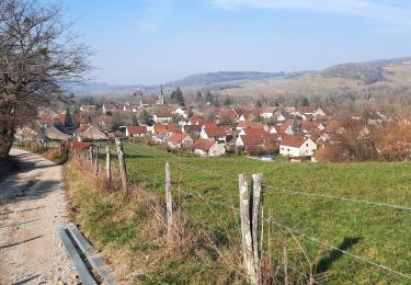
Trail Mountain bike of 14.5 km to be discovered at Bourgogne-Franche-Comté, Jura, Voiteur. This trail is proposed by tracegps.
Description
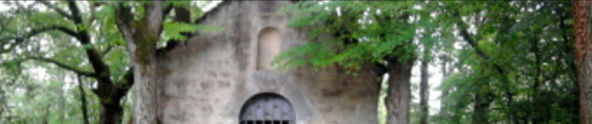
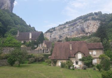
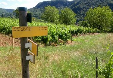
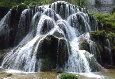
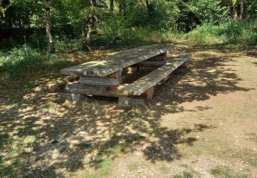
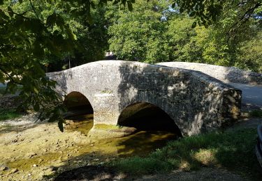
Centre VTT - FFC Premier Plateau, entre Lacs et Vignobles. Circuit officiel labellisé par la Fédération Française de Cyclisme. Au départ de Voiteur, 5 circuits vous guideront à la découverte des trésors des Coteaux de la Haute Seille : un vignoble de renommée internationale, une architecture médiévale préservée et des curiosités géologiques à couper le souffle. Sur un terrain vallonné, vous partirez à travers vignes, bois et prairies, découvrir les châteaux de Domblans, Blandans, Frontenay et Menetru-le-Vignoble, qui jadis protégeaient la route du Sel, entre Salins-les-Bains et Lons-le-Saunier. Ce tracé a été relevé sur le terrain par le club Vtt Conliège.
Positioning
Comments
Trails nearby
![Trail Walking Baume-les-Messieurs - Baume-les-Messieurs - Photo](https://media.geolcdn.com/t/375/260/ext.jpg?maxdim=2&url=https%3A%2F%2Fservices.sitytrail.com%2FGeolivesWS%2FDownloadMedia.ashx%3FTrailID%3D792634%26Media%3Dfix__20170719130529.jpg)
![Walking Walking](https://static1.geolcdn.com/sitytour/trail-icons/101.png)
Walking
![](/images/other/stat-length.png)
![](https://static1.geolcdn.com/siteimages/upload/files/16400158638029165_repeat_loop_refresh_sync_direction_icon.png)
![Trail Walking Nevy-sur-Seille - Nevy sur Seille - Photo](https://media.geolcdn.com/t/375/260/ext.jpg?maxdim=2&url=https%3A%2F%2Fservices.sitytrail.com%2FGeolivesWS%2FDownloadMedia.ashx%3FTrailID%3D318271%26Media%3Dfix__20140626161613.jpg)
![Walking Walking](https://static1.geolcdn.com/sitytour/trail-icons/101.png)
Walking
![](/images/other/stat-length.png)
![](https://static1.geolcdn.com/siteimages/upload/files/16400158638029165_repeat_loop_refresh_sync_direction_icon.png)
![Trail Walking Baume-les-Messieurs - Baume Les Messieurs Falaises et Reculées page 148 - Photo](https://media.geolcdn.com/t/375/260/acd5524e-71ab-4cdd-8d98-f51002ff3690.jpg&format=jpg&maxdim=2)
![Walking Walking](https://static1.geolcdn.com/sitytour/trail-icons/101.png)
Walking
![](/images/other/stat-length.png)
![](https://static1.geolcdn.com/siteimages/upload/files/16400158638029165_repeat_loop_refresh_sync_direction_icon.png)
![Trail Mountain bike Voiteur - Centre VTT FFC Premier Plateau, entre Lacs et Vignobles - La Seille - Circuit n°4 - Photo](https://media.geolcdn.com/t/375/260/ext.jpg?maxdim=2&url=https%3A%2F%2Fservices.sitytrail.com%2FGeolivesWS%2FDownloadMedia.ashx%3FTrailID%3D107544%26Media%3D12502_2.jpg)
![Mountain bike Mountain bike](https://static1.geolcdn.com/sitytour/trail-icons/202.png)
Mountain bike
![](/images/other/stat-length.png)
![](https://static1.geolcdn.com/siteimages/upload/files/16400158638029165_repeat_loop_refresh_sync_direction_icon.png)
![Trail Walking Château-Chalon - Château-Chalon boucle 11km - Photo](https://media.geolcdn.com/t/375/260/155ad306-7f99-426a-8752-9f602e95d13c.jpg&format=jpg&maxdim=2)
![Walking Walking](https://static1.geolcdn.com/sitytour/trail-icons/101.png)
Walking
![](/images/other/stat-length.png)
![](https://static1.geolcdn.com/siteimages/upload/files/16400158638029165_repeat_loop_refresh_sync_direction_icon.png)
![Trail Walking Domblans - 2019-10-02_17h23m41_Projet Domblans - Photo](https://media.geolcdn.com/t/375/260/ext.jpg?maxdim=2&url=https%3A%2F%2Fstatic1.geolcdn.com%2Fsiteimages%2Fupload%2Ffiles%2F1553511878bg_sport_marche.png)
![Walking Walking](https://static1.geolcdn.com/sitytour/trail-icons/101.png)
Walking
![](/images/other/stat-length.png)
![](https://static1.geolcdn.com/siteimages/upload/files/16400158638029165_repeat_loop_refresh_sync_direction_icon.png)
![Trail Walking Baume-les-Messieurs - Reculée de Baume-les-Messieurs - Photo](https://media.geolcdn.com/t/375/260/ext.jpg?maxdim=2&url=https%3A%2F%2Fstatic1.geolcdn.com%2Fsiteimages%2Fupload%2Ffiles%2F1553511878bg_sport_marche.png)
![Walking Walking](https://static1.geolcdn.com/sitytour/trail-icons/101.png)
Walking
![](/images/other/stat-length.png)
![](https://static1.geolcdn.com/siteimages/upload/files/16400158638029165_repeat_loop_refresh_sync_direction_icon.png)
![Trail Walking Baume-les-Messieurs - Baume les messieurs les échelles de Sermu page 166 - Photo](https://media.geolcdn.com/t/375/260/98bc4c1d-13b5-43da-8ac3-6d94a6c79eb7.jpg&format=jpg&maxdim=2)
![Walking Walking](https://static1.geolcdn.com/sitytour/trail-icons/101.png)
Walking
![](/images/other/stat-length.png)
![](https://static1.geolcdn.com/siteimages/upload/files/16400158638029165_repeat_loop_refresh_sync_direction_icon.png)
![Trail Walking Baume-les-Messieurs - Le tour du Cirque de Baume-les-Messieurs - Photo](https://media.geolcdn.com/t/375/260/65149169-0d37-4056-8013-6b139c605190.jpg&format=jpg&maxdim=2)
![Walking Walking](https://static1.geolcdn.com/sitytour/trail-icons/101.png)
Walking
![](/images/other/stat-length.png)
![](https://static1.geolcdn.com/siteimages/upload/files/16400158638029165_repeat_loop_refresh_sync_direction_icon.png)