![](/images/other/stat-length.png)
![Trail Walking Thevet-Saint-Julien - Campagne berrichonne : autour de Thévet Saint-Julien - Photo](https://media.geolcdn.com/t/1900/400/ext.pjpeg?maxdim=2&url=https%3A%2F%2Fstatic1.geolcdn.com%2Fsiteimages%2Fupload%2Ffiles%2F1553511878bg_sport_marche.png)
Campagne berrichonne : autour de Thévet Saint-Julien
tracegps
User
![Length](/images/other/stat-length.png)
Length
20 km
![Max alt](https://static1.geolcdn.com/siteimages/upload/files/1508320355ic_sort_altitude_max_24dp.png)
Max alt
260 m
![Uphill gradient](https://static1.geolcdn.com/siteimages/upload/files/1508320355ic_sort_den_pos_24dp.png)
Uphill gradient
200 m
![Km-Effort](/images/other/stat-length.png)
Km-Effort
23 km
![Min alt](https://static1.geolcdn.com/siteimages/upload/files/1508320355ic_sort_altitude_min_24dp.png)
Min alt
188 m
![Downhill gradient](https://static1.geolcdn.com/siteimages/upload/files/1508320355ic_sort_den_neg_24dp.png)
Downhill gradient
201 m
![Boucle](https://static1.geolcdn.com/siteimages/upload/files/16400158638029165_repeat_loop_refresh_sync_direction_icon.png)
Boucle
Yes
Creation date :
2014-12-10 00:00:00.0
Updated on :
2014-12-10 00:00:00.0
![Walking](https://static1.geolcdn.com/sitytour/trail-icons/101.png)
5h00
Difficulty : Medium
![Scan this QR Code to open this trail in the SityTrail application](https://capi.geolives.com/qq0zvz2zws4bq2lad0pu/sitytour/trails/107462/qr.png?size=200)
FREE GPS app for hiking
About
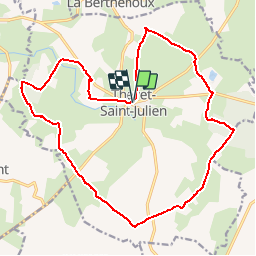
Trail Walking of 20 km to be discovered at Centre-Loire Valley, Indre, Thevet-Saint-Julien. This trail is proposed by tracegps.
Description
Situé à proximité de La Châtre, Thévet Saint-Julien est un village perdu au milieu de la campagne berrichonne. La balade digestive proposée emprunte une partie du GR des "Maîtres Sonneurs", nom donné en hommage au livre de Georges Sand "Les Maître Sonneurs", qui raconte l'histoire de l'un de ces musiciens.
Positioning
Country:
France
Region :
Centre-Loire Valley
Department/Province :
Indre
Municipality :
Thevet-Saint-Julien
Location:
Unknown
Start:(Dec)
Start:(UTM)
428738 ; 5165298 (31T) N.
Comments
Trails nearby
![Trail Walking La Berthenoux - Sur les pas des Maîtres Sonneurs (La Berthenoux - La Motte-Feuilly) - Photo](https://media.geolcdn.com/t/375/260/ext.jpg?maxdim=2&url=https%3A%2F%2Fservices.sitytrail.com%2FGeolivesWS%2FDownloadMedia.ashx%3FTrailID%3D172459%26Media%3D13819_5.jpg)
![Walking Walking](https://static1.geolcdn.com/sitytour/trail-icons/101.png)
Sur les pas des Maîtres Sonneurs (La Berthenoux - La Motte-Feuilly)
Walking
Difficult
La Berthenoux,
Centre-Loire Valley,
Indre,
France
![](/images/other/stat-length.png)
19 km | 21 km-effort
4h 45min
![](https://static1.geolcdn.com/siteimages/upload/files/16400158638029165_repeat_loop_refresh_sync_direction_icon.png)
No
![Trail Walking Lourouer-Saint-Laurent - Circuit pédestre n°34](https://media.geolcdn.com/t/375/260/ext.jpg?maxdim=2&url=https%3A%2F%2Fstatic1.geolcdn.com%2Fsiteimages%2Fupload%2Ffiles%2F1553511878bg_sport_marche.png)
![Walking Walking](https://static1.geolcdn.com/sitytour/trail-icons/101.png)
Circuit pédestre n°34 "légendes et mystères"
Walking
Medium
Lourouer-Saint-Laurent,
Centre-Loire Valley,
Indre,
France
![](/images/other/stat-length.png)
6.4 km | 7.1 km-effort
1h 36min
![](https://static1.geolcdn.com/siteimages/upload/files/16400158638029165_repeat_loop_refresh_sync_direction_icon.png)
Yes
![Trail Walking Thevet-Saint-Julien - Circuit pédestre n°42](https://media.geolcdn.com/t/375/260/ext.jpg?maxdim=2&url=https%3A%2F%2Fstatic1.geolcdn.com%2Fsiteimages%2Fupload%2Ffiles%2F1553511878bg_sport_marche.png)
![Walking Walking](https://static1.geolcdn.com/sitytour/trail-icons/101.png)
Circuit pédestre n°42 "sur la ligne de crête de la vallée noire"
Walking
Medium
Thevet-Saint-Julien,
Centre-Loire Valley,
Indre,
France
![](/images/other/stat-length.png)
7.7 km | 8.9 km-effort
2h 1min
![](https://static1.geolcdn.com/siteimages/upload/files/16400158638029165_repeat_loop_refresh_sync_direction_icon.png)
Yes
![Trail Walking Verneuil-sur-Igneraie - vic-20191016 - Photo](https://media.geolcdn.com/t/375/260/ext.jpg?maxdim=2&url=https%3A%2F%2Fstatic1.geolcdn.com%2Fsiteimages%2Fupload%2Ffiles%2F1553511878bg_sport_marche.png)
![Walking Walking](https://static1.geolcdn.com/sitytour/trail-icons/101.png)
vic-20191016
Walking
Very easy
Verneuil-sur-Igneraie,
Centre-Loire Valley,
Indre,
France
![](/images/other/stat-length.png)
8.1 km | 10 km-effort
2h 13min
![](https://static1.geolcdn.com/siteimages/upload/files/16400158638029165_repeat_loop_refresh_sync_direction_icon.png)
No