Trail Mountain bike Labastide-Paumès - De Fabas à la vallée du Touch  et le GR 86 - Photo

De Fabas à la vallée du Touch et le GR 86

 tracegps
tracegps

User

© OpenStreetMap contributors
Length
Length
25 km
Max alt
Max alt
386 m
Uphill gradient
Uphill gradient
380 m
Km-Effort
Km-Effort  
30 km
Min alt
Min alt
258 m
Downhill gradient
Downhill gradient
379 m
Boucle
Boucle
Yes
Creation date :
2014-12-10 00:00:00.0
Updated on :
2014-12-10 00:00:00.0

(0 Reviews)

Mountain bike
Mountain bike
1h30
Difficulty : Medium

Scan this QR Code to open this trail in the SityTrail application

FREE GPS app for hiking

Logo SityTrail SityTrail

IGN / Geographical institutes

Download SityTrail from the App Store Download SityTrail from Google Play

Logo SityTrail SityTrail World

The world is yours!

Download SityTrail from the App Store Download SityTrail from Google Play Download SityTrail on Huawei AppGallery

About

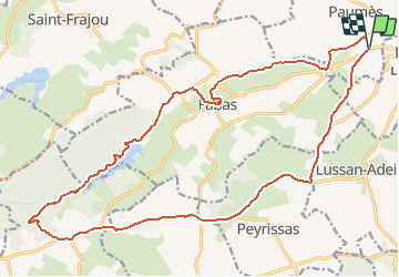
Trail Mountain bike of 25 km to be discovered at Occitania, Haute-Garonne, Labastide-Paumès. This trail is proposed by tracegps.

Description

Circuit autour de Fabas; on parcourt la vallée du Touch dans sa belle partie, on peut éviter la rude montée à Fabas où le challenge sera de rester en selle. La suite au bord du lac est très dépaysante avec des résineux et des feuillus magnifiques en automne. La montée sur les crêtes par une belle piste forestière, achève la partie VTT sur le GR 86. Le retour se fait en goudron par une petite route extrêmement panoramique.

Elevation profile

Positioning

Country:
France
Region :
Occitania
Department/Province :
Haute-Garonne
Municipality :
Labastide-Paumès
Location:
Unknown
Start:(UTM)
333073 ; 4799148 (31T) N.

Trails nearby

Trail Walking Agassac - 31.Agassac.25 aout - Photo
Walking
veronique berbiguier

Walking

Difficult
Agassac, Occitania, Haute-Garonne, France
10.3 km | 13.7 km-effort
3h 52min
Yes
Trail Walking Sénarens - Randonnée senarens - Photo
Walking
Fafou64

Walking

Sénarens, Occitania, Haute-Garonne, France
11.5 km | 14.1 km-effort
2h 43min
Yes
Trail Walking Agassac - Agassac - Photo
Walking
Fafou64

Walking

Medium
Agassac, Occitania, Haute-Garonne, France
8.7 km | 11.9 km-effort
2h 5min
No
Trail Walking Agassac - Agassac - Photo
Walking

Walking

Easy
Agassac, Occitania, Haute-Garonne, France
9.3 km | 12.6 km-effort
2h 15min
Yes
Trail On foot Fabas - Foret de Fabas - Photo
On foot
philou6351

On foot

Very easy
Fabas, Occitania, Haute-Garonne, France
12.6 km | 15.6 km-effort
Unknown
Yes


Close
My subscriptions