Trail Walking Lespinassière - Le Rocher de Peyremaux - Lespinassière - Photo

Le Rocher de Peyremaux - Lespinassière

 tracegps
tracegps

User

© OpenStreetMap contributors
Length
Length
32 km
Max alt
Max alt
1048 m
Uphill gradient
Uphill gradient
1617 m
Km-Effort
Km-Effort  
54 km
Min alt
Min alt
314 m
Downhill gradient
Downhill gradient
1614 m
Boucle
Boucle
Yes
Creation date :
2014-12-10 00:00:00.0
Updated on :
2014-12-10 00:00:00.0

(0 Reviews)

Walking
Walking
5h00
Difficulty : Difficult

Scan this QR Code to open this trail in the SityTrail application

FREE GPS app for hiking

Logo SityTrail SityTrail

IGN / Geographical institutes

Download SityTrail from the App Store Download SityTrail from Google Play

Logo SityTrail SityTrail World

The world is yours!

Download SityTrail from the App Store Download SityTrail from Google Play Download SityTrail on Huawei AppGallery

About

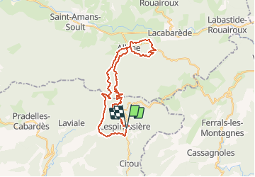
Trail Walking of 32 km to be discovered at Occitania, Aude, Lespinassière. This trail is proposed by tracegps.

Description

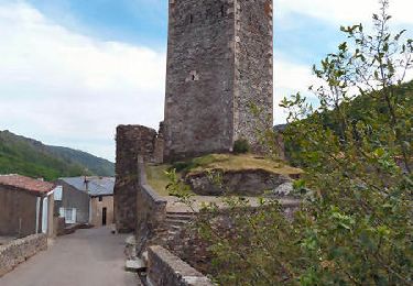
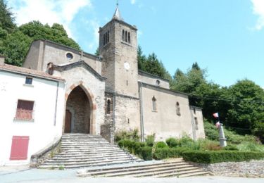
Superbe circuit qui vous fera découvrir le versant Nord de la Montagne Noire. Descente jusqu'à Albine par le monument commémorant le crash d'un aéronef de l'aéropostale (point de vue), remontée sportive dans un bois de hêtres tapissé de mousse jusqu'au Rocher de Peyremaux (belvédère). A faire par ciel dégagé. Vous pouvez écourter cette randonnée en remontant directement à partir du centre du village d'Albine au Roc de Peyremaux. Vous éviterez le circuit de Candesoubre que vous pouvez effectuer lors d'une autre randonnée. Dans ce cas, le Roc de Peyremaux par Albine ne fera que 25 km pour 1533 m de D . La remontée de la rivière par le circuit de Candesoubre fait 7 km pour 300 m de D ."

Elevation profile

Positioning

Country:
France
Region :
Occitania
Department/Province :
Aude
Municipality :
Lespinassière
Location:
Unknown
Start:(UTM)
462706 ; 4805678 (31T) N.

Comments

Please log in to post a review or rate the element


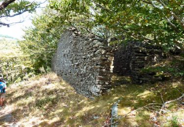
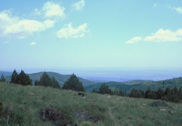
Fais le dimanche 23/02/2020 au départ du village de Lespinassière (Aude) circuit : Lespinassière/Serre d'Alaric. Circuit extrêmement varié de par la végétation tout le long de ce parcourt, panorama +++ (Pic de Nôre, Pyrénées, Mer, Caroux, etc...) magnifique ! Très beau circuit de randonnée, sans grande difficulté, mais avec quelques montées raides et descentes aussi raides.


Trails nearby

Trail Walking Castans - Boucle des ruisseaux - Castans - Photo
Walking
tracegps

Walking

Medium
(5)
Castans, Occitania, Aude, France
6.4 km | 10 km-effort
4h 0min
Yes
Trail Walking Lacabarède - Fontaine des 3 Eveques - Photo
Walking
tracegps

Walking

Medium
(1)
Lacabarède, Occitania, Tarn, France
12.9 km | 17.9 km-effort
4h 0min
Yes
Trail Walking Villeneuve-Minervois - pujol de bosc castanviel - Photo
Walking
henribatut

Walking

Easy
Villeneuve-Minervois, Occitania, Aude, France
15.9 km | 23 km-effort
5h 20min
Yes
Trail Walking Citou - Citou et sa château - Photo
Walking
jsaun

Walking

Medium
Citou, Occitania, Aude, France
18.6 km | 26 km-effort
4h 12min
No
Trail Walking Lespinassière - Salette -Chiffre - Photo
Walking
jsaun

Walking

Medium
(1)
Lespinassière, Occitania, Aude, France
9.6 km | 13.9 km-effort
2h 32min
No
Trail Walking Lespinassière - Lespinassière - La Serre d'Alaric - Photo
Walking
tracegps

Walking

Medium
Lespinassière, Occitania, Aude, France
19.1 km | 29 km-effort
6h 30min
Yes
Trail Walking Castans - Le Quiersboutou - Castans - Photo
Walking
tracegps

Walking

Medium
Castans, Occitania, Aude, France
7.8 km | 14.8 km-effort
4h 30min
Yes
Trail Walking Castans - Les crêtes de San Marty - Castans Hameau de Laviale - Photo
Walking
tracegps

Walking

Difficult
Castans, Occitania, Aude, France
17.8 km | 26 km-effort
5h 0min
Yes
Trail Walking Castans - San Marti - Laviale - Photo
Walking
tracegps

Walking

Difficult
Castans, Occitania, Aude, France
17.7 km | 27 km-effort
5h 0min
Yes


Close
My subscriptions