![](/images/other/stat-length.png)
![Trail Walking Siguer - Etangs de Neych, des Redouneilles des Vaches et de Peyregrand - Photo](https://media.geolcdn.com/t/1900/400/ext.pjpeg?maxdim=2&url=https%3A%2F%2Fstatic1.geolcdn.com%2Fsiteimages%2Fupload%2Ffiles%2F1553511878bg_sport_marche.png)
Etangs de Neych, des Redouneilles des Vaches et de Peyregrand
tracegps
User
![Length](/images/other/stat-length.png)
Length
19.3 km
![Max alt](https://static1.geolcdn.com/siteimages/upload/files/1508320355ic_sort_altitude_max_24dp.png)
Max alt
2488 m
![Uphill gradient](https://static1.geolcdn.com/siteimages/upload/files/1508320355ic_sort_den_pos_24dp.png)
Uphill gradient
1598 m
![Km-Effort](/images/other/stat-length.png)
Km-Effort
41 km
![Min alt](https://static1.geolcdn.com/siteimages/upload/files/1508320355ic_sort_altitude_min_24dp.png)
Min alt
956 m
![Downhill gradient](https://static1.geolcdn.com/siteimages/upload/files/1508320355ic_sort_den_neg_24dp.png)
Downhill gradient
1598 m
![Boucle](https://static1.geolcdn.com/siteimages/upload/files/16400158638029165_repeat_loop_refresh_sync_direction_icon.png)
Boucle
Yes
Creation date :
2014-12-10 00:00:00.0
Updated on :
2014-12-10 00:00:00.0
![Walking](https://static1.geolcdn.com/sitytour/trail-icons/101.png)
8h00
Difficulty : Very difficult
![Scan this QR Code to open this trail in the SityTrail application](https://capi.geolives.com/qq0zvz2zws4bq2lad0pu/sitytour/trails/107401/qr.png?size=200)
FREE GPS app for hiking
About
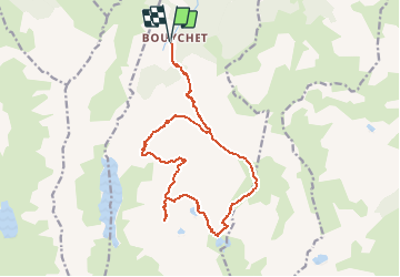
Trail Walking of 19.3 km to be discovered at Occitania, Ariège, Siguer. This trail is proposed by tracegps.
Description
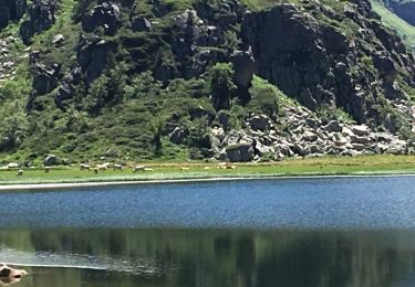
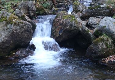
Départ du parking de Bouychet pour une longue randonnée de 20 km et 1730 m de D à travers de très beaux lacs. Retour par la jasse de Brouquenat d'en haut et sa cabane.
Positioning
Country:
France
Region :
Occitania
Department/Province :
Ariège
Municipality :
Siguer
Location:
Unknown
Start:(Dec)
Start:(UTM)
381181 ; 4731794 (31T) N.
Comments
Trails nearby
![Trail Walking Auzat - lac dizourtG3 - Photo](https://media.geolcdn.com/t/375/260/f8b766e0-ba89-416c-af4f-05c86a4ad7d4.jpg&format=jpg&maxdim=2)
![Walking Walking](https://static1.geolcdn.com/sitytour/trail-icons/101.png)
lac dizourtG3
Walking
Difficult
(1)
Auzat,
Occitania,
Ariège,
France
![](/images/other/stat-length.png)
7.4 km | 14.3 km-effort
5h 0min
![](https://static1.geolcdn.com/siteimages/upload/files/16400158638029165_repeat_loop_refresh_sync_direction_icon.png)
Yes
![Trail On foot Val-de-Sos - Le Palet de Samsom - Photo](https://media.geolcdn.com/t/375/260/3f092e96-c063-46a3-9421-f94e65e3f3dd.jpeg&format=jpg&maxdim=2)
![On foot On foot](https://static1.geolcdn.com/sitytour/trail-icons/100.png)
Le Palet de Samsom
On foot
Easy
Val-de-Sos,
Occitania,
Ariège,
France
![](/images/other/stat-length.png)
5.8 km | 10.3 km-effort
2h 20min
![](https://static1.geolcdn.com/siteimages/upload/files/16400158638029165_repeat_loop_refresh_sync_direction_icon.png)
Yes
![Trail Walking Lercoul - 2021-09-19_20h11m54_Pic-de-garbie-de-bresoul-depuis-lercoul-19x09x2021 - Photo](https://media.geolcdn.com/t/375/260/82f09742-d952-478c-ab3a-a2125788a8a9.jpg&format=jpg&maxdim=2)
![Walking Walking](https://static1.geolcdn.com/sitytour/trail-icons/101.png)
2021-09-19_20h11m54_Pic-de-garbie-de-bresoul-depuis-lercoul-19x09x2021
Walking
Medium
Lercoul,
Occitania,
Ariège,
France
![](/images/other/stat-length.png)
14.7 km | 28 km-effort
6h 21min
![](https://static1.geolcdn.com/siteimages/upload/files/16400158638029165_repeat_loop_refresh_sync_direction_icon.png)
Yes
![Trail Walking Siguer - col côte 2239m - Photo](https://media.geolcdn.com/t/375/260/d0d85790-0797-4c33-ac54-27f9e26acbc3.jpg&format=jpg&maxdim=2)
![Walking Walking](https://static1.geolcdn.com/sitytour/trail-icons/101.png)
col côte 2239m
Walking
Difficult
Siguer,
Occitania,
Ariège,
France
![](/images/other/stat-length.png)
19.1 km | 38 km-effort
7h 46min
![](https://static1.geolcdn.com/siteimages/upload/files/16400158638029165_repeat_loop_refresh_sync_direction_icon.png)
Yes
![Trail Walking Siguer - Peyregrand - Neych - Photo](https://media.geolcdn.com/t/375/260/5ea5ffe8-b979-4d83-8c7c-cabbb08d7e20.jpg&format=jpg&maxdim=2)
![Walking Walking](https://static1.geolcdn.com/sitytour/trail-icons/101.png)
Peyregrand - Neych
Walking
Difficult
Siguer,
Occitania,
Ariège,
France
![](/images/other/stat-length.png)
19.2 km | 38 km-effort
9h 44min
![](https://static1.geolcdn.com/siteimages/upload/files/16400158638029165_repeat_loop_refresh_sync_direction_icon.png)
Yes
![Trail Walking Siguer - lac de Peyregrand - Photo](https://media.geolcdn.com/t/375/260/ext.jpg?maxdim=2&url=https%3A%2F%2Fservices.sitytrail.com%2FGeolivesWS%2FDownloadMedia.ashx%3FTrailID%3D1015753%26Media%3D20180803133655.jpg)
![Walking Walking](https://static1.geolcdn.com/sitytour/trail-icons/101.png)
lac de Peyregrand
Walking
Medium
Siguer,
Occitania,
Ariège,
France
![](/images/other/stat-length.png)
13.2 km | 25 km-effort
5h 12min
![](https://static1.geolcdn.com/siteimages/upload/files/16400158638029165_repeat_loop_refresh_sync_direction_icon.png)
No
![Trail Walking Auzat - 171008 EnCours - Photo](https://media.geolcdn.com/t/375/260/ext.jpg?maxdim=2&url=https%3A%2F%2Fservices.sitytrail.com%2FGeolivesWS%2FDownloadMedia.ashx%3FTrailID%3D842337%26Media%3Dfix__20171008150048.jpg)
![Walking Walking](https://static1.geolcdn.com/sitytour/trail-icons/101.png)
171008 EnCours
Walking
Very easy
Auzat,
Occitania,
Ariège,
France
![](/images/other/stat-length.png)
7.3 km | 14.2 km-effort
3h 50min
![](https://static1.geolcdn.com/siteimages/upload/files/16400158638029165_repeat_loop_refresh_sync_direction_icon.png)
Yes
![Trail Walking Val-de-Sos - 171007 EnCours - Photo](https://media.geolcdn.com/t/375/260/ext.jpg?maxdim=2&url=https%3A%2F%2Fservices.sitytrail.com%2FGeolivesWS%2FDownloadMedia.ashx%3FTrailID%3D842335%26Media%3Dfix__20171007160032.jpg)
![Walking Walking](https://static1.geolcdn.com/sitytour/trail-icons/101.png)
171007 EnCours
Walking
Very easy
(1)
Val-de-Sos,
Occitania,
Ariège,
France
![](/images/other/stat-length.png)
10.8 km | 17.1 km-effort
4h 50min
![](https://static1.geolcdn.com/siteimages/upload/files/16400158638029165_repeat_loop_refresh_sync_direction_icon.png)
Yes
![Trail Walking Val-de-Sos - 171005 EnCours - Photo](https://media.geolcdn.com/t/375/260/ext.jpg?maxdim=2&url=https%3A%2F%2Fservices.sitytrail.com%2FGeolivesWS%2FDownloadMedia.ashx%3FTrailID%3D842317%26Media%3Dfix__20171005152454.jpg)
![Walking Walking](https://static1.geolcdn.com/sitytour/trail-icons/101.png)
171005 EnCours
Walking
Very easy
Val-de-Sos,
Occitania,
Ariège,
France
![](/images/other/stat-length.png)
7 km | 10.4 km-effort
3h 40min
![](https://static1.geolcdn.com/siteimages/upload/files/16400158638029165_repeat_loop_refresh_sync_direction_icon.png)
Yes
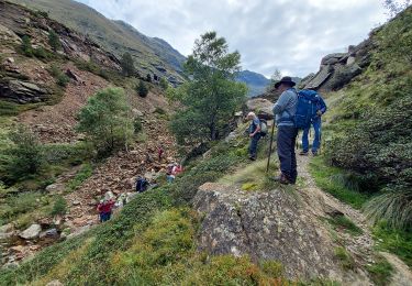
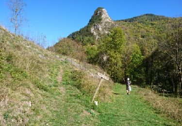
superbe randonnée a refaire avec un peu plus de soleil