![](/images/other/stat-length.png)
![Trail Walking Saint-Germain-la-Montagne - Circuit du Tourniquet - Saint Germain la Montagne - Photo](https://media.geolcdn.com/t/1900/400/ext.pjpeg?maxdim=2&url=https%3A%2F%2Fservices.sitytrail.com%2FGeolivesWS%2FDownloadMedia.ashx%3FTrailID%3D107382%26Media%3D12284_6.jpg)
Circuit du Tourniquet - Saint Germain la Montagne
tracegps
User
![Length](/images/other/stat-length.png)
![Max alt](https://static1.geolcdn.com/siteimages/upload/files/1508320355ic_sort_altitude_max_24dp.png)
![Uphill gradient](https://static1.geolcdn.com/siteimages/upload/files/1508320355ic_sort_den_pos_24dp.png)
![Km-Effort](/images/other/stat-length.png)
![Min alt](https://static1.geolcdn.com/siteimages/upload/files/1508320355ic_sort_altitude_min_24dp.png)
![Downhill gradient](https://static1.geolcdn.com/siteimages/upload/files/1508320355ic_sort_den_neg_24dp.png)
![Boucle](https://static1.geolcdn.com/siteimages/upload/files/16400158638029165_repeat_loop_refresh_sync_direction_icon.png)
![Walking](https://static1.geolcdn.com/sitytour/trail-icons/101.png)
4h00
Difficulty : Difficult
![Scan this QR Code to open this trail in the SityTrail application](https://capi.geolives.com/qq0zvz2zws4bq2lad0pu/sitytour/trails/107382/qr.png?size=200)
FREE GPS app for hiking
About
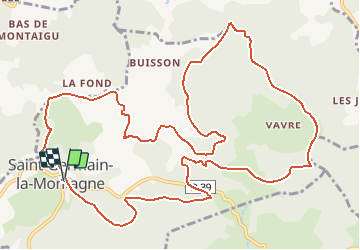
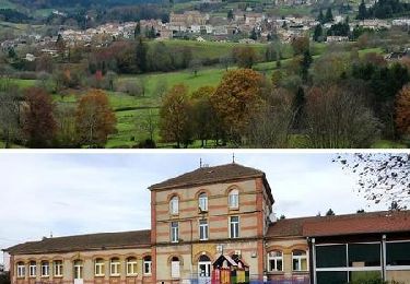
Trail Walking of 15 km to be discovered at Auvergne-Rhône-Alpes, Loire, Saint-Germain-la-Montagne. This trail is proposed by tracegps.
Description
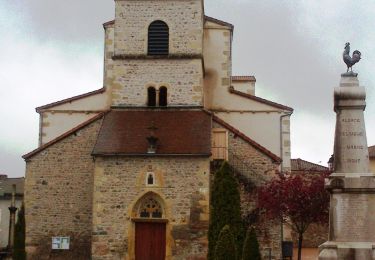
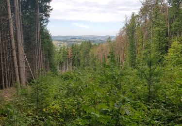
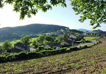
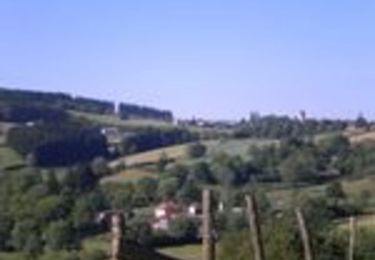
Parking et départ du panneau des circuits (photo). Le "circuit du Tourniquet" est le parcours N°1 du topoguide mentionné ci-dessous. C'est une très belle balade assez vallonnée dans un écrin de verdure où le silence surprend. Alors que les ruisseaux serpentent au creux des vallons, les villages perchés sur les crêtes scrutent l'horizon... Promenade sur des sentiers très agréables qui traversent de nombreuses zones forestières et longent de belles prairies verdoyantes.Le bruit des ruisseaux est assez vivifiant, rafraichissant et reposant. ATTENTION : en garder un peu sous la semelle pour gravir la montée finale qui est très pentue. Topoguide : Le Pays de Belmont-de-la-Loire... à pied (16 promenades entre Roannais et Beaujolais).
Positioning
Comments
Trails nearby
![Trail On foot Propières - Circuit de Propières n°3 - 15 km - Noir - Photo](https://media.geolcdn.com/t/375/260/8e2640e6-7b75-4b6e-a5e9-fe114f5074bb.jpeg&format=jpg&maxdim=2)
![On foot On foot](https://static1.geolcdn.com/sitytour/trail-icons/100.png)
On foot
![](/images/other/stat-length.png)
![](https://static1.geolcdn.com/siteimages/upload/files/16400158638029165_repeat_loop_refresh_sync_direction_icon.png)
![Trail On foot Saint-Clément-de-Vers - Circuit Bleu - Photo](https://media.geolcdn.com/t/375/260/7f9adbe1-6cfb-42fe-b291-e5722845c792.jpeg&format=jpg&maxdim=2)
![On foot On foot](https://static1.geolcdn.com/sitytour/trail-icons/100.png)
On foot
![](/images/other/stat-length.png)
![](https://static1.geolcdn.com/siteimages/upload/files/16400158638029165_repeat_loop_refresh_sync_direction_icon.png)
![Trail On foot Saint-Igny-de-Vers - Circuit des Charmes - Photo](https://media.geolcdn.com/t/375/260/94a383f9-e742-4a20-9292-f235faae47ba.jpeg&format=jpg&maxdim=2)
![On foot On foot](https://static1.geolcdn.com/sitytour/trail-icons/100.png)
On foot
![](/images/other/stat-length.png)
![](https://static1.geolcdn.com/siteimages/upload/files/16400158638029165_repeat_loop_refresh_sync_direction_icon.png)
![Trail Walking Chauffailles - 2021-11-25_10h16m53_Chauffailles Laval Arfeuilles 7.7km - Photo](https://media.geolcdn.com/t/375/260/ext.jpg?maxdim=2&url=https%3A%2F%2Fstatic1.geolcdn.com%2Fsiteimages%2Fupload%2Ffiles%2F1553511878bg_sport_marche.png)
![Walking Walking](https://static1.geolcdn.com/sitytour/trail-icons/101.png)
Walking
![](/images/other/stat-length.png)
![](https://static1.geolcdn.com/siteimages/upload/files/16400158638029165_repeat_loop_refresh_sync_direction_icon.png)
![Trail Running Chauffailles - jour 3 CAP Jeanot - Photo](https://media.geolcdn.com/t/375/260/85e932c5-a5d0-4f50-9e59-878bdb5e39a0.jpg&format=jpg&maxdim=2)
![Running Running](https://static1.geolcdn.com/sitytour/trail-icons/103.png)
Running
![](/images/other/stat-length.png)
![](https://static1.geolcdn.com/siteimages/upload/files/16400158638029165_repeat_loop_refresh_sync_direction_icon.png)
![Trail Mountain bike Saint-Igny-de-Vers - Circuit FFC M13 Saint Igny de Vers - Photo](https://media.geolcdn.com/t/375/260/ext.jpg?maxdim=2&url=https%3A%2F%2Fstatic1.geolcdn.com%2Fsiteimages%2Fupload%2Ffiles%2F1524743154velo.jpg)
![Mountain bike Mountain bike](https://static1.geolcdn.com/sitytour/trail-icons/202.png)
Mountain bike
![](/images/other/stat-length.png)
![](https://static1.geolcdn.com/siteimages/upload/files/16400158638029165_repeat_loop_refresh_sync_direction_icon.png)
![Trail Mountain bike Saint-Germain-la-Montagne - VTT sportif à travers bois - Saint Germain la Montagne - Photo](https://media.geolcdn.com/t/375/260/ext.jpg?maxdim=2&url=https%3A%2F%2Fservices.sitytrail.com%2FGeolivesWS%2FDownloadMedia.ashx%3FTrailID%3D318003%26Media%3D17457_6.jpg)
![Mountain bike Mountain bike](https://static1.geolcdn.com/sitytour/trail-icons/202.png)
Mountain bike
![](/images/other/stat-length.png)
![](https://static1.geolcdn.com/siteimages/upload/files/16400158638029165_repeat_loop_refresh_sync_direction_icon.png)
![Trail Mountain bike Belmont-de-la-Loire - Rando de la Forêt (VTT-2012) - Belmont de la Loire - Photo](https://media.geolcdn.com/t/375/260/ext.jpg?maxdim=2&url=https%3A%2F%2Fservices.sitytrail.com%2FGeolivesWS%2FDownloadMedia.ashx%3FTrailID%3D173044%26Media%3D14561_6.jpg)
![Mountain bike Mountain bike](https://static1.geolcdn.com/sitytour/trail-icons/202.png)
Mountain bike
![](/images/other/stat-length.png)
![](https://static1.geolcdn.com/siteimages/upload/files/16400158638029165_repeat_loop_refresh_sync_direction_icon.png)
![Trail Walking Propières - Circuit de Propières - Photo](https://media.geolcdn.com/t/375/260/ext.jpg?maxdim=2&url=https%3A%2F%2Fservices.sitytrail.com%2FGeolivesWS%2FDownloadMedia.ashx%3FTrailID%3D172258%26Media%3D13567_3.jpg)
![Walking Walking](https://static1.geolcdn.com/sitytour/trail-icons/101.png)
Walking
![](/images/other/stat-length.png)
![](https://static1.geolcdn.com/siteimages/upload/files/16400158638029165_repeat_loop_refresh_sync_direction_icon.png)
Super appli pour se ballader.le top :)